| My News | |
Do we fail on delivery of geospatial projects?
|
Present situation
It appears that big talk and promises about the technologies (GIS et al) have still not carried weight and conviction with the user – organizations, the ultimate beneficiary of the productivity of the modern technologies. The spatial solutions have still not reached these organizations like urban development authorities. Land Information Technologies (LIT) have not delivered spatial solutions as a matter of routine or policy.
Many well known organizations in the government sector working in LIT field have devoted more time and resources on research as compared to the practical applications. This is, perhaps, due to an impression, may be erroneous, that the career graphs of the technical persons depend more on research and less on projects and still less on solving real and current geo-spatial problems of the nation. For example, cadastral surveys of villages and base maps of towns still remain big challenges to LIT and GIS.
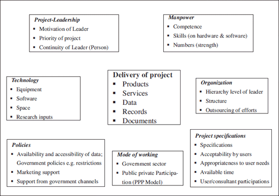
Guiding model to explain the linkages between the various factors
Scope of this paper
This paper encompasses some collected thoughts and experiences of the author on this subject of delivery of geospatial solutions. Why don’t we see many success stories? The answer to this question lies in many factors which have been highlighted in the ‘model’.
The readers are requested to validate them and add some more from their experience.
Major managerial factors of the model explained further
Most of the factors facilitating ‘delivery’ have been listed in the model. Absence of any one of those will certainly act as an obstacle – to – delivery. To maintain brevity, only the important ones have been amplified and analyzed further.
Leadership and its continuity
According to the definition, a Project is a well defined task. This definition is to be provided and manifested by the leader. A competent leader, both as a technologist and as a human-resource manager is the most important motivator for the delivery. He also needs support from all the sub-organizational ‘heads’. He should, therefore, have a hierarchical status which is commensurate with the functional requirements of the project. This will minimize the maze of sanctions, approvals and allocation of resources. It follows from above that the status of the leader should be functionally right and not merely in designation. The higher in the functional status, the better will be the chance for success.
Continuity of the leader is the least talked about subject. The leader is already imbibed with the details of the project. Therefore his ‘continuity’ for the project is essential for the momentum and team-work of the project. Many projects could not survive because continuity became a casualty.
Manpower: Competence and adequacy of numbers
Many projects fail because the technical manpower is not thoughtfully trained on the operational / practical aspects of the technology. Mere exposure to the theoretical concepts may not deliver the results. The number of persons deployed on the project is also very significant for timely completion. It is here that private organizations score over government set-ups as they can easily recruit and enhance the number of persons working on the project.
Working mode of the project
The success of a project also depends on the mode in which it is visualized to be implemented. There are several modes of working but one which is most successful has been the PPP (Public-Private Participation) model. In this model of working, a project is said to have the strength of Government office and flexibility of procedures of a private firm. Both the partners are supposed to work in a synergistic manner. Unfortunately, the reverse is also true and litigation is the result! A well thought out working model earmarking the various functions between the parties has been found very effective. For example, maps can be produced by the Survey of India employing photogrammetry etc while their revision, derived maps can be entrusted to private firms. A private firm may have the manpower but not the software or the equipment.
Technology, data from various sources
A quick look at the website of NSDI will show the various organizations who are in the charter of producing land information, namely Forest Survey of India, Survey of India, National Bureau of Soil Survey and Land Use Planning, etc. Each department produces data/ map etc only according to its charter. On the other hand GIS by definition and by application is a spatial solution based on the multi-disciplinary data.
Therefore it becomes a great time taking exercise to collect data from different sources located all over India. In addition, one has to know where, what, in what form, the data is available / accessible. This phase of the project is extremely tedious. Only the most patient survive this ordeal!
As an example, take the case of Meerut, a city in Uttar Pradesh in India. If you have a GIS project, the topographies available is of 1973 edition. The need for GIS is for larger scales e.g. 1:5000/1:10,000 or larger. This implies that fresh topographical surveys will have to be undertaken. That adds one more year to the project and a lot of headache. So the time for a GIS project becomes: 12 months+2minutes. Topographic layer is an important layer of GIS as all the other spatial information is hooked on to it.
The modern technology of photogrammetry is helpful in such situation. But be aware of restriction policy.
The cardinal experience regarding data is that:
Data is not given, it is always obtained.
In such a scenario, one can easily imagine the pitfalls: various out-of-station journeys, e-mails etc. A ray of hope can, however, be found in my suggestion for augmentation of charter for NSDI, described further.
NSDI-A plea for augmentation of objectives – structure (Please refer to portal)
The author has suggested (in another paper) that the charter of NSDI should be augmented to a level where NSDI not only gets the desired data from its constituents but should organizationally take them in its administrative network. This could be done in a phased manner. NSDI may need a very major reorganization. It should be a part of a freshly constituted ministry of geo-surveys.
It is visualized that only then the GIS will be turned into a successful tool which will deliver results. Meanwhile, NSDI should collect and collate all necessary, non-restricted data and publish them on its portal.
Project specifications
The specifications should be deliberately made simple, especially if the project is a first time or proof-of –technology project. It is a better strategy for success. It is seen that in many cases BEST becomes the enemy of GOOD. The specifications could be improved in subsequent projects. It will be a good idea if the ‘users’ or consultant to the user organization could be involved while making specifications.
Policies of government
Many policies of the government e.g. restriction policy have proved counter productive to the introduction of aerial photography etc. A re-look is necessary.
Conclusion
The paper draws attention to some of the major difficulties in bringing a geospatial project to a successful end. The difficulties (call them as challenges) will be quite formidable as they emanate from areas which can be called:
Multidisciplinary
Multi-organizational
Multi-locational
These will always be a part of a geospatial project. A judicious use of project – management techniques, as mentioned above may be useful.
 |
|
||||
My Coordinates |
EDITORIAL |
|
His Coordinates |
DR BRADFORD W PARKINSON |
|
News |
INDUSTRY | LBS | GPS | GIS | REMOTE SENSING | GALILEO UPDATE |
|
Mark your calendar |
MARCH 2010 TO OCTOBER 2010 |


 (No Ratings Yet)


Leave your response!