Geo Week
February 13-15, 2023
Denver, USA
DGI 2023 – Geospatial Intelligence for National Security
27 Feb to 01 March
London, United Kingdom
Geo Connect Asia
15-16 March 2023
Singapore
Drones Asia
15-16 March 2023 Singapore
Digital Twins 2023 (Virtual)
23 March 2023
GEO Business 2023
17-18 May
London, UK
RIN Baska GNSS Conference (& Smart Maritime Workshop)
14-19 May 2023 Baska, Croatia
9th International Conference on Geomatics and Geospatial …

Best practice implementations needs to reflect experience: with cost effective world leading operational national systems; several generations of change i.e. experience with different models of private sector and public sector collaboration; in creating and extending systems of policy, regulation and governance; of the affects of different governance regimes, cultures and from international programmes. They therefore need to cover:

“The first man who, having fenced in a piece of land, said, ‘This is mine,’ and found people naïve enough to believe him, that man was the true founder of civil society.” (from Discours sur l’Origine et le Fondement de l’Inégalité Parmi les Hommes, 1754, – Jean-Jacques Rousseau)

Metadata is commonly defined as “data about data” and also plays a critical role in any Spatial Data Infrastructure (SDI) initiatives. Metadata not only provides users of spatial data with information about the purpose, quality, actuality and accuracy of spatial datasets, but also performs vital functions that make spatial data interoperable, that is, capable of being shared between systems…

Vol. VI, Issue 2, Feb 2010
Zip
Defining civil PNT requirements
John W Lavrakas
MISSION 2020: Land Titling Project
P Misra
GNSS support to canine search and rescue
José Caro and Manuel Prieto
Fuzzy strong tracking unscented
Kalman filter
Dah-Jing Jwo, Fong-Chi Chung and Shih-Yao Lai
My Coordinates
EDITORIAL
Book
Land administration for sustainable development
Conference
The First Asia Oceania Regional Workshop, Survey camp
News
INDUSTRY | GPS | GALILEO UPDATE | …
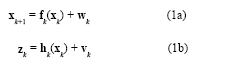
The Global Positioning System(GPS) (Brown and Hwang 1997; Farrell and Barth 1999; Gelb 1974) and inertial navigation system (INS) have complementary operational characteristics and the synergy of both systems has been widely explored. An integrated GPS/INS system is typically carried out through the extended Kalman filter (EKF). The EKF is the approximate nonlinear filters which linearizes the system…

Earthquakes, landslides, avalanches, collapsed buildings… There are many situations in which people could suddenly become trapped and unable to free themselves without the assistance of search and rescue professionals…

Consider the scenario, date 1.1.2020: “Mr. A buys property in Meerut, city in Uttar Pradesh (UP), India from Mr. B in Dec 2019. The ownership-title that Mr. B is the Owner, is guaranteed by the Government Registrar. As a matter of fact, all the properties with the names of their owner are recorded centrally in the computer in the office of Land Survey Department of UP. The location like trees and wells, etc are all photographed on an aerial photograph…

Today, the civil positioning, navigation, and timing (PNT) community needs a clear and concise statement of PNT needs. This statement should incorporate all aspects of PNT services and all applications and modes of PNT use. With such a statement, providers of PNT technology and services will be better able to plan for, develop, and implement their PNT services. While I offer my thoughts on this need for the United States, the arguments…

E-Government (or Electronic Government) is described in Wiki as the use of information and communication technology to provide and improve government services, transactions and interactions with citizens, businesses, and other arms of government…


 (5.00 out of 5)