Articles in the Articles Category


As the world’s diplomats
Grapple in Paris to clinch the climate deal
At United Nations Conference on Climate Change,
The 2nd International Symposium on Disaster Management was an invite-only event held over 3 days at the University of Melbourne which attracted over 130 attendees…
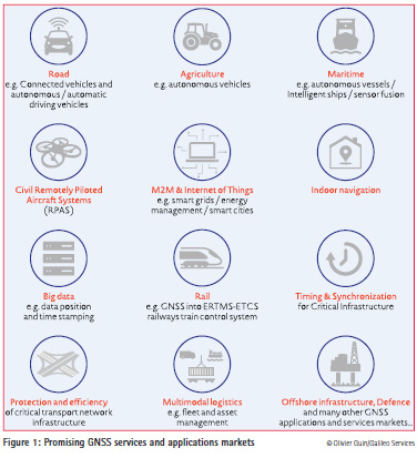
The GNSS downstream market continues to be one of the most promising markets in terms of European growth, with anannual growth rate of the global…

The territory of Bulgaria is one within the Balkan Peninsula region with active tectonics and seismotectonics. A number of geodynamical investigations try to give an…


Geoinformation is the global language that decision-makers all understand. This places the geoinformation sector, with its technologies and solutions, in a key position to deliver information that can be used to make decisions…

Survey Department, under the Ministry of Land Reform and Management, is the National Mapping Organization (NMO) of Nepal. The Department is responsible…
The number of people living in informal settlements around the world is difficult to measure precisely, but some estimates put it at close to one billion, or almost one…

This document presents some results of the scientific research conducted by Training on EGNOS-GNSS in Africa (TREGA) laboratory members concerning the…


 (5.00 out of 5)