| Mapping | |
Applicability of rotary UAV for vegetable crop investigation
This study deals with the applicability of a small rotary UAV for crop analysis of vegetables. The result shows that UAV photogrammetric technique proves to very useful for analyzing |
 |
|
 |
|
 |
|
 |
|
UAV (Unmanned Aerial Vehicle) is the latest photogrammetric system which has been used across many fields such as a military reconnaissance, heritage site documentation, a precise agriculture mapping, a construction site mapping, a real-time hazard mapping project, etc. In domestic sphere, National Emergency Management Agency (NEMA, 2007) performs the calculation of the amount of estimated damage and development of the module. In this task, low altitude UAV image correction and its improvement, image processing techniques developed to apply low altitude image to the damage information and the resolution analysis of low altitude image information were performed. Jung et al (2010) carried out 3D spatial data acquisition with UAV photogrammetry. Jung et al (2012) deals with the system development for crop growth management using unmanned aerial remote sensing technique. Kim et al (2010) analyzed the adaptability of damage from storm and flood monitoring using small UAV. It was then proved that UAV could contribute to various disaster prevention and measures such as river disaster, slope accident, sediment disaster (farmland flooding and sedimentation), shore disaster and wind disaster. Lee et al (2012) introduces the UAV focusing on cadastral enabled application in Korea Cadastral Survey Corp.
And Cunningham et al (2011) introduces the cadastral application in rural area in Alaska, USA. Bendig et al (2013) carried out crop surface model production based on UAV stereo-images for rice monitoring in northeast of China. Eisenbeiss (2009) performed the UAV Photogrammetry for agricultural applications. In USA, different agency and state will look for a variety of purposes for UAV utilization such as avalanche control (Washington State’s Department of Transportation), fight fires (US Forest Services), a law enforcement tool (state and local police departments in Maryland, Alabama, Texas, Florida, Washington, Arkansas, and Utah) (Better world campaign, 2013), among others. Aeryon Labs Inc., shows how unmanned aerial vehicles help with construction projects (Dcnonl, 2012).
This study deals with UAV photogrammetry for crop analysis and considers its applicability for vegetable crops. The author tries to overlay seamless cadastral map with UAV digital image, supporting the crop statistics agency making a rapid and objective decision for crops. The results show that UAV photogrammetry is reasonable for identifying its crop growth status in terms of the image quality, timesaving and task-effectiveness.
Rural crop survey
The United States Department of Agriculture’s (USDA) National Agricultural Statistics Service (NASS) has researched and used remote sensing technology for acreage estimation since the early 1970s. Significant advancements in recent years have enabled NASS to transition the use of remote sensing from primarily a research function to performing an integral role in the agency’s crop acreage estimation program, covering all major crops grown in high producing states in the US (Bailey and Boryan., 2010). China is a big agricultural production, agricultural product consumption and trading country, the abundance of crops have long been paid much attention by society and government. China started to study remote sensing technology for crop acreage by National Bureau of Statistics of the People’s Republic of China, 2003 (Zhang et al, 2010). With 3S (RS, GIS, GPS), the on-site survey system was constructed and the estimation of crop production with remote sensing is preceded rapidly. The crop model is developed successfully and is about to carry out a test survey (NSO, 2010). EU (Europe Union) is focusing on identifying the current situation of the food production, and is constructing the satellite image-based sample survey system in order to investigate 8 crop acreage with 60 image sample (40km*40km) in total. Through this, EU tries to predict the 11 crop production for 35 countries. In South Korea, the agency says that rural crop survey is carried out on the ground (10 times/year). This causes problems such as high-cost, lowaccuracy, labor-intensive for crop survey, etc. Therefore, a government tries to substitute and supplement the existing method with remote sensing technology, making the statistics production to be scientific, precise, and resulted in costand labor effective. Nowadays, the agency tries to investigate the cultivated area with remote survey technique. In near future, remote sensing will be put to use at cultivated area acreages investigation. But, crop production and the estimated amount survey will need more high technology; therefore it should be planned in the long-term (NSO, 2010).
Test site and data acquisition
Test site
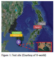
The test site, Haenam-gun, Jeollanam-do is located to the southwest of South Korea. Haenam-gun’s area is 992.87km2, but the test site had an area of 2,523m2, with one area of 1,792m2 and the other one 731m2, consisting of 2 cadastre parcels. The test site is very flat, no ground obstacles, no dense forest and open sky, which is no problem for UAV. Haenam is popular for nap cabbage which is harvested in winter.
UAV photogrammetric data acquisition
This pilot project was conducted by Department of Business of Korea Cadastral Survey Corp (KCSC), Spatial Information Research Institute (SIRI) attached to KCSC, and Korea Rural Economic Institute (KREI) in Haenamgun. KREI is in charge of estimating the price and supply on demand of agricultural and stockbreeding products according to law, and then publishing it monthly.
In this study, UAV is manufactured by Spatial Research Institute (SIRI). The main components of the UAV are a remote control, the flight control software and its body. Equipped with six rotors, the UAV system possesses a maximum payload of 6.5 kg. Other important elements of the UAV are one GPS (Global Positioning System), one linear accelerometer, and two Gyros (e.g. IDG-500, IDZ-500). The detailed specification of UAV (Hexacopter) is prescribed in Table 1.
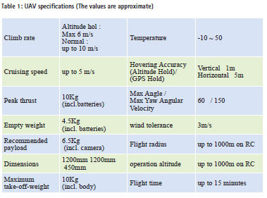
In particular, this UAV is just a prototype model for test. Hexacopter has 6 blades where 3 blades rotate in clockwise direction and 3 blades rotate counter-clockwise. Figure 2 shows an example of UAV (Hexacopter) and a digital image taken with a camera mounted on LX-UAV. In the test, UAV flies over 20 m ~ 100 m altitude.
Data processing and analysis
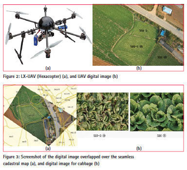
Figure (3a) shows the screenshot of the digital image overlapping the cadastral map. By rubber shifting method, the digital image and the seamless cadastral map were compulsory moved and rotated, and then overlapped together even though there is some inconsistency between them. Figure 3(b) shows the screenshot of digital image taken over about 100m and 20m altitude on the ground. This process is supposed to be reasonable and cost-effective for a rural agency to have a quick look of crop growth survey in the office instead on site.
Conclusion
Small UAV images are taken in order to survey the farm products at the local province in South Korea as a pilot project. The results show that UAV digital images are enough to be reasonable for analyzing the parcel area, cabbage density, and crop. In high altitude flight (about 100m), it is possible to identify the crop approximately; in low altitude, it shows a good resolution image enough to distinguish leaf status and crop growth status. UAV digital images are expected to play a good role in providing objective data for crop analysis. And the seamless cadastral map was overlaid on top of the UAV digital image, encouraging rural agency to make a quick decision for crop analysis. In other words, it is required that the extension of flight duration time, image quality improvement due to wind, etc., and buying insurance for safety people, etc., should be considered for various applications.
References
Bailey, J.and Boryan, C., 2010, Remote Sensing Applications in Agriculture at the USDA National Agricultural Statistics Service, cited from http://www.fao.org. Bendig, J., Willkomm, M., Gnyp, M. L., Bennertz, S., Qiang, C., Miao, Y., Lenz-Wiedemann, V.I.S., 2013, Very high resolution crop surface models (CSMs) from UAV- based stereo images for rice growth monitoring In Northeast China, International Archives of the Photogrammetry, Remote Sensing and Spatial Information Sciences, Volume XL-1/W2, 2013 UAV-g2013, 4 – 6 September 2013, Rostock, Germany.
Betterworldcampaign, 2013, The UN’s Use of Unmanned Aerial Vehicles in the Demoratic Republic of the Congo: U.S. Support and Potential Foreign Policy Advantages, p.11.
Cunningham, K., Walker, G., Stahlke, E. and Wilson, R, 2012, Cadastral Audit And Assessments using Unmanned Aerial Systems, International Archives of the Photogrammetry, Remote Sensing and Spatial nformation Sciences, Vol. XXXVIII-1/C22 UAV-g 2011, Conference on Unmanned Aerial Vehicle in Geomatics, Zurich, Switzerland.
Dcnonl, 2012, How unmanned aerial vehicles help with construction projects, Daily Commercial News, cited from http://dcnonl.com/article/id48915 Eisenbeiss, H., 2009, UAV Photogrammetry, The degree of Dotor of Science, Institut für Geodäsie und Photogrammetrie Eidgenössische Technische Hochschule Zürich Wolfgang- Pauli-Strasse 15 8093 Zürich.
Jung , Sung Heuk, Lim, Hyeong Min, Lee, Jae Kee, 2010, Acquision of 3D spatial information using UAV photogrammetric method, Korean Journal of Geomatics, 28(1), pp.161-168.
Jeong, Seungtaek, Ko, Jonghan, Yeom, Jong-Min, and Kim, Han-Yong, 2012, Crop Information Delivery System using and Unmanned Aerial Vehicle, 2012 Proceedings of KAGIS Fall Conference, November 8~10, Jeju University, Jeju, pp. 296-297.
Kim, Min Gyu, Jung, Gap Yong, Kim, Jong Bae, Yun, Hee Cheon, Applicability Analysis of UAV for Storm and Flood Monitoring, Korean Journal of Geomatics, 28(6), pp. 655-662.
Lee, InSu, Seo, Gab-Soo, Kim, Su-jeong, and Sung, Tea-su, 2012, The Applicable Method of Aerial Photogrammetry Technology for Cadastral Surveying, 2012 Proceedings of The Korean Society of Cadastre Fall Conference, December 7, NAMSEOUL University, Cheonan, pp. 33-41.
NEMA (National Emergency Management Agency), 2007, Development of damage estimation module using geospatial imagery information.
NSO (National Statistical Office), 2010, Rural statistics production using Satellite, Report Nr. 2010-17, written in Korean. Zhang Fumina., Zhu Zaichunb., Pan Yaozhongb., Hu Tangao. and Zhang Jinshui , 2010, application of remote sensing technology in crop acreage and yield statistical survey in China, Meeting on the Management of Statistical Information Systems (MSIS 2010) , Daejeon, Republic of Korea, 26-29 April 2010, pp.1-13.
The paper was presented at FIG Congress 2014, Kuala Lumpur, Malaysia, 16 – 21 June 2014


 (10 votes, average: 3.80 out of 5)


Leave your response!