Articles in the Articles Category

Filipo Rodriguez, Gian Paolo Plaia
Application of cognitive psychology for reduction of mapping errors
Human factors contributing to mapping errors made by operators working on digital mapping systems were studied from Cognitive Psychology perspective to evolve suitable strategies to reduce errors.
Mapping errors
Study area
Large scale topographic maps of better than 1:5000 scale with 1 to 2 m contours are …
April 2008
MELAHA 2008
13-15 April Hurghada,
Egypt
ain@aast.edu
http://www.ainegypt.org
GEO-SIBERIA 2008
April 22 – 24, 2008, Novosibirsk , Russia
strutz@sibfair.ru
http://geosiberia.sibfair.ru/eng/n
Toulouse Space Show’08
22-25 April Toulouse, France
contact@toulousespaceshow.eu
http://www.toulousespaceshow.eu/toulouse_space_show.htm
May 2008
IEEE/ION PLANS 2007
Co-sponsored by IEEE and Institute of Navigation
May 5-8, 2007
Monterey, California, USA
http://www.plansconference.org
June 2008
International conference: “Studying, Modeling and Sense Making of Planet Earth”
1 – 6 June, 2008
Department of Geography,
University of …

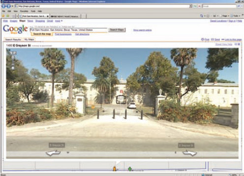
Does Google have multiple standards?
The Pentagon has banned Google from taking photographs and video footage of US military bases after images showing important security features of a base in Texas appeared on the company’s website. The Defence Department’s ultimatum came after images showing entry gates, barriers and buildings within the Fort Sam Houstan base, in …

Over the past 100 years the world’s total population has quadrupled – from 1.6 billion to 6.6 billion. (Footnote: Population Bulletin, “World Population Highlights: Key Findings From PRB’s 2007 World Population Data Sheet” http:// www.prb.org/Articles/2007/623WorldPop. aspx.) In many parts of the world we see growing poverty. We now face increasingly worrisome resource constraints and environmental difficulties…

Although Global Navigation Satellite Systems (GNSS) technology is developing rapidly, the major disadvantage of GNSS will still exist even when the European Galileo system is fully operational, that is, signal blockage due to obstructions and the low power of the signals. The combination of GNSS with a self-contained inertial navigation system (INS) provides an ideal solution, which can not only address the weakness of GNSS and but also bound…

Ground segment of GAGAN i.e. Indian Reference Station (INRES) at Delhi, Kolkatta, Guwahati, Portblair, Ahmedabad, Banglore, Jammu and Trivanthapuram is in place. Except Portblair, other stations have been connected to Indian Master Control Center (INMCC) with fiber optic cable in synchronous loop mode. Portblair is connected through dedicated satellite communication network. Its integration and connectivity test with seven INRES with INMCC have been completed. The INRES data is being received through fiber optic cable at INMCC Banglore for corrections and validation checks of the erroneous data. Preliminary Site Acceptance Test (PSAT) of GAGAN ground element was conducted in May 2006 with help of satellite emulator.

Navigational regionalism
Global Navigational Systems could have served the globe.
However, regions have specific needs.
Moreover, aspirations.
Aspirations to own and control the technology.
Owning makes sense as it adds to the might.
The desire and importance of ‘being mighty’ cannot be undermined.
So the pace for regionalism in navigation system may increase.
Still, they may work in cooperation. Hopefully.
…

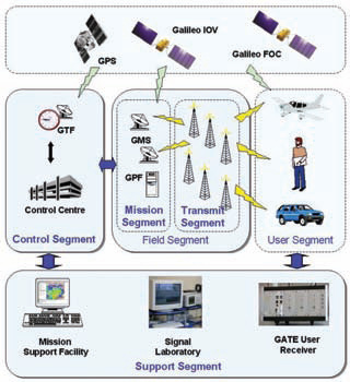
GATE is a ground-based realistic test environment for developers of receivers, applications and services for the future satellite navigation system Galileo. GATE is currently being builtup and as from beginning of 2008 – several years before Galileo becomes fully operational – Galileo signals will be emitted by 6 earth-fixed transmitters in the area of Berchtesgaden, located in the southeast of Germany in the German Alps. This will provide the opportunity for receiver, application and service developers to perform realistic field-tests of hardware and software for Galileo at an early stage. In this way GATE will also support German and European products for Galileo entering the market.
While the motivation of the US groundbased ranging test bed Yuma in the 70’s was to prove the concept of satellite navigation, no one doubts that Galileo will work from a conceptual point of view. However, it is still an ambitious technological project, introducing a signal structure far more sophisticated than the GPS C/A Code. In fact there are three major mission objectives to be covered by GATE – Signal Experiments, Receiver Testing and User applications.

RECENTadvances in information and communication technology (ICT)
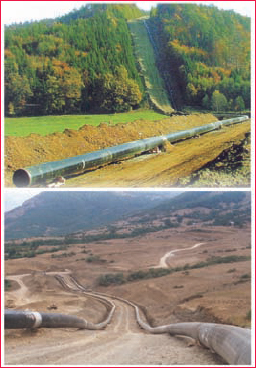
have resulted in a changing environment with many interdependencies between organizations. There are various data services produced and consumed within the process of enhancement of pipelines project. This happens along the various phases; feasibility study, land allocation, execution and operation. Problems in data sharing arise from the fact that data services are not properly documented resulting in difficulties in updating data, data duplication and long administrative inter–organisational procedures[1]. This article presents a method for elaborating the trade-off between existing situation and the desired future in case of improving conditional data sharing.

This mega thrust earthquake of Dec 26, 2004 shifted several sites on Indian and Eurasian plates, which has been quantified from various GPS studies. As the relative change in triangular area between different sites is more sensitive than the relative change in their coordinates, it has been attempted to calculate the anomalies in triangular area on daily basis between 12 permanent GPS stations of C-MMACS and 16 IGS stations for a period of 60 days from 1st Dec 2004 – 30th Jan 2005.


 (5.00 out of 5)