Articles in the Articles Category
Bentley has introduced the ‘Be Employable’ initiative. Can you explain what it is designed to accomplish?
Malcolm Walter: Worldwide, the infrastructure community is facing the relentless pressures of a diffi cult economy, and the downsizing of design and engineering organizations has become widespread. Bentley’s mission of ‘sustaining infrastructure’ encompasses the need to ‘sustain the professions’ that design, build, and operate our infrastructure, and the Be Employable program is dedicated to doing just that.
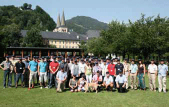
Th e ESA International Summer School on GNSS 2009 was held from July 20th to 30th in Berchtesgaden, Bavaria – Germany. Aft er the great successes in 2007 and 2008 the European Space Agency adopted the International Summer School on GNSS which itents to educate Satellite Navigation in an intersdisciplinary way and give a comprehensive overview on the design and development of satellite navigation systems and its applications. Bernd Eissfeller, leading organizer and director of the Institute of Geodesy and Navigation of the University FAF, Munich was plesed about this change. “Not only ESA is now part of this international activity concerning GNSS education”, he pointed out, “but also many high ranking universities which supported the Summer School for the fi rst time.” Th e 2009 organizing committ ee consisted of Eissfeller`s institute, the Stanford University (USA), the Institute Supérieur de l`Aéronautique et de l`Èspace (France), Aalborg University (Denmark) and Graz University of Technology (Austria). 47 participants from all over the world joined Summer School 2009, i.e. Russia, China, Australia, etc.
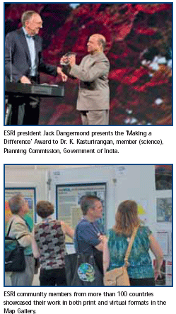
“Thank you for attending this year,” said President Jack Dangermond, ESRI, as he welcomed attendees at the 2009 ESRI International User Conference (ESRI UC). “Many things have taken place over the last year, and I’m particularly grateful you are here with us today. I know some of you came on your own money and traveled halfway around the world–I can’t say how much I appreciate that.”
November 2009
International Symposium on GPS/GNSS 2009
4-6 November
Jeju, Korea
gnssws@gnss.or.kr
www.gnsskorea2009.org
NAV09
Maritime : 10 November, Southampton
Positioning & Location:12 Nov., Nottingham
Land : 19 November, Teddington
Timing : 20 November, Teddington
Air:25 Nov., london
www.rin.org.uk/news-events/events
WALIS International Form 2009
11-13 November
perth convention Exhibition Centre, Australia
www.Walis.wa.gov.au
INCA 2009
25-27 November
Kolkata, India
http://www.incaindia.org
ISPRS (Geospatial Data Cyber Infrastructure)
25-27 November
Hyderabad, India
http://www.incois.gov.in/isprs
GPS/IGNSS Symposium 2009
30 Nov – 1 Dec 2009
Tokyo, japan
www.gnss-pnt.org/symposium2009

“I always read that the world, land and water, was spherical… Now I observed so much divergence, that I began to hold different views about the world and I found it was not round…. but pear shaped, round except where it has a nipple, for there it is taller, or as one had a round ball and, on one side, it should be like a woman’s breast, and this nipple part is the highest and closest to Heaven….” – Kenneth C. Davis New York Times Best Seller “Don’t know much about Geography” Permissions Department, William Morrow and Company, New York, NY, 1992.

We have Bhuvan now!
Few months back, ISRO announced its plans for Bhuvan.
And now it is a reality.
An Indian earth observation visualization portal.
Showcasing Indian imaging capabilities.
Unique and different.
From India and for India.
Open to public.
There is euphoria; there are expectations.
And a long way to go.
The first step has been taken.
Kudos to ISRO.
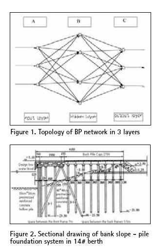
The high pile wharf has the advantage of slight wave reflection, steady anchoring condition, little investment and the construction time being short. Therefore it has been widely used in coastal areas where the ground has soft soil. But, on the other hand its penetrant structure raises some problems also for the structure. In order to guarantee the request of ships draft, the front water area of the wharf has to be dug more deep,…

The term Terrestrial 3D Laser Scanning scan is commonly referred to the process of collecting large number of data points through high performance hardware devices (3D Laser Scanners) delivering raw data outputs in the form of point clouds or cloud of points (CoP). The concept of High-Definition surveying, on the other hand, extends the capabilities of 3D Laser Scanners by providing effective field and office workflow solutions in combination…
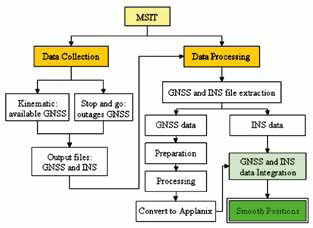
An inertial navigation system (INS) is a self-contained navigation system that primarily measures position, velocity and attitude. The system’s inertial frame measures the accelerations and the rotations by using an inertial measurement unit (IMU). The IMU is a group of six inertial sensors which are three linear accelerometers and three gyroscopes (gyros)…




 (5.00 out of 5)