Articles in the Mycoordinates Category


The high pile wharf has the advantage of slight wave reflection, steady anchoring condition, little investment and the construction time being short. Therefore it has been widely used in coastal areas where the ground has soft soil. But, on the other hand its penetrant structure raises some problems also for the structure. In order to guarantee the request of ships draft, the front water area of the wharf has to be dug more deep,…

The term Terrestrial 3D Laser Scanning scan is commonly referred to the process of collecting large number of data points through high performance hardware devices (3D Laser Scanners) delivering raw data outputs in the form of point clouds or cloud of points (CoP). The concept of High-Definition surveying, on the other hand, extends the capabilities of 3D Laser Scanners by providing effective field and office workflow solutions in combination…

An inertial navigation system (INS) is a self-contained navigation system that primarily measures position, velocity and attitude. The system’s inertial frame measures the accelerations and the rotations by using an inertial measurement unit (IMU). The IMU is a group of six inertial sensors which are three linear accelerometers and three gyroscopes (gyros)…
“We are convinced that if we are to play a meaningful role nationally, and in the community of nations, we must be second to none in the application of advanced technologies to the real problems of man and society.”…
INDUSTRY | LBS | GPS | GIS | REMOTE SENSING | GALILEO UPDATE
wireless adapter can take advantage of its positioning technology and locate a user. Users
Opera Software and Skyhook Wireless …
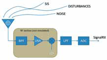
The current panorama of navigation satellite systems is rich of proposals for novel modulations and bands, to be prospectively used in the current and incoming systems. In this perspective, the know-how on the inherent nature of signals and systems is a fundamental resource to proactively cope with the multiple aspects of interaction and integration among signals, services and applications…

Of course, it would be extremely rare, when any GPS surveying and/ or “navigating” to the North Pole is undertaken. One such opportunity occurred In April 2005. British explorer Tom Avery in his effort(s) to recreate Adm. Robert Peary’s epic journey of April 1909 to North Pole took GPS to navigate himself…

Indian Institute of Surveying and Mapping (IISM) is the country’s premier institution for human resources development in the realm of surveying and mapping in its modern incarnation. IISM recognizes that the cutting edge in the process of development is information dissemination. Hence, its efforts of generating awareness among various organization and training its manpower in modern trends in Surveying & Mapping like GPS, Total Station,…
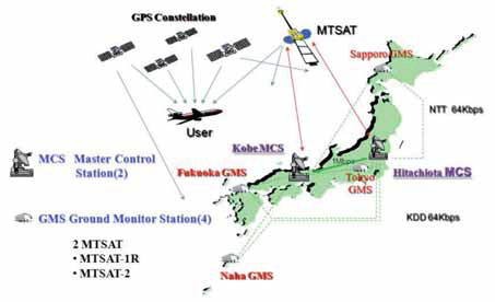
The Multi-functional Satellite Augmentation System (MSAS) is a Japanese Satellite Based Augmentation System (SBAS) [1] which provides Differential GPS (DGPS) corrections and is designed to supplement GPS by reporting and monitoring the reliability and accuracy of GPS signals in real time. MSAS consists of two satellites, (MTSAT-1R at 140E longitude and MTSAT-2 at 145E longitude), four Ground Monitor Stations (GMS), two Master Control Stations (MCS),…

GPS import in India was derestricted in Jan,04 – Bal Krishna, june’05
If we go strictly by rule that exists on paper, making a GPS operational without a license from WPC is not allowed – P. K. Garg, July’05If GPS needs a license to operate in India then what is the procedure
for obtaining that license – Sudipto Roy, Jan07
It was easy to have detected Sumatra Offshore Earthquake from GPS – Shunji Murai and Harumi Araki, July’05 Rapid data acquisition and information services have contributed greatly to the rescue work and disaster relief efforts in Wenchuan Earthquake – Deren Li, July’08


 (5.00 out of 5)