Articles in the GNSS Category



Digital signal processing plays a fundamental role in any Global Navigation Satellite System (GNSS) receiver…

This training was organized in the African Regional Centre for Space Science and Technology – in French Language (CRASTE-LF) in February 2015 and January 2017 and in school Mines-Télécom in 2011, 2012, 2014, 2015, 2016 and next in February 2017…
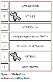
Whilst Europe has benefitted for a number of years from the European Geostationary Navigation Overlay Service (EGNOS) and North America from the Wide Area Augmentation Service…

On 15 December last year, during a ceremony which was attended by all the main actors of the Galileo program at institutional level (Commissioner Bienkovska and Commissioner…

This paper presents a study made for the Seminar on Space Weather and its effects on GNSS held in conjunction with United Nations/Nepal workshop on the applications…

Monitoring is the fastest growing discipline in the survey market. Surveyors undertake the difficult task to answer…

GNSS-based localization is no more or less secure today than it was a decade ago. From a technical standpoint, GNSS has always been vulnerable, and the equipment required to compromise it has long been accessible to everyone…

The GAGAN (GPS Aided Geo Augmented Navigation) system is a Space Based Augmentation System (SBAS) developed jointly by AAI and ISRO to deploy and certify an operational SBAS for the Indian Flight Information Region (FIR)…

For intelligent transportation systems the information of any vehicle location in an absolute geodetic reference frame is essential. These locations can be estimated best on the basis of global navigation satellite systems combined with auxiliary sensors.

During the last decade, the number of applications relying on Global Navigation Satellite System (GNSS) has experienced an exponential growth….