Articles in the GNSS Category


This paper introduces a summary of the GEMNet system, and presents two sets of results. Firstly, characteristics of interferers observed operationally along with…
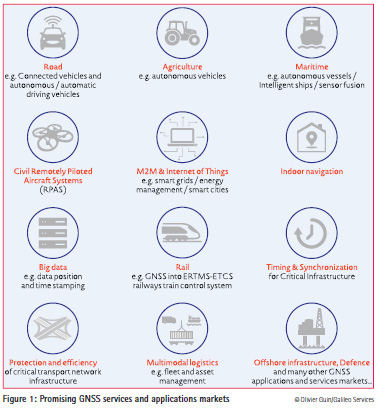
The GNSS downstream market continues to be one of the most promising markets in terms of European growth, with anannual growth rate of the global…

The territory of Bulgaria is one within the Balkan Peninsula region with active tectonics and seismotectonics. A number of geodynamical investigations try to give an…

This document presents some results of the scientific research conducted by Training on EGNOS-GNSS in Africa (TREGA) laboratory members concerning the…

With fully operational GLONASS, scope for use of Multi-GNSS has increased as GLONASS may be used along with GPS. This paper describes a study from India on the use of GLONASS with GPS for position solution. Increasing number of GLONASS satellite signals were used sequentially…

Operational and emerging Global Navigation Satellite Systems (GNSS) GPS, GLONASS, Galileo and others provide high-accuracy determination of position, velocity and time for land, marine, airborne and other kinds of users.

Because receiver autonomous integrity monitoring (RAIM) techniques are based on measurement redundancy, multi-constellation signals will have a positive impact in principle on the integrity monitoring performance of RAIM algorithms. Increasing reliability and resilience of next generation…

Global Navigation Satellite System (GNSS) is now becoming increasingly popular because of its several advantages. Along with the operating GPS, revitalized….

From the beginning of 2008, we have been facing a period of high solar activity linked to solar cycle #24. Taking into account a typical duration of eleven years, solar cycle 24 would have just reached halfway point…

The present Position, Navigation and Timing (PNT) world infrastructure is mainly based on the American Global Positioning System (GPS), complemented by other Global Navigation Satellite Systems, such as the Russian GLONASS and the forthcoming European Galileo and Chinese Beidou…


 (5.00 out of 5)