
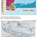
The aim of this research is to produce a new and updated map Lagos Island Local Government Area, Nigeria and document changes that have occurred over time
Leonard Michael Onyinyechi Aminigbo
Department of Geography and Environmental Management, Rivers State University, Portharcourt, Nigeria
Abstract
The scope of the research work comprised the planning and preliminary data requirement analyses, acquisition of …

The results of the study conducted in Perth, Australia show distinct advantages of using spatial statistics at the site investigation scale, and for measuring multiple elements not just potential contaminants
Andrew W. Rate
School of Agriculture and Environment, The University of Western Australia, Australia
Abstract
Public recreation areas in cities may be constructed on land which has been contaminated …

The expected results will be a contribution to the assessment of natural risk and seismic hazard in the study area and will have a positive impact for the sustainable development of the region
Nikolay Dimitrov
Assoc Professor, Head of Department Geodesy, National Institute of Geophysics, Geodesy and Geography, Bulgarian Academy of Science, Bulgaria
Introduction
The study of recent crustal …

Volume XVIII, Issue 5, May 2022
Local Moho estimation using gravity inversion
H M I Prasanna
Evaluation of KSACORS-based network GNSS-INS integrated system for Saudi coastal hydrographic surveys
Mohammed El-Diasty
Mapping the urban atmospheric carbon stock
MD Abdul Mueed Choudhury, Ernesto Marcheggiani, Andrea Galli, Giuseppe Modica and Ben Somers
Is India’s forest cover really increasing? Official maps don’t tell you the whole …

The recently released image
Captured by Event NASA’s Event Horizon Telescope (EHT)
Said to be the first visual evidence of the black hole.
This could be made possible due to the efforts of more than 300 researchers from 80 institutions around the world.
Though the black hole cannot be seen itself,
The view captures light …
June 2022
ISPRS Congress 2022
6-11 June Nice, France
https://www.isprs2020-nice.com
8th International Conference on Cartography and GIS
20 to 25 June 2022 Nessebar, Bulgaria
https://iccgis2020.cartography-gis.com
July 2022
IGARSS 2022 (hybrid form)
17-22 July 2022 Kuala Lumpur, Malaysia
https://igarss2022.org
August 2022
GeoCart’2022
24 – 26 Aug Wellington, New Zealand
https://www.cartography.org.nz
September 2022
15th Conference on Spatial Information Theory (COSIT)
5-9 Sep 2022 Kobe, Japan
cosit2022.iniad.org
Commercial UAV Expo Americas
6-8 September 2022 Las Vegas, USA
www.expouav.com
17th Symposium …
New Airborne LiDAR Series by CHC navigation
CHC Navigation have recently released the AlphaAir 140 and AlphaAir 2400 LiDAR systems. Both are very lightweight and compact airborne laser scanners that are easily installed on various UAV platforms or small survey aircraft and helicopters. They are ideally adapted to high-density point corridor mapping applications, day or …
Pixxel launches first commercial satellite
Pixxel, the Indian Space-tech startup has launched its first commercial satellite, TD- 2. It is a full-fledged commercial satellite that hosts one of the highest resolution hyperspectral commercial cameras to be ever flown. It has been launched with SpaceX’s Falcon-9 rocket, in order to build a 24×7 health monitor for …
Nearmap and DroneShield join forces
DroneShield Limited has announced an enhanced version of its DroneSentry- C2TMCommand-and-Control software, in partnership with location intelligence firm, Nearmap. It provides an intuitive and feature-rich software platform, providing counter-UAS awareness and reporting capability. It integrates both DroneShield and third-party C-UAS sensors and effectors. Those include multiple AIenabled sensing and tracking …


 (5.00 out of 5)