China ‘tightens’ control over foreign surveying, mapping…
China will step up supervision of foreigners who conduct surveys and map areas of the country. Foreign organizations and individuals, who engage in surveying and mapping in scientific research and teaching programs, travel or exploration, must obtain approval from the government and accept supervision, the State Bureau of Survey and Mapping said.
The bureau notice said that foreigners who illegally survey, gather and publish geographical information on China will be severely punished. Chinese partners or translators will be fined if they fail to stop illegal mapping activities as soon as they find out about them. http://english.people.com.cn

Glonass full deployment by 2010
Russia’s 24-satellite navigational and GPS, Glonass, will be fully deployed by 2010 as per Russia’s Defense Ministry. The ministry’s press office said the development and use of Glonass was discussed in Moscow at a meeting between Deputy Prime Minister and Defense Minister Sergei Ivanov and members of a government military commission. Also discussed were ways to improve the competitiveness of navigational services, the mass production of navigational equipment for consumers, as well as legal issues. http://en.rian.ru

Siemens wireless modules XT75 and XT65
In December 2006, the Siemens Communications Group, Munich will bring to market two new modules for tracking and navigation applications: the XT75 and the XT65. Both modules contain a GPS receiver that allows global positioning, and EDGE or GPRS technology for transmitting data to a mobile device. The modules are based on JavaT and have quadband capability, which means they can be used in all GSM mobile networks worldwide.
www.siemens.com

Blue Marble introduces FlexLM licensing
Blue Marble Geographics has announced an update to their Geographic Calculator software application aimed at improving GIS data management efficiency. The Geographic Calculator is known for its easy-to-use interface that allows the user to perform simple coordinate transformations while at the same time allowing for very elaborate in-depth conversions.
www.bluemarblegeo.com
The clout of Indian bureaucracy is demonstrated, again.
On July 20, the Union Cabinet of India approves …

I just wanted to congratulate you (and lead article author Mukund Rao) on the excellent wrap-up and exposition of India’s NSDI, NMP, status of OSM etc. in the July issue of Coordinates (http:// www.mycoordinates.org/cgi-bin// click.cgi?id=69). Very well done, especially the publication of both congratulatory and dissenting statements concerning NMP and the new Guide, from a wide range of stakeholders. Reviewing the statements and articles, as an outsider who has some familiarity with prior history of NSDI development in India, it would appear that the NMP is just the first step – and may still need lots of ‘fixing’ before it satisfies a much wider portion of the GI stakeholder community in India. This should surprise no one, given the scope of the policy and its potential impact on Indian society and economy.

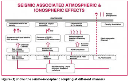
Early warning of earthquakes has actually become the main goal of seismology. And though seismic prediction started as a purely seismological discipline, it now involves hydrology, hydro -geochemistry, measurement of telluric and magnetic fields etc. The parameters under observations for the purpose of diagnosing seismic regimes include hydro -chemical parameters, atmospheric electrical disturbances, electromagnetic emissions, anomalous disturbances in the ionosphere and the magnetosphere recorded by satellite.

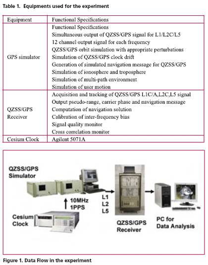
GPS modernization will expand the area of positioning service and will increase its convenience. Particularly, the third civil frequency namely L5, which will be provided by both modernized GPS and QZSS, is expected to improve the performance of precise positioning using carrier phase observation. This paper reports an experimental result regarding the convenience of additional L5 signal. Actual navigation signals generated from GPS simulator were received by triple frequency GPS receiver in the experiment. Navigation data, pseudo-range and carrier phase observation have been obtained and used for the analysis. This experiment verifies the improvement of ambiguity fixing time and multi-path mitigation using three frequency signals.


 (5.00 out of 5)