| Mycoordinates | |
Was there any pre-signal of Pakistan earthquake?
|
||||||||||||||||||||
| The authors have continued a research on the prediction of earthquake using GPS data in Japan, one of the disaster prone countries since 2000. The authors have discovered pre-signals of those past big earthquakes with more than M6, such as Miyagi Offshore and Hokubu Earthquakes (2003.5.26; M7.1 and 7.26; M6.4), Tokachi Offshore Earthquake (2003.9.26; M8.0), Niigata Chu-etsu Earthquake (2004.10.23; M 6.8) and Fukuoka West Offshore Earthquake (2005.3.20; M7.0) with use of “Electronic Control Points” or GPS stations constructed by the Geographic Survey Institute (GSI) as well as Sumatra Offshore Earthquake (2004.12.26; M9.0) and Pakistan Earthquake (2005.10.8; M7.7).
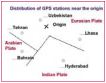
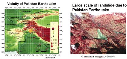
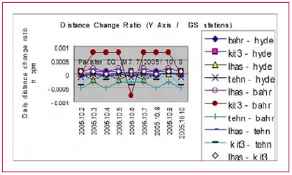
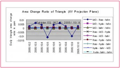
The authors have already reported the case of the Sumatra Offshore Earthquake in this magazine in July 2005. This time we would like to report the results of Pakistan Earthquake. Though the number of GPS stations of International GPS Service (IGS) near the origin of the earthquake was very few, the distance change ratio between Uzbekistan and Bahrain and the area change ratio of the triangle of Uzbekistan, Tehran and Lhasa showed pre-signals two or three days before the earthquake occurred. Distribution of IGS GPS stationsFigure 1 shows the location of the origin of Pakistan Earthquake. Figure 2 shows an example of large scale landslide occurred due to Pakistan Earthquake, which was taken by ASTER satellite. GPS stations near the origin were very few as shown in Figure 3. In this figure, the nearest GPS station is Uzbekistan (kit3) located in Eurasian Plate. Tehran (tehr) and Lhasa (lhas) are also located in the same plate. Bahrain (bhar) is located in Arabian Plate and Hyderabad (hyde) is in Indian Plate. The origin is located near the border of those three plates. Checking pre-signals before the earthquakeThe authors checked GPS data in the geocentric coordinate system from 10 days before to the day of the earthquake. The following two indicators were checked. 1) Daily distance change ratio in ppm; all combinations of distance between the five GPS stations in X, Y and Z axis. As shown in Figure 4, the daily distance change ratio in Y axis between Uzbekistan and Bahrain showed remarkable presignal on the 6th October 2005, two days before the earthquake. 2) Daily triangle area change ratio in ppm; all combinations of triangle consisting of three GPS stations out of the five GPS stations were checked. As shown in Figure 5, the triangle of Uzbekistan, Lhasa and Tehran showed the maximum change ratio in XY projection plane on the 5th October 2005. ConclusionsIt is obvious that there were pre-signals of Pakistan Earthquake in the indicator of daily distance change ratio as well as daily triangle area change ratio in GPS data as described in this report. The authors are honored to inform the readers that the Japanese Patent Bureau has approved our patent on “Prediction of Earthquake and Volcanic Eruption” (Patent No. 3763130) using GPS data as of the 27th January 2006. We will expect some businesses on the prediction of earthquake in Japan. Though we can discover pre-signals, we cannot foretell exactly when earthquake will occur. From our experience, two days at earliest to three months at slowest were critical days with red signal before earthquake. |
||||||||||||||||||||
|
||||||||||||||||||||
|


 (No Ratings Yet)


