
Indonesian military plane to map quake-hit areas
The Indonesian Defence Forces (TNI) have assigned a CN-235 airplane to carry out aerial photography on areas in the Yogyakarta region affected by 27 May 5.9-magnitude earthquake. The activity is aimed at making a detailed map of areas devastated by the quake.
TNI had also sent a Hercules C-130 plane carrying a TNI field medical team and three helicopters to evacuate victims. http://news.xinhuanet.com
june 2006
International Conference in GIS and Health
27-29 June, Hong Kong
chankw1@hkuoc.hk
http;//geog.hku.hk/HealthGIS2006
July 2006
ISPRS …
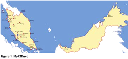
div class=”meta”>DATO’ HAMID ALI, AHMAD FAUZI NORDIN, DR SAMAD HJ ABU CHANG LENG HUA
The Department of Survey and Mapping Malaysia (JUPEM) is the competent authority in providing both horizontal and vertical survey control to the surveying community in Malaysia. This is carried out through the setting up of a surveying infrastructure throughout the country for the eventual purpose of national development, security and defence. In line with the government’s endeavour to improve its delivery mechanism, there have…
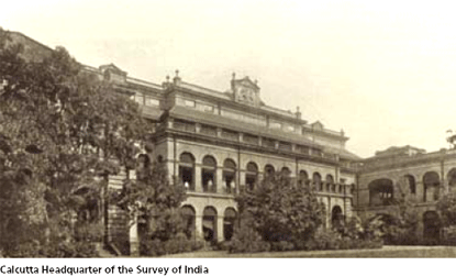
George Everest entered the Bengal Artillery as a Lieutenant on 4 April 1806 before he had even reached his 16th birthday. This rapid promotion was due to the number of vacancies at that time. Little has come to light about the first few years of his service in India until the siege of Kalinjar near Allahabad in 1812…
Conquering a technology is always important.
Owning it adds an arsenal to the might of the nation.
Hence, there is a …
A yen for regional navigation HIDETO (DUKE) TAKAHASHI
Rural infrastructure in India PAWAN KUMAR
SIRGAS – A geodetic enterprise LP FORTES, E LAURIA, C BRUNINI, W AMAYA, L S INI, AMA ANCHEZ, H DREWES,
W SEEMULLER
Bridging SDI design gaps HOSSIEN MOHAMMADI, ABBAS RAJABIFARD,
ANDREW BINNS, IAN P WILLIAMSON
Mine planning and design
PK BHATTACHARJEE

Limestone constitutes the predominant raw material for manufacturing clinker, which in turn is an intermediate product to produce cement. But if the deposit is not homogenous and the coeffi cient of variation (COV) of the main inherent radicals in limestone is very high then the consistency in the quality parameters of the product varies and so on the process requirements thereby affecting productivity. In such cases the deposit has to be understood statistically and a proper geological model should be designed to best fi t our mine design parameters. This paper deals in detail how surpac leads in solving a similar problem…
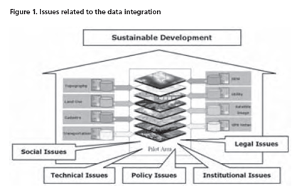
With applying modern technologies to generating spatial data, the amount of spatial data is increasing dramatically and huge amounts of data sets are being created and stored by different agencies.
Despite the growth of spatial datasets and the expansion of their use in different applications and new emerging services, they are being acquired and maintained by different organizations under different policies and even by organizations from different political and administrative levels. In such organizational arrangement, the spatial data providers produce and manage their own datasets without considering the reuse and integration of the datasets by other users, so most of the datasets have been produced and managed for a single purpose…
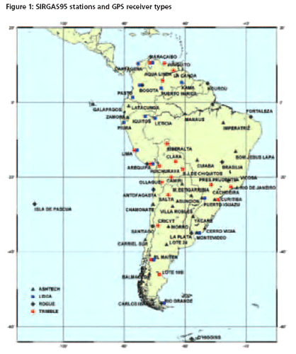
SIRGAS (Sistema de Referencia Geocéntrico para las Américas) is a joint project of South, Central and North American countries in cooperation with some international institutions for the establishment and maintenance of a geocentric reference frame for practical and scientific use. A unique reference frame for the American continent was established by two extremely successful geodetic observation campaigns…

US LBS market to grow to 1 million subscribers by 2010
Depending largely on the cellular operators actions, the US LBS business market is forecast to grow to from 582,000 to 1.1 million subscribed devices by the end of 2010, reports In-Stat. Location-enabled enterprise applications constitute a small but important segment of the market for mobile IT applications, the high-tech market research firm says. Applications for this technology include fleet management/dispatch, workforce and sales force management, as well as a variety of public sector location applications.
www.instat.com


 (5.00 out of 5)