
A nautical chart is a medium of information and tool for safe maritime navigation. It is the chief nautical instrument for ocean route planning and safe navigation. With the time not only the user’s requirements have increased, but also the advancement in the expertise in the field of nautical cartography has resulted in better product in the most useful way. With the advent of modern cartography, chart contents are stored in…
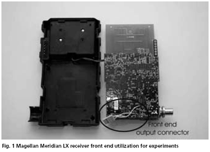
Many researchers and R&D laboratories in the world deal with the design of the software-based or experimental GNSS receivers using digital signal processing for work and experiments with received navigational signals. These concepts have one in common: the necessity of use of some analogue RF part before conversion of the signal to the digital domain. The problem of the RF front end design of the experimental or special purpose navigation receivers has to be solved. It is not an easy task as can be seen from many papers and conference contributions. The aim of this paper is analysis of the possibility of such GNSS RF front end design. We will discuss the following three main approaches
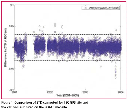
Atmospheric water vapour estimation from the GPS data, surface total pressure and the mean tropospheric temperature is the most cost effective method which gives all weather good spatio-temporal coverage. Precipitable Water Vapor (PWV) in the atmosphere can be estimated from GPS data by determining the travel time delay of GPS radio signals through the troposphere. Water vapour is already identified as…

An attempt is being made by volunteers all over the world to visit the confl uence points and document the scenery with pictures and narratives
Europe and Russia to restart talks on Galileo and Glonass operations
Negotiations on interoperability between the European Galileo and Russian Glonass satellite navigation systems are expected to restart soon, after a yearlong hiatus. The hope of talks follows an agreement on dialogue structures between the European Commission and Russia’s Federal Space Agency (FSA).
A trilateral steering board has been created for discussions between the EC, European Space Agency and the FSA. ESA already has working groups covering areas of co-operation under its framework agreement with the FSA, including satellite communications, global navigation and technology. These will include EC representatives and will report to the new steering board. A new working group on Earth observation will also be created.
www.flightglobal.com
Delhi faces confusion and chaos.
With a pressure to host Commonwealth games in 2010.
Unauthorized construction, encroachments, illegal …

Forest cover in Philippines on the rise
The Department of Environment and Natural Resources (DENR) revealed recently that satellite imagery and remote sensors indicate that the forest cover in Central Luzon has increased to 7.2 million hectares from 6.5 million hectares in 1988. www.manilastandardtoday.com

Transformation of GPS derived ellipsoidal height to orthometric height is one of the most important applications of gravimetric geoid. Its applicability remains questionable if the above transformation cannot be done to a reasonable order of accuracy. Use of GPS observations at levelling benchmarks and subsequently determined geoidal seperation using the geometrical relationship between geoid and ellipsoid (see fig. 1 )…

Border inspection mapping operation
China and Nepal will jointly launch a border inspection mapping operation. Both countries will apply GPS to survey the border marks. The major mapping work will be done by Chinese workers and then workers from Nepal will check the mapping data and results. The Surveying and Mapping Bureau of Shaanxi, from northwest China, has been appointed to take the task and will form the main body of the China team. The first batch of mapping workers are scheduled to arrive in the China-Nepal border area next month and all the outdoor surveying is planned to finish by the end of September. It is expected that the final mapping outcome will be unveiled by the end of 2007. www.vnagency.com.vn
Was there any pre-signal of Pakistan earthquake? SHUNJI MURAI AND HARUMI ARAKI
Optimizing gravimetric geoid solution
SK SINGH, BRIG B NAGARAJAN, PK GARG
Water vapour estimation at few GPS sites in Indian subcontinent SRIDEVI JADE AND MSM VIJAYAN
Design methods for RF part of GNSS software receivers PAVEL KOVAR, PAVEL PURICER, JOSEF SPACEK
Advent of modern cartography in nautical charting RB SINGH




 (5.00 out of 5)