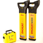
Leica Geosystems is delighted to announce the latest editions to their cable locator family, the Leica Digicat 600i and 650i series, accompanied with Logicat software, set to revolutionize underground cable location.
Building on the success of previous models, the new Leica Digicat 600i and 650i with their unique data capture and onboard memory function supports operations …

For the purposes of this paper, the vehicle was tele-operated from the nearby BS with the operator manoeuvring with the aid of three onboard video cameras and a display of the LiDAR data in realtime. Autonomous operation using the LiDAR data and was demonstrated in Whitty et al. (2010)(For videos, see our YouTube channel: www. youtube.com/UNSWMechatronics).

GPR is a geophysical investigation method. Its principle is similar to that of Seismics but instead of emitting elastic waves, it emits electromagnetic waves. They are much shorter, which leads to a much higher spatial resolution. GPR is sensitive to the electromagnetic properties of the material under investigation. Interfaces of rock formations, fi ssures and aquiferous areas are displayed.

Obviously, before any datasets can be compared or combined, they must be brought together onto the same datum (Janssen, 2009). The practice of transforming from one datum to another is not diffi cult and the necessary parameters are available in many different software packages. However, with the increased number of datums comes an increased number of ways to transform between datums.

The Global Spatial Data Infrastructure SDI Cookbook defines SDI as the “… collection of technologies, policies and institutional arrangements that facilitate the availability of and access to spatial data.” This definition (which predates the cookbook) is more than fifteen years old, and over the course of fifteen years much progress has been made toward the SDI vision of abundant, easily shared, easily used geospatial information.

The Spectra Precision business within Trimble had very rapidly assembled a portfolio of optical and GNSS surveying products. While Spectra Precision had in-house engineering, design and manufacturing capabilities on the optical side, the GNSS products had been sourced from a variety of external suppliers.
March 2012,
Munich Satellite Navigation Summmit 2011,
13 – 15 March, munich, Germany,
www.munich-satellite-navigation-summmit.org;


 (5.00 out of 5)