
Ordnance Survey to help Guyana reap the benefit of geospatial data
Ordnance Survey (OS) is to provide consultancy services to the Guyana Lands and Surveys Commission (GLSC) to re-establish and further develop the GPS Continuously Operating Reference Stations (CORS) network in Guyana. The project seeks to establish and sustainably maintain a modern, robust and accurate …
Virtual Surveyor streamlines workflow
The Virtual Surveyor drone surveying software now offers a faster, more efficient workflow and better overall user experience in a more stable platform. These new capabilities, along with an improved licensing system and an extended free application, are available now in Virtual Surveyor 6.
The software leverages the expertise and interpretation …
Singapore’s first 5G pilot network
Singtel and Ericsson are strengthening their 5G Centre of Excellence Programme partnership with the announcement of a new initiative that will see Singapore’s first 5G pilot network go live this year.
Using Ericsson’s 3GPP standardscompliant 5G technology with the trial spectrum allocated by Singapore’s Info- Communications Media Development Authority (IMDA), …
Beidou’s third-generation satellite navigation makes a splash
More than 40,000 fishing boats in China have been equipped with receivers tuned to China’s Beidou Navigation Satellite System, to provide better search and rescue for ships in trouble, a Beidou expert said. “Fishers call the Beidou system their patron,” Yang Yuanxi, an academician with the Chinese Academy …
Airbus wins two ESA studies for Mars Sample Return mission
Airbus has won two studies from the European Space Agency (ESA) to design a Sample Fetch Rover and an Earth Return Orbiter. These two elements will be critical parts of a mission to return samples of the planet Mars to Earth before the end of …
Stuart Woods
Vice President, Geospatial Content Solutions Division, Leica Geosystems AG.
How is Leica Pegasus: Two Ultimate different from its earlier version Leica Pegasus: Two?
The Leica Pegasus:Two Ultimate is an upgrade to the Pegasus:Two, Leica Geosystem’s trusted mobile mapping platform. With a focus on imaginary, it removes the need for multiple-camera stitching by incorporating a single …

In May 2016, Google announced the availability of GNSS raw measurements from Android 7. Since then, the developers can access carrier and code measurements and decoded navigation messages from mass-market devices.

Now a days more than hundred Global Navigation Satellite System (i.e. GPS, GLONASS, Galileo, Beidou, and IRNSS) signals are available everywhere all the time at free of cost. Hence, dependency on the GNSS technology has been…
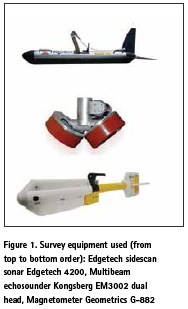
The purpose of this paper is to conduct the evaluation of the object detection using sonar and geophysical methods. Increasing interest in maritime archaeology has led to a growing need for measuring techniques or innovative methods..

Paddy is the third largest crop planted in Malaysia after oil palm and rubber. According to Paddy Statistics of Malaysia 2014 reported by Malaysian Department of Agriculture, nearly 679 239 hectares of land planted with paddy in Malaysia.


 (5.00 out of 5)