Articles tagged with: MILTIADIS CHATZINIKOS

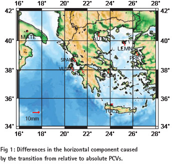
Positioning by GPS can be derived today with a precision of a few millimeters. A GPS receiver determines the distance between the electrical phase center of its antenna and the phase center of a GPS satellite’s transmitting antenna as a pseudorange or a carrier phase observation. It is well known that the phase center of the antenna is not a stable point.

The ionosphere represents one of the most important error sources that affecting GPS positioning. It is strongly related to solar activity and geomagnetic ?eld. The GPS satellites and dual frequency receivers can be used to measure the Total Electron Content (TEC) of the Earth’s ionosphere. Global electron content maps have been produced by various research centers using the world-wide permanent network of GPS receivers. In this study a rapid method of monitoring the ionospheric disturbance using dual frequency GPS data of the Aristotle University Thessaloniki (AUT1) permanent station is presented. The Total Electron Content can be determined using the so called Single Layer Model (SLM) of the ionosphere. The SLM is based on the assumption that all free electrons are concentrated in a spherical layer of in?nitesimal thickness (single layer) at height H above the earth’s surface. The Total Electron Content is modeled as a truncated Taylor series with the geographical latitude and the hour angle of the sun as independent variables, using the L4 – geometry free linear combination. The results are con?rmed using global information for Sun spot and geomagnetic activity from NOAA and Kyoto University respectively.


 (5.00 out of 5)