| Positioning | |
TEC values estimation over a permanent GPS station
|
|||||||||||||||||||
|
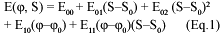
The ionosphere represents one of the most important error sources that affecting GPS positioning. It is strongly related to solar activity and geomagnetic ?eld. The GPS satellites and dual frequency receivers can be used to measure the Total Electron Content (TEC) of the Earth’s ionosphere. Global electron content maps have been produced by various research centers using the world-wide permanent network of GPS receivers. In this study a rapid method of monitoring the ionospheric disturbance using dual frequency GPS data of the Aristotle University Thessaloniki (AUT1) permanent station is presented. The Total Electron Content can be determined using the so called Single Layer Model (SLM) of the ionosphere. The SLM is based on the assumption that all free electrons are concentrated in a spherical layer of in?nitesimal thickness (single layer) at height H above the earth’s surface. The Total Electron Content is modeled as a truncated Taylor series with the geographical latitude and the hour angle of the sun as independent variables, using the L4 – geometry free linear combination. The results are con?rmed using global information for Sun spot and geomagnetic activity from NOAA and Kyoto University respectively. TEC estimation from GPS dataThe change in satellite to receiver signal propagation time due to the ionosphere is directly proportional to the integrated free-electron density in a column of one meter-squared cross-section along the signal path. Ionosphere consists of a shell of consists of a shell of ionized gas plasma surrounding the Earth between altitudes of about 80 and 1000 Km. In order to model the TEC parameter over the test area GPS data from our permanent station named AUT1 was used. The ionospheric model is a single-layer model at 350 km from the earth’s surface. The model makes the assumption that all the electrons are concentrated in a spherical layer at height H above the earth’s surface. The observable is the plain difference of the L1 and L2 phases (L1-L2, both expressed in meters), the parameters are the coef?cients of a two dimensional Taylor series development as given in equation 1 (the independent arguments are geocentric latitude and hour angle S of the sun) of the electron density of a single layer model of the ionosphere. Therefore for each session data an electron density containing ?ve parameters is written as follows:
where: S is the hour angle of the sun which de?ned as the angle between the sun and the local meridian. The local solar time t is related to the hour angle In October 2003 the GPS rinex data, with 30-sec sampling rate cut-off angle of 150 along with precise satellite orbits and clock corrections, was selected in order to generate ionospheric TEC data. The GPS data was processed with Bernese software and the parameters of equation 1 were estimated using a least squares algorithm (for more details see Wild, 1994). Global information for Solar and Geomagnetic activityDue to the dependence of the ionosphere on the solar radiation and the geomagnetic ?eld, ?rst the sun spot activity was examined using the relevant information of NOAA National Geophysical Data Center, which provides scienti?c products and services for geophysical studies. It is known that the solar cycle varies over a period of typically 11 years from trough to peak and then back to another low point. The conventional index of the cycle is known as the sunspot number (SSN) which is de?ned from observations of the sun by optical telescopes and can be used as a predictor of ionospheric disturbance. The increment in sunspots induces a series of solar ?ares and coronal mass ejections. Solar ?ares are explosions on the surface of the sun that produce a quick directed high-speed blast of charged particles and electromagnetic energy. The SSN numbers of October 2003 are presented in Figure 1. As it is clearly shown the days from 14 to 16 are characterized as quiet with SSN less than 20, while for 27 to 31 the SSN is over 160, which means storm event. In order to have the best possible global information about the ionospheric activity we have also investigated the magnetic conditions using the available information from the Data Analysis Center for Geomagnetism and Space Magnetism of Kyoto University in Japan. Variations in Earth’s magnetic ?eld are measured by magnetometers. There are two measurements readily available from magnetometer data, the daily A index and the three-hour K index. The A is an average of the eight 3-hour K indices, and uses a linear scale and going from 0 (quiet) to 400 (severe storm). The K index uses a quasilogarithmic scale (which essentially is a compressed version of the A index) and goes from 0 to 9 with 0 being quiet and 9 being severe storm. Generally an A index at or below 15 or a K index at or below 3 is best for propagation. As the K values increase, the severity of the storm increases. Figure 2 illustrates the state of geomagnetic conditions (Kp index, p stands for planetary) for the days of October 2003. Same results with ?gure 1 are shown
especially for days between 28 to early of 31 where the geomagnetic activity was very high and reached at its maximum value of 9. From many researchers these days have been Days of month characterized as one of the most exciting space weather events in recent history. For comparison purposes and in order to better understand the event and its impact on GPS positioning we produced two ionospheric maps for the broader area of Thessaloniki where the permanent GPS station is located. All the maps were generated using the Generic Mapping Tools. The ?rst map is for the 16th day of October on 10 UT time which in general is under quiet geomagnetic and solar activity with SSN number almost 20 and Kp index less than 4. We processed every one hour the GPS data and the produced results are illustrated on ?gure 3. It is clearly shown that the ionospheric conditions are at very low order of magnitude with TEC values (at 10 UT) between 13.35 to 13.39 TECU (TEC Units). On the contrary, during intense storm conditions with SSN 170 and Kp equal to 9 as it was expected, TEC values for the 29th day of October at 10 UT are over 5 times bigger and reached 67.6 TECU. For these geographic latitudes (40- 42N), TEC values greater than 50 TECU re?ect the enhanced storm phenomena associated with large gradients and high ion ?ux values. Figure 4 illustrates the TEC values in the broader area of the permanent station where also a different spatial variability- plume is sparsely shown. ConclusionsIn this study a rapid method for monitoring ionospheric variations using data from only one permanent GPS station is presented. TEC data are estimated using the iono-model of single layer where dual frequency GPS data are used in a least squares procedure. The model was found to be adequate during quiet and storm conditions, which indicates that, for surveying applications in the vicinity (up to 100 Km) of permanent GPS tracking stations, the ionosphere models distributed by the permanent station are suf?cient for use. TEC maps are produced with time resolution of one hour, which is a rapid scheme of knowing space weather conditions. Therefore a user can be quickly informed whether a day is characterized by a high ionospheric activity for GPS signals, in order for him to better handle the corresponding errors. Also, knowing space weather conditions in a short time interval can be found useful for telecommunication systems, as well as navigation systems. Furthermore, more reliable ionospheric results using more sophisticated models for bigger areas or countries can be produced, if data from several GPS receivers, being part of permanent networks, combine. ReferenceChatzinikos M. (2005): Study of TEC variation of the ionosphere using GPS measurements. Diploma Thesis, Department of Geodesy and Surveying. Aristotle University of Thessaloniki, Greece. Contadakis M, Arabelos D, Asteriadis G, Pikridas C and S. Spatalas (2004): GPS monitoring of Ionospheric TEC over the area of Thessaloniki in order to detect disturbances related to the local tectonic activity. Geophysical Research Abstracts, 1st General Assembly of EGU Nice, France, 25 – 30 April. Dermanis A. (1999): Space Geodesy and Geodynamics. Aristotle University of Thessaloniki, Editions Ziti, Greece. Doherty P, Coster A and Murtagh W. (2004): Space weather effects of October-November 2003. GPS Solutions, vol. 8, No. 4, pp. 267-271. Fotiou A. and Pikridas C. (2006): GPS and Geodetic Applications, Aristotle University of Thessaloniki, Editions Ziti, Greece. Georgiadou, Y. and Kleusberg A (1988): On the effect of Ionospheric Delay on Relative GPS Positioning. Manuscripta Geodaetica., Vol.13, pp. 1-8. Hugentobler U., Dach R., Fridez P., Meindl M. (2005): Bernese GPS software version 5.0. Astronomical Institute, University of Bern, Switzerland. Mannuci AJ, Wilson BD, Yuan DN, Ho CH, Lindqwister UJ, Runge TF (1998): A global mapping technique for GPS-derived ionospheric total electron content measurements. Radio Sci. 33:565-582. NOAA Satellite and Information Service/National Geophysical Data Center, http://www.ngdc.noaa.gov Pikridas C. and Fotiou A (2003): Evaluation of the effect of ionospheric refraction on relative GPS positioning: Application in the broader area of Thessaloniki using GPS permanent station data. Tech. Chron. Scienti?c Journal of TCG, No 1-2, pp. 57-65. University of Kyoto, World Data Center for Geomagnetism. http:// swdcdb.kugi.kyoto-u.ac.jp Wessel, P. and Smith, W. H. F. (1995): New version of generic mapping tools released, EOS Trans. Amer. Geophys. U., 76, 329. Wild , U., G. Beutler, W. Gurtner, and M. Rothacher (1989): Estimating the Ionosphere Using One or More Dual Frequency GPS Receivers, Proceedings of the Fifth International Geodetic Symposium on Satellite Positioning, Las Cruces, New Mexico, Vol. 2, pp. 724-736, March 13-17. Wild, U (1994): Ionosphere and Geodetic Satellite Systems: Permanent GPS Tracking Data for Modeling and Monitoring, Geodatisch-geophysikalische Arbeiten in der Schweiz, Vol. 48. |
|||||||||||||||||||
|
|||||||||||||||||||
|


 (No Ratings Yet)


