
Carlson Software releases Carlson iCAD 2019
Carlson’s specialized drafting package, Carlson iCAD 2019, has just been released. The software allows technicians to supplement the finished product in their project deliverables.
New additions and functions to the iCAD 2019 release are new tool palettes, new 3D solid commands, additional DGN support, and new express tools. iCAD features Google …
Enugu govt partners World Bank on GIS-based road mapping
ENUGU State Government has said it is partnering with World Bank on GISbased road inventories and mapping for easy identification of rural road and economic development. Ifeanyi Ugwuanyi Project co-ordinator of Rural Access and Mobility Project, RAMP, ll, Chief Chinedu Ugwu, who revealed this at a stakeholders’ …

Dr Gladys West inducted into Air Force Pioneers Hall of Fame
An 87-year-old doctor whose programming of accurate earth models led to the current GPS system has been inducted into the Air Force Space and Missile Pioneers Hall of Fame. Dr. Gladys West was presented with the Air Force Space and Missile Pioneers award for her …
Droneshield join hands with Thales
DroneShield has entered into a Teaming Agreement with Thales Programas De Electronica Y Comunicaciones S.A.U. (“Thales”) (a Spanish subsidiary of Thales S.A.), whereby Thales will utilise and promote DroneShield’s products in its defence and security contract bids in Spain involving counterdrone aspects.
Drones help map sea level rise
Drones can be used to …

Says Prof Bradford Parkinson, Chief Architect for GPS and PNT Advisory Board 1st
Vice Chair while discussing the Ligado proposal. He shares his views on the wide
range of issues related to GNSS in an interview with Coordinates magazine

As we anticipate technology trends unfolding in 2019, the dominant theme for the geospatial industry is the need for precise data…

This article focuses on the technology of creating a digital elevation model (DEM) with the help of the geographic information system (GIS)…

Navigation should be de defined not only “to move from point to point decided” but also “entirely to establish the decided Mission including…

Volume XIV, Issue 12, December 2018
Zip
From oral agreement to distributed agreement: digital ledgers in land registration
Mohsen Kalantari, Xueling Chen, Zhouyang Wang, Luan Nguyen
Geo-Information tools, governance, and wicked policy problems
Yola Georgiadou, Diana Reckien
CORS usage for GPS survey in Greater Accra region: Advantages, limitation and suggested remedies
Surv. Sebastian Botsyo (MGhIS), Bernard BORKETEY BORTEI, John AYER
Spatial heterogeneity, scale, …
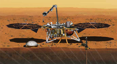
InSight lander
On 26 November 2018
Humanity achieved another milestone
When InSight lander successfully landed on Mars.
Launched on 5th May 2018
It not only intends to study the deep interiors of the Mars
And evolutionary processes
but also the possible seismic activity there.
However, the mission gets an unexpected breakthrough
When it is said to have recorded the sounds of wind
On 1 December …


 (5.00 out of 5)