
Dr Naser El-Sheimy is Professor at Department of Geomatics Engineering, at the University of Calgary. He holds a Canada Research Chair (CRC) in Mobile Multi-sensor Systems and the scientific director of Tecterra Research Centre. His research expertise includes GPS/INS integration, multi-sensor systems, and mobile mapping systems. Prior to joining the University of Calgary, Dr. El-Sheimy …

Geomatics is the art and science of measurements on the surface of earth including what is below the earth and in the oceans. This is the simplest form of definition; more exact and elaborate definition has been produced by FIG¹. In other simple words Geomatics is the new terminology for the centuries old profession of Surveying and Mapping…

Edited by Abbas Rajabifard
ISBN 978-0-7325-1620-8
Published by Centre for SDIs and Land Administration,
Department of Geomatics,
The University of Melbourne
Towards a Spatially Enabled Society
‘Spatially enabled government’, ‘spatially enabled society’, ‘spatially enabled’…… These are terms which we are …
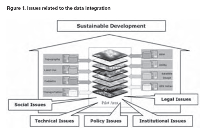
With applying modern technologies to generating spatial data, the amount of spatial data is increasing dramatically and huge amounts of data sets are being created and stored by different agencies.
Despite the growth of spatial datasets and the expansion of their use in different applications and new emerging services, they are being acquired and maintained by different organizations under different policies and even by organizations from different political and administrative levels. In such organizational arrangement, the spatial data providers produce and manage their own datasets without considering the reuse and integration of the datasets by other users, so most of the datasets have been produced and managed for a single purpose…
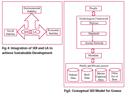
Spatial information plays important role in the development of the social, economic and environmental sectors. Some of the most remarkable applications for geographic information include: crime management, terrorism prevention, land and business development, flood mitigation, and disaster recovery (SDI Cookbook, 2004)…
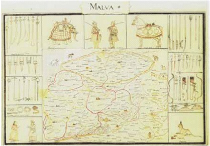
Raja Todarmal was the minister for revenue in the court of Akbar. Building upon the foundations laid by Sher Shah, Todarmal introduced a system of land reforms, the essence of which was an assessment of the land revenue according to the extent of cultivation, the nature of the soil and the quality of the crops. He set up a scheme of laborious measurement, analysis of possibilities and calculation of prospects…

Spectra Precision Laser grade control systems
Trimble has introduced a portfolio of laser-based machine display and control systems for grading and excavating applications. The new Spectra Precision Laser machine systems is said to be highly fl exible, extremely rugged and can be used on a wide range of machines, including dozers, backhoes, scrapers, skid steers and excavators. On a dozer, the system can be upgraded for automatic blade control providing even greater productivity gains. The Spectra Precision Laser grade control systems give the operator visual guidance for the cutting edge of the blade or bucket.
www.trimble.com
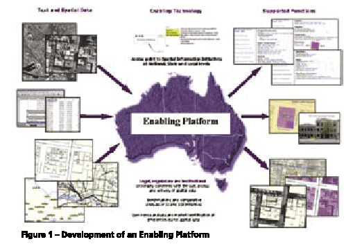
Users of positioning and spatial information services and tools require precise spatial information in realtime and real-world objects. Simply an accurate positioning of a future subdivision is no longer accepted, users require it to be visualized as well, in order to take into account outside in?uences. The capacity to meet such user needs and deliver services and tools within the spatial information market has gone beyond the ability of single organisations (Rajabifard, et al, 2005a). There is now a wide range of products and services available for a wide range of IT applications, and hence the development of an enabling platform can facilitate access to data and sharing resources and tools among different practitioners. The creation of an enabling platform for the delivery of these tools and positioning applications will allow users from diverse backgrounds to work together with current technologies to meet the dynamic market place.
USGS experts responding to two major natural hazards
As U.S. Geological Survey staff prepare for Hurricane Milton to hit Florida’s west coast, agency experts are still dealing with the after-effects of Hurricane Helene that made landfall in Florida late last month and continued a path of destruction north through Georgia, North Carolina, South Carolina and Tennessee.
While …

Alexander’s critique of modern architecture is not only a call for reform within the architectural discipline but also a blueprint for rethinking urban management.
Bin Jiang
LivableCityLAB, Thrust of Urban Governance and Design, The Hong Kong University of Science and Technology (Guangzhou), China
Christopher Alexander argued that modernist approach to architecture prioritizes innovation, abstraction, and mechanistic efficiency at …




 (5.00 out of 5)