
In this paper, I would like to discuss the current situation of the working environment for young surveyors based on the contents of such reports…

Survey Department, under the Ministry of Land Reform and Management, is the National Mapping Organization (NMO) of Nepal. The Department is responsible…
The number of people living in informal settlements around the world is difficult to measure precisely, but some estimates put it at close to one billion, or almost one…

Nasarawa State is one of the thirty six (36) federating states of Nigeria. It was created in 1996 and is located in the north central part of the country…

The Statement 1 of the FIG Brochure ‘Cadastre 2014’ stipulates Cadastre 2014 will show the complete legal situation of land including public rights and restrictions.


The 1960s to early 1970s were boom times for enrolments in surveying and geomatics programs in the state of NSW in Australia and I suspect other states as well. At the University of NSW (UNSW) at that time there were up to 100 students per year entering the program.

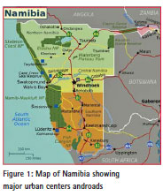
This study investigates the potential of using Unmanned Aerial Vehicles (UAV) in surveying and mapping customary land parcel boundaries. In Namibia, new laws demand for the boundaries of individual and collective customary lands to be adjudicated, mapped and recorded…
The Open Geospatial Consortium (OGC) membership has approved the OGC Web Processing Service (WPS) Version 2 Interface Standard. It provides rules for standardizing how inputs and outputs….

The rapid development and increased demand for spatial information infrastructures in many jurisdictions have made spatial information an invaluable tool in policy formulation and evidence-based decision making.


 (5.00 out of 5)