| SDI | |
SDI: Lessons from Nasarawa state experience
Nasarawa State Government, Nigeria embarked on a large-scale land-based investment of US$16,876,561.00(2.7 billion Nigerian Naira), using modern geospatial technologies to develop a modern geospatial data infrastructure for the state |
 |
|
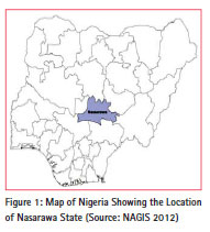
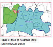
Nasarawa State is one of the thirty six (36) federating states of Nigeria. It was created in 1996 and is located in the north central part of the country. It is bound by the Federal Capital Territory (FCT), Abuja to the west, Kaduna and Plateau States to the north, Taraba State to the east and Benue and Kogi States to the south (See Figures 1 & 2). It has a total land area of 27, 290sq km. with a population of over two million people, where most of them practice subsistence agriculture.
Presence of naturally made land is a very important resource to the government and people of the state. In this context, the proper management of land in the state is imperative. Its close proximity to Abuja, FCT (See Figure 2) has made the state to always react to events that it has no control over. Development activities within Abuja, FCT in the last 38 years has significantly affected in Nasarawa State. Most of the impact has been on land and could be said to always be negative in a lot of cases. For instance, a large number of the FCT’s work forces are resident in the neighboring Karu Local Government Area of the state. Though no reliable official figures are available, various estimates put the figures at between 45% and 50% of the FCT work force living in Nasarawa State and commuting daily. This has multiple effects on housing needs, transport and other social services. Past administrations of the state have unfortunately not been able to address land issues within the entire state. Land and important means of production were completely ignored until the year 2012.
The state government realized early in 2011 that the entire system of land administration and management within the state was in chaos. Records available within the lands department are old and not easily retractable if and when needed. Under this scenario it was easy to see that no meaningful development could be achieved without putting in place a modern system that could address the serious issues in a holistic manner once and for all. In addition to this the state government was (and is still) in a precarious financial situation. It could not depend on the federation account allocation for its sources of funds if it wants to serve its people properly. Due to this issue, the state government decided to look inward and harness the land resources at its disposal. It decided to embark on a large scale land-based investment of US$16,876,561.00(2.7 billion Nigerian Naira), using modern geospatial technologies in order to develop a modern geospatial data infrastructure for the state. The project has three components – Orthophoto Mapping, Geographic Information Service and Urban Planning & Urban renewal, commenced in May 2012.
Under this project, the state land mass of 27, 290sq km was flown. Six townships were flown at 10cm GDS, while the remaining parts of the entire state were flown at 25cm GDS. The data acquired were stored in a GIS platform of Nasarawa Geographic Information Service (NAGIS). Land use and land cover maps were also produced for the entire state. This is an unprecedented development as not more than one state in Nigeria has performed such a feat so far.
This paper essentially set up to examine the impact of this large scale land-based investment by the state government:
– The development of spatial data infrastructure in the last two and half years as well as the challenges faced during the implementation stages. Lessons learnt so far as well as the remarkable improvement in service delivery recorded in land administration and land management practices are unprecedented.
Project overview
The development of spatial data infrastructure in the state – known as Nasarawa Development Platform Project – was conceived to address the many issues of Land Administration and Management within Nasarawa State. The sharing of a common border with Federal Capital Territory (FCT) and Abuja City makes for a strong case for addressing squarely the problem of urban poor in respect of land ownership and its attendant social consequences. This project has three components:-
• Digital Aerial Mapping of the Whole State and Six selected Urban Areas Nasarawa Geographic Information Services (NAGIS).
• Urban Renewal & Planning of three Townships (Lafia, Keffi& Karu)
Commenced in May 2012, the project spilled over to the year 2015 even though it had an initial completion period of 24 months at a total cost of UD$ 16,876,561.00.
Existing situation before the NDP project
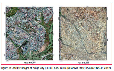
All the major townships of Nasarawa State suffer from lack of proper planning and near total neglect of the environment. It would be an understatement to say that all of them are a mess and Karu area suffers most – unstructured with a lot of economic potential that are untapped and completely neglected. Poverty is so glaring in this area and almost near similar situation is replicated in most of the state’s townships. This is in sharp contrast to the well planned environment of its immediate neighbor – Abuja City (See Figure 3).
The area is characterized by large scale acquisitions by private individuals as well as cooperate organizations. This is a direct consequence of the areas’ close proximity to Abuja City. Almost all these developments were not based on any plan nor were they ever regulated or coordinated by either the Town Planning Department of the MLUD or the Nasarawa State Urban Development Board (NUDB). Most of these developments or properties do not have any record in any of these government agencies. Where there are records, the agencies lack the technical competence and equipment to monitor and enforce compliance of building codes and or regulations. As a result of this gap, the area is now characterized by unplanned and unregulated (in some cases squatter) settlements with all the attendant environmental hazards that go with such areas (see Figures 4 & 5).
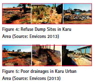
Within these areas there is also lack of proper drainage systems and where they are available, garbage is dumped in them. This blocks the free flow of storm water and increases the risk of flooding during the wet season (see Figure 5).
There is also the preponderance of large numbers of small and large scale farm holdings from both indigenous farmers of this area and from different parts of the country. Farming is a primary economic activity of the people. The gradual takeover of such lands for housing and commercial development from such people is a major concern that is already posing a problem for the people and state administration. A lot of the farmers have been forced to become tenants on their own lands, having sold the same to more affluent people who were attracted to the area because of its proximity to Abuja City. Some have become farmers without farm land thereby increasing the level of poverty in the area.
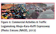
Since the commencement of physical development within the FCT in the early 1980s, physical and unplanned development within Karu axis has been going on in several directions at an alarming rate. However the most significant areas and direction of growth are along the major highway of Abuja – Karu – Keffi. This has led to traffic grid lock particularly right from the boundary of the FCT through Mararaba to Masaka area (see Figure 6) all year round, despite the two-lane highway.
The vision of the state government is to develop the area as a twin city that can compete favorably with Abuja in terms of all the social and economic activities. This vision cannot be achieved without a reliable and up-to-date spatial data infrastructure in place. The Nasarawa Development Platform program is therefore a conscious and well planned attempt in setting up a modern spatial data infrastructure aimed at addressing these challenges in a holistic manner for short and long term benefit to the people and state government.
It is important to note that a real gap existed for long in the state regarding land titling. Very few people and corporate organizations have real title documents to their holdings despite the fact that the state has a long history of land title (records of the 1930s are available in the archives of the State Ministry of Lands). In cases where such titles to land holding are found, they are mostly in the township areas of Karu, Lafia and Keffiin that order of importance. Other township areas include Nasarawa and Akwanga.
A lot of the people have customary titles much of which are undocumented. Very few property owners hold statutory title to land. Many have no certificate of occupancy evidencing their grant and or holdings. A certificate of occupancy is an instrument that can be registered in Nigeria and an evidence of a grant for a right of occupancy. It is the only title document that almost all financial institutions accept as collateral in order to secure a mortgage. It is therefore easy for one to see why the lack or absence of such documents could be a major source of concern not only for the state government but for other stakeholders, particularly financial institutions willing to invest or borrow money to real estate developers.
There were similar attempts to address these challenges in the past, but all failed due to lack of strong political will and technical know-how. This project is the first major attempt by the state government to address the issue of proper land records in a wellstructured GIS database that would be easy to retrieve if and when needed. It came when the government understood its importance and became willing to invest and support the investment to fruition. It came because the government is showing strong political will knowing fully well that this would also assist her in taking decisions from an informed position as well as provide the basis for titling which would not only ensure security of tenure for the poor and the not so poor alike, but also assist the government in harnessing the much needed but long neglected land revenue.
Digital aerial mapping of the state
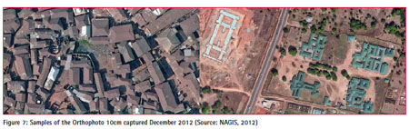
A significant milestone was attained on December 28, 2013 when flying of the entire land mass of the State was completed, making Nasarawa the first state in Nigeria to achieve such a historic goal. So far all the six (6) townships areas have been flown at 10cm resolution which led to the production of Orthophoto maps and 1 m contour lines. (See Figure 7 for the samples of the 10 cm images).
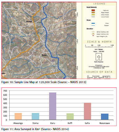
Linemaps & land covermaps
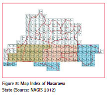
Figure 8 is the index map of the entire Nasarawa State. This project has produced land cover and line maps of the entire state for both official use and any other use by private citizens.
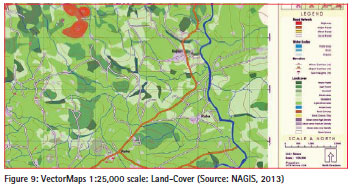
These maps are at the scale of 1:25,000 (See Figure 9 for samples).
This is a significant achievement if viewed from the fact that nothing of this nature ever existed in the state. Most of the available topographical and cadastral maps were very old and mutilated and most often not very useful.
Pilot project of roof count using orthophoto
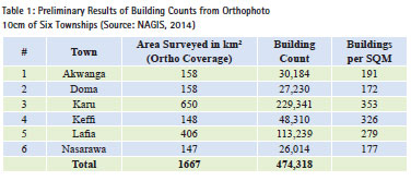
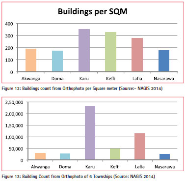
Using the 10cm Orthophoto of the six townships, the project was able to conduct a pilot study of rooftop count of existing buildings/properties. This led to actual identification of the extent of most of the urban sprawl areas which is now giving us a more refined figure per square kilometer. It is also giving us an accurate identification of the slum area, local business districts, other areas of interest, major land marks etc. within these urban areas. Plans are under way to share this information with the National Population Commission to assist them in future planning and combining of data sets for useful government services. Preliminary results (see Table 1) have given us up to 474,318 buildings spread over an area of 1,667 sq km in the six townships.
The next stage is to use the data in population estimation. It is believed that a near accurate population figure could be obtained for these townships and ultimately for the state after a careful study and collaboration with the National Population Commission. Figures 11, 12 &13 give a graphic idea of the preliminary results of the building counts from the orthophoto.
Pilot project for rural cadastral and conservation
These images would help in setting up a Rural Cadastral System for the state as well as establishing Regional Development Plan for sustainable planning. Recently we started exploring the possibility of partnering with the Federal Ministry of Environment in respect to the REDD+ program. Using our Orthophoto we were able to produce a sample land use map of one of the old forest reserves that is under threat and would therefore need more serious conservation efforts. (See Figure 14 &15).
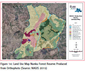
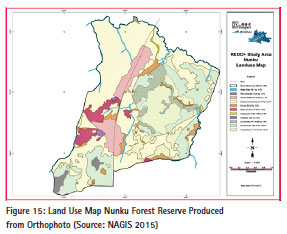
This collaborative effort would go a long way to assist in the global fight against climate change by identifying forest reserves across the state that are under serious threat as a result of unsustainable human activities.
We are also assisting the State Agency in charge of the Millennium Development Goal (MDGs) by mapping all the areas of their activities across the state. This is part of the effort towards development of GIS-based Land Information System (LIS) and development of a reliable rural cadastral for sustainable development in the state.
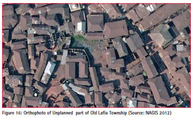
Urban planning & urban renewal
This component of the project is addressing the following issues:-
• Existing unregulated, unplanned settlements and the environment,
• Squatter settlements in Karu Area (and other Townships of the State), and
• Lack of infrastructure that has for long been a source of concern to the people. (See Figure 16).
This would aid the state government’s efforts of Urban Renewal Plan, General Land Use Plan and Development Control Capacity. As earlier seen, the proximity of the state with Nigeria’s new Federal Capital Territory has led to massive development of urban slums in Karu area.
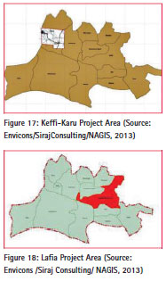
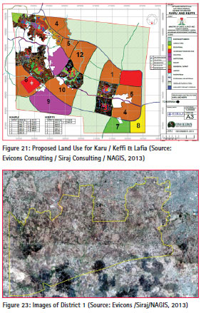
Draft final reports of Karu/Keffiand Greater Lafia areas were submitted by the Consultants in October 2013. These reports were based on survey conducted by the consultants as well as detailed appraisal and analysis of existing development based on mapping information, Orthophoto images and satellite imagery. This was done from middle of 2012 to the end of 2013. This report covers Draft Detailed Land Use Plan, including the proposed development plans and the draft Final Land Use Plan & Detail District plans including Urban Renewal and Upgrading Scheme. From these reports, the planning concept was laid out by the planners in line with the vision of the state (See Figures 17 & 18).
Urban renewal
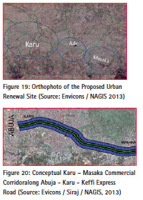
This aspect addresses the issues of urban poor because most of the areas slated for renewal are populated by them. Past neglect by the government is a contributing factor to the constant unprecedented growth rate in these areas. The consultant’s report laid a broad view of the Urban Renewal Master Plan of Karu, Keffiand Lafia area. From the report it is clear that the population of Karu area would continue to increase beyond 205,477 (recorded in 2006 National Census). Already the 2011 projection is put at 254,175 [at annual growth rate of 4.7% (Envicoms Team, 2013)]. (See Figure 19).
Other towns that make up the urban area of greater Karu are Mararaba, Ado, New Nyanya, Masaka and Auta-ba-lefi. All these areas are slated for urban renewal program (See figure 19). The proposal has spelt out details and methods of how the program will progress. It is however significant to note that the problems have been brought to focus and placed as a priority that deserves prompt attention of the government even if there is no immediate funding.
Commercial activities
Part of the submission also proposed a commercial corridor along the existing Abuja – Karu – Keffihigh way. This is significant because of the haphazard and unregulated commercial activities that are taking place here. Most of the urban informal sector activities of small scale traders, artisans, hawkers, etc., carry out their businesses on the side of the major highway of Abuja – Karu – Keffi. This in turn, led to the occupation of the road shoulder as well as the outer lane of the highway, thereby leading to constant traffic gridlock almost all day long. This no doubt is always a source of concern to commuters and the government (See Figure 6). To arrest the situation a commercial corridor was proposed and it will stretch from Karu to Masaka, a distance of about 10 km (See Figure 20). The concept is to provide ‘articulated development along a highly viable city suburb axis’ (Envicons 51, 2013). Some of the features of this development corridor include:
• ‘A central highway with a right of way of 200 m. A 100 m bus and rapid transportation for mass transit – to and fro carriageways to be completely separated, 50 m each way for the vehicles,
• Bus stations at district/ sector centers, and
• Interchange to link to and fro outer carriage way.
District planning
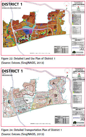
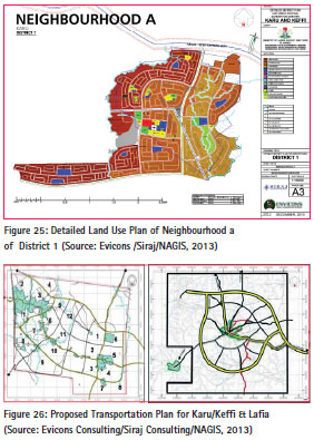
This project would select 11 districts for detail planning. Greater Karu has 5 districts, GreaterLafia and Keffi, 2.The draft final report has provided 12 districts in Karu, 8 in Keffiand 17 in Lafia for selection. Details can be seen in Figure 21. The criteria to be applied in delineation would include land use and uncommitted spaces, population concentration, administrative and cultural boundaries, natural and man-made boundaries, nature and character of economic activities as well as committed and legal sitesby government and their agents. A sample selection of District 1 in Karu area (Figures 22 & 23) gives details of the facilities that would be provided if and when the plan is finally implemented. It is also worthy of note that each district is further subdivided into smaller neighborhoods with detailed land use for proper implementation.
The report has been studied and would soon be passed into law for proper implementation by the state government. This is to ensure peoples participation in what is most likely going to affect their living conditions. However, it is significant to note that the proposal has taken care of creating some industrial areas in order to attract investors from within and outside Nigeria. This would no doubt create employment opportunities to the people, particularly the youth and reduce poverty, crime rate and the added insecurity. Agricultural development is crucial to the state. So agro allied industries would also go a longway towards solving the problem of ford security. Above all, these plans would assist tremendously in increasing their venue base of the state.
Transportation plan
This is a key component of the land reform program of the NDP project. The new proposal has taken care of this adequately. This is worth noting in view of the persistent traffic gridlock in Abuja- Karu– Keffiroad and constant loss of manhours. This is no doubt the busiest road in the whole state. Accordingly construction of two parallel by-passed, one on each side of the Karu–Kefficorridor has been proposed. This is in line with the vision of the state government. Once this is done, it would reduce the amount of time that is constantly wasted on the existing highway, open up new areas to orderly development and generate more economic activities that would in turn put more money into the pockets of the low income and increase the revenue base of the state through taxation.
Apart from the above, there is also the proposal for the extension of the Abuja Rail line to Keffiknowing fully well that most residents of Greater Karu work in the FCT. This makes it necessary for daily commuting and so a rail extension would fit perfectly and assist greatly to ease a lot of travel stress. Details of the proposal can be seen in Figure 26.
General features
It is important to highlight the most prominent feature of this report and proposal. We are already aware of the existing settlements particularly in Greater Karu area. It would not be feasible to think of uprooting the entire settlement in order to create a well planned environment that is eco-friendly. To this end the basic concept is that of integration of existing settlements without compromising quality of the environment. To achieve this, a gradual program of upgrading to improve the quality of building and its environment has to be adopted. ‘The whole city’ would be organized to‘graduate from the household to the cluster, neighborhood, district and sectors. Each level of residential organization is to be given its appropriate complement of services to meet its threshold demands.’ (Envicons Report, 2013, p. 35).
Similarly commercial activities would be regulated and developed in hierarchies, starting from a neighborhood centers through district centers up to a central area where highest order of commercial, administrative/cultural functions would be located. There would also be a good network of transport organized in hierarchy. The express ways would be the highest and the local access roads at the lower rung. There would also be pedestrian walkways that would ensure safety of the people. Above all, these proposals are intended to be carried out in phases over a period of 30 years.
Nasarawa geographic information service (NAGIS)
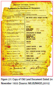
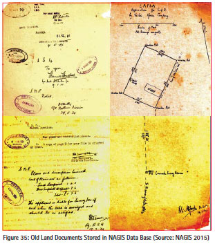
Is important to note that the State Ministry of Land has a rich record of land documents dating back to the colonial time when modern land administration was first introduced by the colonial administration in Nigeria. Records from the existing land files in the Ministry covers from those of old Northern Nigerian Government which was later transferred to the old Benue Plateau State in 1966, then transferred to Jos with the creation of Plateau state in 1976. Nasarawa State inherited these old records in 1996 when the state was separated from the old Plateau State. Accordingly the earliest land records and survey activities dates back to the early part of the last century. Records are available for documents of 1933 in the land archive. (See Figure 27).
In establishing NAGIS all these records were captured into the NAGIS database.
Land data capture
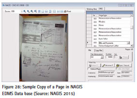
By the end of the year 2014 over 25,178 files were captured into the Land Information System (LIS) of NAGIS, while 24,205 of the above figure were captured into the Electronic Document Management System (EDMS). Of these files, 21,838 are linked directly to the LIS. These 24,205 files totaled up to 628,503 pages scanned into the EDMS with over 368,029 pages properly renamed and indexed for easy reference (See Figure 28).
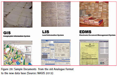
More than 90% of the data captured have undergone proper data clearing exercise and quality control. This gives a reliable database with high integrity. This is an essential element in obtaining public confidence when services are being delivered to them by the service agency. With this development, the state has now developed a well-structured spatial data infrastructure of international standard that can stand the test of time in delivering services according to world best practices. All documents are now accessed from the database. Paper maps are scanned and stored in a GIS, while other land documents are now in the LIS and EDMS (See Figure 29).
Land titling
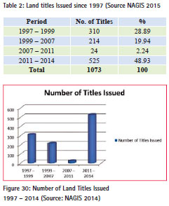
About 1073 titles to land were granted since the creation of the state 19 years ago. The first two years (during a military administration) witnessed the issuance of 310 titles (or 28.89 %). The next eight years of civil administration witnessed 214 (19.94%).
This followed a period of stagnation between 2007 and 2011, when only24 title documents were issued – a mere 2.24%. However in the last three and half years, an unprecedented 525 titles (48.93%) were issued using the new NAGIS database (See Table 2 & Figure 30). This became possible because of the increase in speed and efficiency when the LIS, linked to the GIS became fully automated in October 2013. From this period, NAGIS systems processed all new applications for Right of Occupancy (RofO) and produced all bills, with the Ministry of Lands and Urban Development (MLUD) standing down all manual operations.
There is also a corresponding increase in the number of new applications requesting for the issuance of title documents. In the year 2014 the number of new applications almost hit 1,000 (See Figure 31).

This is good omen for the property market and a positive step for the people and state.
Revenue generation
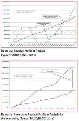
Before the commencement of this project, very little was collected from land charges, rents or taxes. Revenue from land contributed only 1% of the state’s internally generated revenue (IGR). A combination of Ground Rent, Development Fees, Registration Fees, Premium on Certificate of Occupancy and Application and Processing Fees as well Consent Fees for various transactions on land were what constituted land revenue earlier. It was difficult to collect such revenues in the absence of reliable and easy to access land records. The development of this spatial data infrastructure made it easy for the state to pull together all the records in one central database. This in turn led to an instant and dramatic increase in the amount of revenue generated and collected in the last two to three years when this project started its operations.
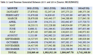
Total revenue generated and collected in the year 2011 was US$218,869.46. This contrasted sharply with the increase of a total collection of US$1,983,912.31 in the following year. The 2013 figures were even more impressive with an alltime high record of US$2,800,067.78.
The collection for the year 2014 almost doubled that of 2012 at US$3,741,308.85. The month of December 2014 was a significant month because of the record collection US$850,682.85. (This figure was more than the total revenue collected for the three years of 2007 – 2009, which stood at US$753, 791.57 only). See Table 3.
This dramatic increase has now lifted the revenue profile of the state and made the contribution of the Land Ministry to rise from only 1% to over 30, thereby making it the largest single contributor of IGR to the state.
The development of a robust spatial data infrastructure is one of the most significant determining factors that have led to this increase in revenue collection. The determination of the state administration to pursue the project vigorously is another factor that led to the upward revision of land fees and charges and the subsequent rise in the revenue profile. The automation of the system has proved to be robust, consistently producing all forms of land documents.
All new applications and transactions are managed by the systems, which makes it easy to retrieve files and process fast.
Billing and issuance of such bills became simpler and more vigorous. Similarly issuance of demand notices started and is now more regular unlike the past when no such notices were issued. Recent trend has shown that public has now realized the determination of the administration to issue title documents. This has also increased the awareness and willingness of property owners to pay land charges in order to obtain a more secure land title document. This is an important positive sign for the state.
This can be seen from the number of applicants that come forward on a daily basis to file new applications in the land records section (See Figure 31). The billing system that used to take a lot of time for the Land Revenue Officers to calculate and dispatch to land title holders for payment because it was done manually, has now been automated. The result is a dramatic reduction in the amount of time spent now to process title documents. A more efficient revenue collection is in place, further preventing any form of sharp shady practices that may have been in place old system. So far the initial results has have shown a promising future for the state government. Figure 33 shows the revenue profile as generated by NAGIS and collected by MLUD. From the figures one can see clearly that the generation of revenue is by far ahead of the actual collection. While more than N1, 400,000,000.00 (approximately US$8,750,000.00) was generated, only N608,689,414.32 (approximately US$3,741,308.85) was actually collected.
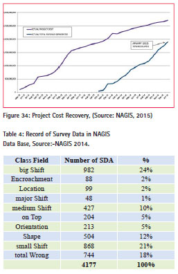
This leaves us with an outstanding figure of over US$5,027,813.67 yet to be collected. The above scenario has clearly shown that the project is well on its way to recover cost of the initial investment made by the state government. Figure 34 illustrates the actual project cost and what was recouped as in January 2015. This figure of 70% is extremely impressive as no state agency has ever performed such a feat.
Our realistic projection based on actual past performance is for a complete cost recovery of the initial investment made by the state government till July 2015.
Challenges
Data cleaning exercise & quality control
A significant achievement in this project is the improvement in the quality of data that is now available in the NAGIS data base. Prior to the commencement of this project it was common practice to obtain title documents over a parcel of land with an ordinary site plan.
The drawback of this old system is that the site plan does not give an accurate representation of the actual size and location of the property in question. This has led to many problems and disputes over boundaries and in a lot of cases outright wrong locations and in some cases series of litigations. It should be noted that the state has a long history of land administration and land management issues. Oldest survey data/ records (so far identified) and captured in the land archive, dates back to 1933 (82 years). See Figures 27 & 35.
With a structured GIS driven data base it became absolutely necessary to use accurate an survey order to arrive at exact locations. This has necessitated the use of modern high precision survey equipment with attendants’ accuracy that is of world standard. This no doubt has brought about so many challenges. So far more than 34,615 coordinates of Property Beacons (PBs) have been captured into the GIS. An analysis of the records of 4,177 sets of survey data carried out so far has revealed a variety of results. (See table 4)
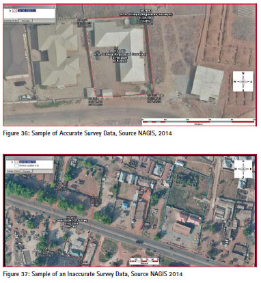
It is significant to note that only 5% of the analyzed 4,177 set of data are classified as accurate. Of this, 18% are totally wrong, while 12% have a changed shape, and 24% have a significant or big shift from their actual locations (See Figures 36 & 37). These issues are attributed to multiple reasons, among which are old survey equipment, unqualified and ill-equipped personnel carrying out survey activities, using wrong reference points, etc. It is common knowledge that there are errors in the geodetic network in Nigeria. Arinola (2006) observed errors in the Nigerian Geodetic Network (in some cases up to 9 m).
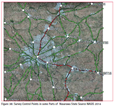
In recognition of this challenge the project has moved ahead to establish two Continues Reference Station (CORS) as well as 100 primary ground control stations across the state’s land mass in order to strengthen the geodetic network in the country. This would go a long way to compliment the efforts of the office of the Surveyor General of the Federation of Nigeria (OSGF) as well as assist both public and private survey and cadastral activities in the state (See Figure 38).
Some significant milestones & other challenges
Past practice of missing paper documents are now over with all the land data fed in a data base. The implication of this development is that unlike in the past when land files could be misplaced, lost (or even hidden by some unscrupulous staff members), now, any file that is misplaced, its electronic copy could be reproduced and processed without any problem for the applicant.
The computerized system is able to bring out the errors inherent in the old analog system. Though this has been a source of constant friction with the existing surveyors, field verifications are underway in order to get to the root of all the challenges and sort them out.
Training is also given a prominent place in the new system in order to ensure smooth transition from the old analog system to the new digital format.
Another source of friction is the resistance and the fear of the unknown for senior government staff. However training is given prominence in this project. This has assisted tremendously and has gone a long way in reducing the fear as well as restoring confidence of the staff.
Summary of lessons learnt and the benefits of the project to the state
NDP/ NAGIS project and subsequent development of Spatial Data Infrastructure benefits the state government and organizations of all sizes, and stimulates economic development by enabling citizens and private enterprises to register land and property, securing their investment in a transparent and safe system. Good governance is enhanced and achieving sustainable development is now a realistic goal.
Cost savings resulting from greater efficiency
These are associated either with carrying out the mission (e.g. labour savings from automating and optimising workflows) or improvements in the mission itself (secure documents such as receipts and Certificates of Occupancy underpinned by electronic systems). For example, GIS is reducing the time taken to register land in Nasarawa state.
Significantly increased revenue generation
People are encouraged by the efficient system and the secure documentation to register their land. More people have obtained Certificates of Occupancy (C-of-O) since the inauguration of NAGIS than previously. This has resulted in significant increases in the revenues generated.
It is important to note that these revenues are sustainable, as conveying more C-of-O’s will result in increased Ground Rent collections. As more people obtain C-of-O’s investment in the development of new property surges, resulting in development control charges and increased property tax and tenement rates.
District Planning and improved decision making
District Planning typically has to do with making better decisions about location and zoning, with typical examples such as housing (real estate site selection),transportation (route/corridor selection), industrial and commercial centres, agriculture and conservation, natural resource extraction, etc. There is recognition that making the correct decision about a location is strategic to the success of government initiatives and strengthens sustainable development.
NAGIS is undertaking extensive field surveys in key urban areas to provide data that can aid city and district planning, bringing together field data and 10 cm orthophotos in a variety of maps that can support the provision of other vital services such as storm water management and security.
Improved communication
GIS-based maps and visualizations greatly assist in understanding situations and in storytelling. They are a new language that improves communication between different teams, departments, disciplines, professional fields, organisations, and the public.
Senior administrators and executives at the highest levels of government use GIS to communicate, using a visual framework for conceptualising, understanding, and prescribing action. Examples include briefings about land use, crime, homeland security and defence, the environment, and economic opportunities.
Better geographic information recordkeeping and management
Despite the fact that Nigeria is an oil rich nation approximately 70% of the people live in poverty, presenting a challenge to the efficient management of civil administration. Added to this, many people migrated to Karu and Keffiareas of Nasarawa and created dwellings due to the proximity with Abuja and the lure of jobs, adding additional planning and socio-economic challenges.
Government ministries have a primary and statutory responsibility to maintain authoritative records about the status and change of assets and natural resources, including examples such as land use (zoning), land ownership (cadastral), administrative boundaries, infrastructure (including roads, hospitals and schools), forest inventories, agriculture inventories, environmental measurements and water flows, and a whole host of geographic accounting.
Assets and resources can be maintained using an expanded GIS enterprise information system to support day-today work, management tasks, and to provide a broader context for assets and resource management. GIS provides a strong framework for managing these types of systems with full transaction support and reporting tools. These systems are conceptually similar to other information systems in which they deal with data management and transactions, as well as standardized reporting of changing information. However, they are fundamentally different in the use of maps containing specified data.
Conclusion
The state government has so far paid the consultants more than 90% of the total sum. The revenue generated so far has gone up to 70% of the total sum so far invested since the beginning of the project. A full recovery is expected within the middle of this year. No project in the state has shown greater potential of revenue generation than the NDP project. It is so far a pace setter and when fully consolidated in the second stage other arms of the state government would be expected to key in and use the GIS tool for effective service delivery. This project has shown that well-focused planning, proper funding and careful supervision can deliver a modern spatial data infrastructure to immensely benefit the people and government. This is the most important lesson that could be learned from the Nasarawa State experience. It is our hope that other states in Nigeria would follow this good example in order to better serve humanity.
References
Envicons Team Consultants Limited (2013), General Land Use, Detailed District Plans and Urban Renewal Scheme for Karu/ Keffi, Inception Report, NSSG.
Envicoms Team Consultants (2013), General Land Use, Detailed District Plans and Urban Renewal Scheme for Greater Lafia, Inception Report, NSSG.
SIRAJ Consulting (2012), Client/ Consultant Service Agreement, NSSG.
UN-Habitat (2012), Master Plan for Karu and Environs (2012–2031), NSSG. UNHabitat (2012), Master Plan for Keffiand Environs (2012–2031), NSSG. UNHabitat (2012), Master Plan for Lafia and Environs (2012–2031), NSSG.
The paper was presented World Bank Conference on Land And Poverty The World Bank – Washington DC, March 23-27, 2015


 (2 votes, average: 3.00 out of 5)


Thank you for this very detailed and rich review, your highness. Unfortunately, there is no such detailed information to the citizens especially through our traditional communication channels of radio and television. This really this publicity so that the public can effectively engage succeeding administrations to sustain the laudable project to full completion.
This is indeed a landmark achievement and kudos to you all.
Leave your response!