Articles in the Surveying Category


Unmanned aerial vehicle (UAV) is emerging to become a common tool in the geoscience field as it is usable across different field to cover a large-scale area with minimal cost…

Traditionally the surveying profession contributed to the good of society by creating and maintaining highly precise and accurate geospatial data bases, based on an in-depth knowledge of spatial reference frameworks. Furthermore in many countries…

Finland is a European hub for mineral exploration and mine development. Nickel, zinc, copper, chrome and gold form Finland’s most significant metal mineral resources. Metal, industrial mineral, and rock mines can be…

This study explores the existing CORS network particularly the Greater Accra CORS to know the extent of its usage for GPS surveys in Ghana and to determine its usefulness in ensuring uniform and homogenous data collection
Surv. Sebastian Botsyo (MGhIS)
Ghana School of Surveying and Mapping, Cantonments, Accra, Ghana
Bernard BORKETEY BORTEI
Geomatic Engineer, Volta River Authority, Ghana
John AYER
Senior …

A digital ledger is a geographically distributed database that is shared and synchronized across a network by consensus of the network participants…

The world is going digital. Advancements in technology and an evolving society are coupling to mean it is fast becoming the norm to provide and consume information digitally. Local and central governments are reacting…
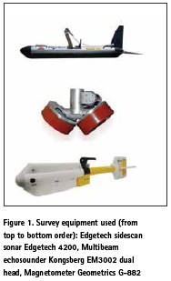
The purpose of this paper is to conduct the evaluation of the object detection using sonar and geophysical methods. Increasing interest in maritime archaeology has led to a growing need for measuring techniques or innovative methods..

Paddy is the third largest crop planted in Malaysia after oil palm and rubber. According to Paddy Statistics of Malaysia 2014 reported by Malaysian Department of Agriculture, nearly 679 239 hectares of land planted with paddy in Malaysia.

This paper discusses ethics in the field of social responsibility, the relationship of professional ethics to professional malpractice, the new IESC code and its relationship to the existing FIG Statement of Ethical Principles and Model Code of Professional Conduct, and the issue of enforcement
Robert W Foster
Past president of the American Congress on Surveying and Mapping, …

The paper presents the results of research of various classification models for vertical displacements and their further prediction. When performing geodetic monitoring of complex engineering structures under reconstruction, the displacements of the structure is always unequally…


 (5.00 out of 5)