| Surveying | |
Fit for Purpose Parcel Mapping Methodologies for a Seamless Cadastre Database
Parcel mapping that ensures secure land tenure for a large percentage of a nation’s citizens can be produced at an acceptable and Fit-for-purpose level of accuracy using general boundary survey techniques that are a small fraction of the cost of parcel mapping created using fixed boundary survey techniques. Readers may recall that the first part of the article was published in the last issue. We present here the concluding part of the paper |
 |
|
The Seamless Cadastre Database
There are several compelling reasons for surveying a property parcel that will become part of a comprehensive fiscal cadastre:
• Problems with inadequate cadastres, lax and inequitable tax policies and practices hinder the revitalization and maintenance of neighborhoods and prevent local governments from collecting revenue needed to support public services.
• Provide documentation in the form of a parcel survey to help citizens achieve secure land tenure
• A property owner desires to know as accurately as possible the value of his or her asset when selling a property or seeking a mortgage on it, and;
• A taxing agency needs to know the area of a parcel in order to apply the correct property tax rate to it
Parcel corners locate parcels on the surface of the earth, to one level of accuracy or another, resulting in a coordinate-based cadastral mapping system that is improved and updated as new parcels are surveyed or mapped over time. An important role that is played by parcel corners is the ability to calculate the area of a parcel based on the parcel corner coordinates. Therefore, the more accurate the parcel corner coordinates, the more accurate is the resulting parcel area calculation. Regardless of the methodology employed for the location of parcel corners on the earth’s surface, it is impossible to calculate any parcel area with 100% precision.
There are two primary technologies employed today in the task of locating parcels on the earth’s surface.
1) Land surveying: Land surveyors use a total station (a tripod mounted optical instrument that measures angles and distances between parcel corners along a parcel boundary) and GPS receivers that locate a position on the ground based on time and distance measurements to satellites that are in orbit above the earth. When parcel corners are surveyed using either total station or GPS technology, the resulting fixed boundary accuracy of parcel corners can be calculated to within a few centimeters of their true position. A two man field survey crew can survey fixed boundary parcels at the rate of 3 to 10 a day, depending on the complexity of the parcel boundaries.
2) Aerial surveying: Aerial surveying, or photogrammetry, is widely employed throughout the world to create general map boundary databases over very large portions of the earth’s surface. When parcel corners are surveyed using photogrammetric technology, their resulting accuracy can be calculated to within 5 centimeters to three meters, depending on the level of accuracy of the underlying photogrammetric map that has been created. Individual mapping technicians (using inexpensive office-based workstations) can survey general boundary parcels at the rate of 40 to 50 per day, depending on the complexity of the parcel boundaries.
The major differences between land and photogrammetrically surveyed parcel corners are the accuracy, cost and time required to create the parcel corner coordinates. (McKenna, 2016)
Deferred Monumentation – Good Idea or Bad Idea?
In his excellent, informative and mostly pragmatic paper, “Deferred Monumentation and the Shakedown Factor”, D. Goodwin discusses how surveyors and legislators, in their efforts to define land unambiguously, have had to consider a number of models including the general boundary system, even though the physical boundary features such as fences and walls sometimes disturb or destroy boundary marks when they are erected. Additionally, they usually are not erected exactly on the legal boundaries, either to avoid disturbing boundary marks or else in ignorance of their position. In another widespread model, the fixed boundary system, corner boundary marks are the norm. Goodwin raises two questions. First, whether it would be better for surveyors to place boundary marks after the erection of physical boundaries, roads and services, and second, whether it is necessary to place boundary marks at all, or whether these should be placed only to resolve conflict where this arises.
Goodwin discusses his Case Study 1: High Density Developed Townships in Zimbabwe. HDDTs, which make up a significant percentage of dwellings in Zimbabwean urban centres, typically cater to lower income residents. The townships were originally set out by the Department of Physical Planning to nontitle specifications, and core houses were built, amounting to approximately half of the final residential unit. Non-title pegs that were placed were necessary for the orderly building of roads and houses, and guiding the erection of physical boundaries. Despite having no legal weight, these pegs also assisted from time to time in arbitrating disputes.
The following are thought to be the most significant questions asked of residents in Goodwin’s research:
Question: How long does it take right holders to enclose their properties with some form of physical boundary?
• About 20% of physical boundaries are built in the first year of occupation
• Approximately 50% of the properties are enclosed by about four years
• Approximately 66% of the properties are enclosed after about seven years
• After 17 years, 90% of properties are enclosed by physical occupation lines.
Question: What form is the physical boundary?
• Fence 63%
• Hedge 16%
• Concrete wall 9%
• Brick wall 3%
• Other 3%
• No physical boundary 6%
Question: What is the reason for erecting a physical boundary?
• 50% Increased security
• 25% To keep animals from eating their vegetables
• 10% To remind neighbours of where the boundary was (i.e. it was some kind of territorial statement)
• 5% For aesthetic reasons.
Question: Is there any dissention with neighbours over the common boundaries?
• Ninety-eight per cent of respondents had achieved amicable consensus over the common boundaries, even where these departed from the pegs originally placed.
According to Goodwin, the gains accruing from deferring boundary monumentation are seldom justifiable, and boundary marks should have well defined centre-marks and be surveyed to accuracies comparable with survey control marks in order to densify control and to act as witness marks. The research summarised by Goodwin suggests that, although right-holders generally regard physical boundaries as the primary boundary evidence, departures with legal boundaries are seldom a threat to secure title. Finally, wherever there is doubt, dispute or disaster, it is important that a dense network of surveyed points exists, whether control marks or boundary marks, that can be used in arbitration and reinstatement. All compromise is based on give and take, but there can be no give and take on fundamentals. Goodwin draws the conclusion that any compromise on mere fundamentals is a surrender. He states that physical boundaries erected by abutting right holders exhibit a degree of give-andtake, and right-holders tend to regard these positionally-flawed physical boundaries as the primary source of boundary evidence, but the underlying fundamentals of welldefined marks, both control marks and well defined boundary marks, should not lightly be surrendered. (Goodwin, 2013)
Author note: In a world where time and money are not a consideration, Goodwin’s conclusions are beyond reproach. Like Goodwin, the author of this paper has densified control networks through the use of accurately surveyed permanent parcel boundary marks (all photo identifiable for use within aerial triangulation block adjustments) for inclusion in the national network. However, the cost to install parcel corner boundary markers that will then be surveyed in the field is simply prohibitive to most national and local governments in developing countries. The urban area around, for example, Nairobi, contains approximately 1.5 million parcels. How long would it take and how much would it cost to install and survey boundary marks to each of those parcels? Maybe $50, more likely $100 per parcel, and very likely more than that. This is too much time and money for government agencies who urgently desire to have a functioning and affordable revenue-generating fiscal cadastre as soon as possible. Digital orthophotography will provide the means to create as many as 75% of those parcels at a fraction of the cost ($10 approximately) required for general boundary parcels compared to the cost of fixed boundary parcels. Well-defined boundary marks can be installed and surveyed for those parcels that cannot be mapped using general boundary mapping techniques. Likewise, any general boundary surveyed parcels whose ownership is transferred can have well defined boundary marks installed and surveyed (at the seller’s expense) with a subsequent upgrade of its status within the cadastre to a fixed boundary parcel. The unfortunate reality is that monumentation of all parcel corners will result in deferred revenue collection.
Goodwin did not mention the shortcomings of the physical flaws involved with the recovering of fixed boundary markers: namely the “Pincushion Effect”. The “pincushion corner” is a term coined by surveyor and author Jeff Lucas to describe the phenomena of multiple boundary markers being set by land surveyors when only one boundary corner exists under the law. It is common knowledge that no two surveyors can agree on the location of any given property corner. The pincushion is physical proof of that notion. Is the pincushion also physical proof that the entire 2cm accuracy fixed boundary claim is a tad over rated?
Area Calculation Comparisons of a Fixed Boundary and a General Boundary Surveyed Parcel
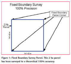
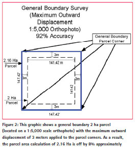
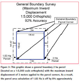
The diagrams (Figures 1, 2 and 3) show how the area of a hypothetical 2 Ha parcel is calculated using fixed boundary survey coordinates values (theoretical 100% precision) and using general boundary coordinate values (a 3 meter off-set to reflect the maximum error obtained from a 1:5,000 digital orthophoto). The maximum coordinate off-set (outward or inward) results in an area calculation for the parcel that is within 8% of the actual parcel area. It should be noted that a coordinate error of 3 meters is associated with mapping accuracy that is inferior to Class 2 accuracy as defined in the ASPRS Map Accuracy Table shown in Table 1. Class 2 accuracy should be the minimum accuracy level applied to cadastre creation.
What is a Cadastre?
A Cadastre is a public record that contains a delineation of individual parcel boundaries, attributes for ownership information and the rights associated with each parcel that is used to confirm ownership and as a basis of property taxation. When all ownership information is accumulated a modern land administration system is developed which is used to feed a GIS (in addition to a variety of land records management software such as modules for land registry, cadastre and valuation records keeping), maintain cadastral mapping databases and enable property tax revenue calculation.
Most countries that use modern GIS, total station, GPS and photogrammetric mapping techniques to create a contiguous parcel database (cadastre) for the calculation of property taxes primarily use the general boundary survey methodology to create a database of calculated parcel areas based on general boundary parcel corner coordinates. Because of the reality that the resulting calculated areas are in error from 3% to 8% for ASPRS Class I or Class 2 mapping at a scale of 1:5,000 (Class 3 mapping is rarely used due to the higher errors achieved) the billing area for each parcel could be reduced by 10%. That is, if the parcel area calculated from a general boundary survey is, for example, 2.39 Ha, then the area billed by the tax office could be 2.39 Ha less 0.24 Ha, or 2.15 Ha. This 10% buffer ensures that owners have confidence that they are not being over-billed for the taxes associated with their property. In the event that the owner needs to determine his property area with greater accuracy, for example when applying for a mortgage or selling the property, then a 2cm accuracy fixed boundary survey can be carried out at the owner’s expense.
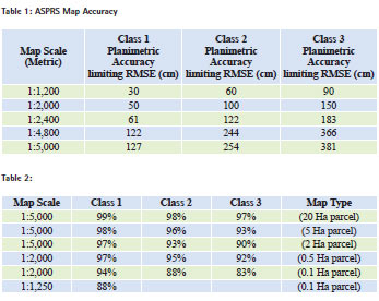
The Table 1 shows the level of accuracy that is achieved utilizing photogrammetric mapping techniques that are based on internationally accepted mapping standards. American Society for Photogrammetry and Remote Sensing (ASPRS) mapping accuracy is reported as Class 1, Class 2, or Class 3. Class 1 accuracy for horizontal and vertical components is shown below. Class 2 accuracy applies to maps compiled within limiting RMSE’s twice those allowed for Class 1 maps. Similarly, Class 3 accuracy applies to Federal Geographic maps compiled within limiting RMSE’s three times those allowed for Class 1 maps.
ASPRS Accuracy Standards for Large- Scale Maps evaluates positional accuracy for the x-component and the y-component individually. Positional accuracy is reported at ground scale.
The table 2 shows the accuracy obtained for general boundary parcel calculation for parcels of varying areas, depending on which accuracy class and map scale has been used for the digital orthophoto production.
Note: Parcel calculation accuracy increases when the map scale is smaller and the parcel area is larger.
Note: Whatever the level of accuracy that is achieved using general boundary survey methodology, it is important to note that the cost of creating a general boundary parcel is typically 5% to 10% of the cost of creating a parcel using fixed boundary survey methodology. Parcels measuring 0.1 Ha or less could be placed in a uniform category for taxation purposes.
Large Administrative Area
Parcel Databases When parcel corner coordinates are acquired for a large number of parcels, for example for a village, a city or an entire country, a cadastral geodatabase is created. A cadastral database represents and contains ownership data for a continuous surface of connected parcels.
If a parcel split occurs, two new parcels are added to the cadastral database and the original parcel database is maintained as part of the historical record. In a geodatabase, the parcel-based topology of the database determines how parcels, boundary lines, corner points and other features share coincident geometry. Parcel polygons are defined by a series of boundary lines which can store recorded dimensions as attributes in a lines data table. Specific topological conditions support multiple survey records for adjacent parcel boundaries whose dimensions are specific for each parcel, even when the boundaries are shared. Topology is a branch of geometrical mathematics which is concerned with order, contiguity and relative position, rather than actual linear dimensions.
Parcel polygons can be connected to each other by connection lines, for example those parcels that cross roads. Because each parcel is either linked or connected, a seamless network of connected parcel boundaries (i.e., the contiguous cadastral database) is formed. Parcel corners are the endpoints of parcel lines and they are common between adjacent parcel boundaries. This establishes connectivity and maintains topological integrity within the contiguous parcel database.
For a parcel survey that is being submitted in support of an application for a mortgage loan, marked parcel corners can be very accurately located using total station or GPS surveying equipment. The resulting survey of parcel corners in this manner is known as a “Fixed Boundary” survey. Often, even though the parcel is surveyed with great precision, the parcel corner coordinates are not produced on the national grid, but are created with parcel corner coordinates that are on a local grid specific to that parcel only. This is a major drawback when the parcel information is required to become part of a national cadastre.
The parcel corner coordinates are not intended to provide the true legal representation of a cadastral parcel. They are merely a part of the methodology developed to represent all the historical and legal record information available within a land administration system. Some GIS software packages (such as Esri’s Parcel Fabric) support a coordinate-based cadastre with the goal to continually refine and establish digital representation of coordinates at the corners of parcels.
Surveyors have traditionally recorded parcel boundaries through the use of bearings and distance dimensions. For many years cadastral boundary networks were created with no accurate reference to real-world coordinate locations as surveyors did not tie into the national grid. With the advent of high accuracy total station and GPS surveying equipment it has become significantly easier to use coordinates to geographically define parcel locations. Traditional survey methods used for relocating property boundary corners may be interpreted in different ways. When different surveyors use different positioning data to re-establish the location of a boundary, boundary location disputes often arise. A coordinate provides a unique and unambiguous record of a point and can be quickly and accurately relocated with the use of total stations and GPS receivers.
To gain maximum benefit from the use of coordinates, a system needs to be in place within the cadastre that provides a measure of the reliability, consistency and accuracy of coordinates in a parcel boundary network. Traditional parcel data management has focused on entry of individual parcel and subdivision plans that use coordinate geometry (COGO) to enter high accuracy metes (bearings and distances) and bounds (neighboring lands) descriptions. The following is a typical metes and bounds example: “Commencing at the point of beginning then North 44°35’16” East 100.26 meters, then Northwest 26° 14’58” 195.37 meters”. Using such a workflow, individual parcels or subdivision plans are entered independently of all other survey plans. While such a workflow is adequate for management of individual parcels, a contiguous parcel database across an entire jurisdiction is difficult to assemble in this manner.
Efficient management of a government cadastre demands the utilization of a contiguous parcel database. New and cost effective photogrammetric mapping technology has resulted in the availability of affordable high resolution and geospatially accurate digital orthophotography. The digital orthophoto imagery (from satellite or airborne sensors) provides a very affordable option for the creation of a contiguous cadastral database. The technique used to locate cadastral parcels onto a digital orthophoto back drop is known as “Best-fit to Ortho Parcel Mapping”.
The best-fit-to-ortho mapping technique involves use of geo-referenced images of digital orthophotos that have been created for a given jurisdiction (for example a municipality). Using this mapping technique, cadastral maps are completed to the same level of accuracy as the digital orthophotos based on the visual fit of the parcel boundaries to photo identifiable features that appear in the digital orthophoto image.
The following steps are taken in the cadastral mapping workflow:
• Analyze the location of roads, tracks and trails that appear on the digital orthophotos and use those features as guidelines for the placement of road Rights-of-Way (ROW) and road centerlines.
• Analyze ground evidence on the digital orthophotos pertaining to structures, fences, walls, hedges, hydrographic features, vegetation lines and agricultural lines and use these features as guidelines for the placement of parcels.
• Place the pertinent data for parcels on a block-by-block or small-cluster basis.
• Create a unique parcel identification number (PIN) for each parcel.
• Place Errata Notes for areas of conflict that will require adjudication.
It is important to take note of the fact that when fixed boundary parcel surveying techniques are used to create individual survey plans with survey precision, that precision is lost when the parcels are recreated as a contiguous parcel database using topographic maps or digital orthophotos as a backdrop. The resulting contiguous parcel cadastre acquires map accuracy and results in the creation of a “General Boundary” survey based cadastral database. (McKenna, 2016)
Conclusion
Parcel mapping that ensures secure land tenure for a large percentage of a nation’s citizens can be produced at an acceptable and Fit-for-purpose level of accuracy using general boundary survey techniques that are a small fraction of the cost of parcel mapping created using fixed boundary survey techniques. Most modern cadastres, including most of the 3,000 American county cadastres, are mapped according to internationally recognized mapping standards for map scales of 1:1,250 (urban), 1:2,500 (peri-urban), 1:5,000 (rural) and 1:10,000 (rural).
Note US map scales are typically 1:1,200 (urban), 1:2,400 (periurban) and 1:4,800 (rural).
As a result of the reality that there is a choice of utilization of two different survey techniques (fixed boundary and general boundary) for the creation of cadastral maps, it is essential for users of a cadastre to be aware of the fact that parcel corner coordinates can be provided in two options:
1) Fixed Boundary Parcel Corner Coordinates
2) General Boundary Parcel Corner Coordinates
A map accurate contiguous general boundary cadastral database is cheaper, faster to produce and considerably more efficient to manage topologically than an individual parcel, fixed boundary, based cadastral database. As stated above, it is important to note that individual parcels created using fixed boundary survey techniques eventually need to be reassembled into a contiguous parcel database that inevitably involves use of a digital orthophoto or topographic map database that relegates them to general boundary status.
Cadastral databases must have a continuous parcel network that can be managed and referenced to real-world coordinates using a comprehensive geospatial framework. The feature geometry of many GIS data layers is required to fit onto, and be coincident with, the cadastral database. The result is a highly accurate GIS database that meets the goals of surveyors, registry and cadastre offices, tax offices, multiple government agencies and GIS professionals and supports multiple GIS applications that must have geospatially accurate data layer representations.
It has been demonstrated above that a general boundary parcel corner accuracy of 3 m (1:5,000) or better (easily attainable using even satellite imagery) is capable of parcel area calculation that is within 92% of the parcel’s actual area. Using the latest available technology, digital orthophotos can be created that enable general boundary parcel mapping that is accurate to 30 cm. Such accuracy produces digital orthophotos to 1:1,250 map accuracy standards, an accuracy that has been, and still is, internationally regarded as a very acceptable accuracy for topographic and parcel mapping.
Many so called “fixed boundary” parcels are surveyed by less than competent surveyors (for sure the pincushion practitioners!) using inferior optical equipment for angle measurement and less than adequate distance measurement techniques (e.g. un-calibrated measuring tapes) that are fortunate to achieve survey traverse closures of 1:5,000. Using modern optical survey equipment there is no reason why 1:25,000 should not be the minimum standard for a traverse closure for a parcel survey.
Note: The traverse closures quoted above are not to be confused with mapping scales.
Cost effective photogrammetric mapping technology and the use of Best-Fit- To-Ortho mapping techniques enables creation of affordable and accurate general boundary mapping. Digital orthophoto imagery (from satellite or airborne sensors) provides a very affordable option for the creation of a Fit-forpurpose contiguous cadastral database.
Even the poorest of countries sometimes insist on creation of a fixed boundary cadastre, while overlooking the absence of an exact definition of a fixed boundary survey. Instead the demand is often made for all parcels to be surveyed to an accuracy of 1 or 2 cm.
When does a fixed boundary survey become a “real” fixed boundary survey? Is it when parcel corners are surveyed to 1 cm accuracy? Or 2 cm accuracy? Or 10 cm accuracy? There are those who are of the opinion that even at 1 cm parcel corner accuracy, the parcel is still a general boundary survey. Perhaps the only “true” fixed boundary survey is one that is surveyed with 0 cm accuracy. And that will never happen: even minor tectonic shifts will ensure that is the case. If a homeowner or bank must have a 1 cm accurate survey plan then that homeowner, not the other citizens, can pay to have that survey completed at a cost, depending on the country, between $200 and $1,500. Compared to the approximate $10 per parcel cost for general boundary parcel mapping. And besides, the fixed boundary parcel is no more efficient at being the repository for all parcel attributes (rights, owner name, valuation, etc.) than a general boundary parcel. The reality is that a general boundary parcel is a really good location for “parking” the scanned image of a fixed boundary survey plan of the same parcel. It is a simple matter to attach that scanned fixed boundary survey plan as an attribute to a general boundary centroid, click on the centroid and display and print the survey plan.
General boundary surveys can result in cost and time savings of as much as 90%. The question must be asked: “Is the relatively exorbitant cost and huge increase in time required to create a fixed boundary cadastre a technologically, financially and politically prudent direction to take?” This paper demonstrates that general boundary parcels are created with Fit-forpurpose accuracy, quicker and cheaper per the FIG and World Bank Fit-forpurpose objectives. Realistically, the cost for cadastre creation should be a hybrid of both surveying methodologies: general boundary parcels using photogrammetric data (topographic mapping or digital orthophotography) and fixed boundary for the parcels that cannot be derived by any means other than field surveying. It is time to stop thinking of parcel corner accuracy in terms of centimeter accuracy for creation of most fiscal cadastres. It is time to create affordable revenue-generating cadastre databases, based on the UK Land Registry model, which comply with the accuracies of time-honoured map scales of 1:1,250, 1:2,500, 1:5,000 and 1:10,000 and put the cost savings to good use on other aspects of land administration activity.
References
Benjamin, Lennard Cherry; Marigold, Harold Walter, (1899) The Land Transfer Acts of England and Wales, 1875 and 1897, Rules and Orders Thereunder, Published by Sweet and Maxwell Limited, London
Cahill, Kevin. (2006) Who Owns the World, Published by Mainstream Publishing Company, Edinburgh, Scotland
de Soto, Hernando, (2000) The Mystery of Capital, Published by Basic Books, New York, NY, USA
Goodwin, D (2013) Deferred Monumentation and the Shakedown Factor, Survey Review, 45:328, 19-24
Lucas, Jeffery N, (2011) The Pincushion Effect, The Multiple Monument Dilemma in American Land Surveying, Published by nsps, Book Review Quoted
McKenna, Jack, (2006) Making a Living in the Global GIS Marketplace, http:// www10.mcadcafe.com/nbc/articles/ view_article.php?articleid=246353
McKenna, Jack, (2016) Converting Dirt to Gold: How to Create Capital for Millions of People in Africa (Paper in Progress)
Victoria State Government, What is the Torrens Title System?
http://www.dtpli.vic.gov.au/propertyand- land-titles/land-titles/torrens-titles
what3words.com, what3words is a unique combination of just 3 words that identifies a 3mx3m square, anywhere on the planet
The paper was presented at FIG Working Week 2016, Christchurch, New Zealand, May 2-6, 2016


 (No Ratings Yet)


Leave your response!