Articles in the Articles Category


The Ashtech-branded GNSS boards and Integrator-ready GNSS receivers are now managed as part of the Trimble Integrated Technologies (OEM) business. That business sells not only GNSS technology but also digital radio technology and other integrator offerings including software and services. The Ashtech GNSS OEM portfolio nicely complements the existing Trimble “BD” range of GNSS boards, providing integrators with a wide range of options and capabilities to choose from.

In this first application of morphometrics to earthquakes, plot sequences are first provided for coordinate shifts, rotations, and uniform scaling on each separate day. In addition to those seven time histories from Procrustes representations,
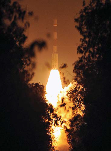
Finally, it happened on July 2, 2013.
India successfully launched IRNSS-1A
The fi rst satellite of Indian Regional Navigation Satellite System (IRNSS),
July 2013
International Geoscience and Remote Sensing Symposium (IGARSS 2013)
22-26 July
Melbourne, Australia
www.igarss2013.org
August 2013
International Summer Seminar on GNSS
19-24 August 2013
Tokyo , Japan.
http://www.gnss-pnt.org/summer_seminar/index.php
8th International Symposium on Digital Earth 2013 (ISDE 2013)
26-29 August
Kuching, Sarawak, Malaysia
http://isde2013.utm.my/
September 2013
Multi-GNSS environment for sustainable development
9 – 13 September 2013
Hoi An, Vietnam
http://navis.hust.edu.vn
Geo-Empower Middle East Summit
16-18 September
Dubai, UAE
www.fleminggulf.com/All-Categories
ION GNSS 2013
16 – 20 September
Nashville, Tennessee, USA
www.ion.org
GDI APAC …

Burgeoning energy needs in the 21st century are driving demands for more petroleum products. These needs were hitherto met by using pipes to transport required energy products over long distances within countries and across borders, from their sources to respective destinations (Chai et al, 2006; Yildirim et al, 2007; Dubey, 2009). However, increase in global…

Cities in developing countries are expanding rapidly and consuming every possible space available. The growth is not only in their physical expansion but also the increased urban population. The space consumption is again not only…

There have been many technological advances in cadastre, particularly with the workflows of how parcel data is managed and published. It’s obvious that data collection via satellite imagery, total station, and GPS have all advanced, but lesser seen is the management of this data, particularly maintaining all aspects of parcel data…

The automation of agriculture has become a significant concern due to the benefits of increased productivity and enhanced operational safety developed in 1997 [1]. In recent years, with the on-going development of mechatronic techniques, traditional manual work has been replaced by automated tools, such as the harvester, mower, and sprayer [2]. However, more specialized farming work still requires human manipulation of farming machinery….

senseFly drones were developed to off er end users a comprehensive mapping system that is both easy to use and portable without the need to be an experienced pilot. With our systems being the lightest in the industry at less than 700 grams and compact enough to fit into a single hand luggage case transportation is not a problem even to remote launch sites.

Nurture Nature
Climate change baffl es us all with
Undesirable consequences
As extreme heat and cold in many parts of the world
Floods in Europe, Flash fl ood in India
Unexpected summer and winter.
The mankind with fl aunting intelligence and knowledge
And powerful technological tools
May be able to understand and explain such phenomena
But may not be able to address them
Unless changes …


 (5.00 out of 5)