Articles in the Articles Category


Drones are defined as flying robots in simple terms which are formally known as Unmanned Aerial Vehicles (UAV). The main distinctive characteristic of drones is the design to be operated with no onboard pilot. They are operated by remote controller or can fly autonomously through software controlled flight plans….

Creating of national reference frame is not an easy task because Earth’s crust continuously undergoes various deformations. Repeated geodetic determinations of the positional relationships and elevations of points on the earth’s surface at certain time intervals make it possible…


This training was organized in the African Regional Centre for Space Science and Technology – in French Language (CRASTE-LF) in February 2015 and January 2017 and in school Mines-Télécom in 2011, 2012, 2014, 2015, 2016 and next in February 2017…
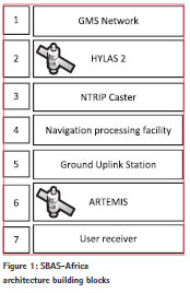
Whilst Europe has benefitted for a number of years from the European Geostationary Navigation Overlay Service (EGNOS) and North America from the Wide Area Augmentation Service…

On 15 December last year, during a ceremony which was attended by all the main actors of the Galileo program at institutional level (Commissioner Bienkovska and Commissioner…

The city of Christchurch, New Zealand, has suffered over 10,000 earthquakes since the M7.1 earthquake which occurred on 4th September 2010…


 (5.00 out of 5)