| Mapping | |
Cadastre and Land Register Maintenance in Finland
The LIS is complex combination of systems consisting of a number of subsystems, which all have to work together |
 |
|
In Finland, the Land Information System (the LIS) has for a while already been in a digital format. In recent years, we have developed new maintenance tools that save manpower. We have also developed operational environments to respond to today’s needs. Nowadays there is continuous demand to make all activities more efficient.
Maintenance of LIS needs several software and auxiliary systems to work well. The LIS is complex combination of systems consisting of a number of subsystems, which all have to work together.
Well working tools and databases is not enough to ensure that LIS maintenance is efficient. Updating the processes and structures of organisations, to take advantage of the possibilities that the online world has to offer is also necessary. The opportunity to work anywhere and at any time makes it easier to combine working time and leisure time, which in turn contributes to wellbeing at work.
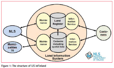
The structure of LIS in Finland
LIS consists of the Cadastre and Land Register and they both have applications to maintain data and give information services (Figure 1). National Land Survey (NLS) and 75 municipalities keep the Cadastre. Municipalities are responsible for recording data on real estates in their town plan areas. These areas are approximately 2% of the area of Finland area and 18% of the total number of real estates. NLS keeps the Cadastre in the rest of the Finnish territory. The Cadastre is nationwide, coherent and contains attribute and spatial data of real estates (Tuomaala, J., Uimonen, M.: Introducing the New Object-Oriented Cadastral Information System (JAKO) of Finland) and have been in today’s technical form since 2005 (Tella, A.: The New Land Information System in Finland). NLS has kept the Land Register since 2010. The new Land Register was introduced in 2013 and it contains data on the ownership of real estates (titles) and mortgages and encumbrances that burden the real estates. Both the Cadastre and Land Register are updated around Finland in 35 locations at the NLS’s offices.
NLS and municipalities update the Cadastre with changes which come from cadastral surveys using a maintenance application. The biggest municipalities also have real estate information in their own systems. First they update their own systems and from there transfer the changed real estate information using semiautomatic tools to the Cadastre.
After the real estate transaction is completed, the buyer has to apply for the registration of title to the property. Annotating the Land Register guarantees public credibility of ownership. The owner of the property can apply for a mortgage and use it to guarantee the loan. In the Land Register, the application for title or mortgages is processed by a maintenance application and the information is stored in the Land Register database.
The Land Register uses information from the Cadastre as basic information concerning the real estate, to which titles and mortgages are added. In addition, it is possible to make some annotations directly from legal cadastral surveys to the Land Register.
In the LIS there are three different kinds of information services. The web browser service is primarily used by authorities, banks and real estate agents. Via service interfaces (WFS and REST), several ICT companies have created their own services. From the service interface,it is possible to get via http-request different kind of certificates from the LIS in pdf format.
Third type of information services is data service by order (XML) by which is transferred changed real estate information to municipalities, to the tax authority and to the Population Register Centre.
The maintenance of the cadastre
The subsystems used in conjunction with maintenance of Cadastre
The whole maintenance system that is needed in the Cadastre update contains not only the Cadastre database and maintenance applications, but also several associated systems.
One import system is the electronic archive. Storing documents only in electronic format has been the only archiving form from the year 2009. We continually scan old documents, of which we have in total 15 shelf km and of which under 10 % is in digital format. The oldest maps are from the 1690s and the oldest other documents are from the 1750s.
Here are some examples of other associated databases and applications:
– actual transactions of real estates in purchase price register
– topographic and orthophoto data as background map
– legal surveys billing system – diary system of correspondence with clients
– statistic information of processes which update the Cadastre
Tools which make Cadastre updating more efficient
Cadastre maintenance is done by storing changes and additions from legal cadastral surveys and from decisions of the keeper of the Real Estate Register. See below some examples of the tools which make doing legal cadastral surveys easier and more efficient and, therefore, also the updating of the Cadastre.
Appointment of cadastral surveyors
NLS complete about 20,000 and municipalities about 4,000 legal cadastral surveys every year. To each new legal cadastral survey a cadastral surveyor must first be appointed. There is a tool in the cadastral maintenance application for selecting the cadastral surveyor. The tool shows where the legal cadastral survey is on the map interface and where the alternative cadastral surveyors are. It also shows the work situation of surveyors, e.g. the amount of incomplete work, which kind of legal surveys he can do and times when he is absent from the work. The surveyor can define his location as his home or, e.g. holiday cottage if he works from there in summer.
The institution of proceedings of legal cadastral surveys has been centralised and covers the whole of Finland. The initiator selects the cadastral surveyor who is best suited to handle the cadastral survey. This helps to minimise the driving and service times.
Initial data for legal cadastral survey
The cadastre is used as the source of initial data for the cadastral survey. Another source is the electronic archive. In Finland we cannot use the Cadastre as the only source of information.
Information from earlier legal cadastral surveys that concern that real estate unit must be checked. In the long run, the aim is that the Cadastre could be the only source of information for pending new legal cadastral surveys.
The locations of boundary markers are measured by GPS, from where they are transferred with their attribute data to the cadastre maintenance application.
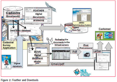
Electronic minutes – ‘Feather’ tool
The electronic minutes of a legal cadastral survey and the electronic notification of meeting make using a dedicated tool, Feather (Figure 2). The idea is that the tool can generate as complete minutes as possible.
Feather is used to fetch the basic information from that particular legal cadastral survey.
The information is located directly to the right place on the minutes. The tool contains a text bank from which text can be selected depending on the type of legal cadastral survey. The user can also select old minutes when starting to write new ones and use the tool to fetch the right information from the database to the minutes.
The electronic signature guarantees the constancy of the document and saves it only in electronic format to the archive system.
Previously, we scanned manual documents into electronic archive. Today, all documents go directly in electronic format to the archive. The change has saved about 5 person years every year.
Sending documents by post – ‘Dove’ tool
Every year, we send about 550,000 letters to our customers. The customers of legal cadastral surveys receive notifications, invitations, minutes, extracts and other documents from the NLS. We have developed a tool with which those documents can be prepared, sent and archived. The tool is called ‘Dove’ (Figure 2).
All documents to the client are sending using the Finnish postal service provider Posti’s iPost-service. Documents are sent in pdf format, and printed out as iPost documents and put into envelopes by the iPost service, to be delivered to clients. The tool has saved about 10 person years of manual labour each year.
The documents from legal cadastral surveys can also be delivered to clients bye-mail. Especially major customers, such as electricity and forest companies, use this service.
In the summer 2015 we will take into use the citizen’s account where the client’s official documents will be delivered, instead of delivery by post or e-mail, provided that the recipient has opened a citizen’s account. When we send the documents, the application check if the client has account and if there is one, the documents are sent there.
The citizen’s account is communication form which makes an electronic connection between citizen and authority possible. Using the citizen’s account person can receive announcements from the authorities, decisions and other documents in digital format, in a safe manner and in one place. Accounts can also be used in bidirectional communication.
The last stage of a legal cadastral survey is sending the invoice to client. It is also sent automatically from the billing system. All information is also recorded automatically in the diary system.
The future of the Cadastre
In 2017, the possibility to form 3D real estate units will be added to the Cadastre in Finland. However, the technical solution is in 2D. 3D real estate units can be located above or below ground. 3D real estate units are projected areas to the Earth’s surface, whose highest and lowest height is known. The detailed spatial extent is clarified in documents.
Currently we are investigating what kinds of e-services the public needs. We talk about bidirectional services, which help customers to do business online and at the same time help us do legal cadastral surveys.
The long-term aims of the cadastre are being considered. One thing that is being investigated is the possibility to use the cadastre as the only information source, as a coordinate cadastre, without the archive. When developing any system, it is also necessary to think about processes. Those will also be the object of our scrutiny.
The maintenance of land register
The new Land Register
The Land Register which was renewed in 2013 is based on e-documents and the consideration of the cases electronically. The electronic handling of titles and mortgages makes it possible to resolve cases in any one of the NLS’s 35 office locations. There is no dependence between location of a real estate unit and the location where the case is handled.
All documents, which we receive in paper format are scanned when we get a new title or mortgage application from the customer. We get those directly in digital format from the new Electronic Property Transaction System, if it is used. In that case the application, with its attached documents, goes to the work queue to await handling.
The land registration secretary takes title or mortgage application from the nationwide work queue for handling, settles the matter and the title or mortgage is stored in the Land Register. Documents are stored in the digital archive. Documents and invoices are sent to the customer using the iPost service.
Both electronic and manual formats of mortgage bonds are used in the Land Register. The electronic mortgage bond is not yet common used, because banks and real estate agents have not yet made changes to their own processes and data systems. In practice, the electronic mortgage bond is an annotation in mortgage information in the Land Register where the mortgage holder is mentioned. If you have a manual mortgage bond, the holder is person who, or typically the bank which has possession of that paper physically.
The new Electronic Property Transaction System
To the Land Register and to its maintenance is associated essentially the Electronic Property Transaction System. In the year 2013 the new service was introduced, which makes it possible to convey a real estate unit by sale, gift or exchange electronically online. With the system, you can also apply for mortgage and transfer a mortgage to another holder.
The System uses the Cadastre to check real estate and the basic information of the target of transaction, the Land Register to check that the sellers have right to make the transaction, the Population Information System to check that the seller and buyer are capable of acting in law and the Register of Enterprises to check that persons have right to make property transactions in that company.
In that online service, the number of completed real estate transfers has been very small, only about 1 000 and the number of mortgages only about 1 500. The reason why so the numbers are so small is that banks and real estate agents have not yet changed their processes and systems so that they are compatible with electronic property conveyancing.
We are now clarifying what the banks’ and estate agents’ perceived barriers against using the system are and trying to persuade them to use that new service. In the near future, interface to banks will be available, through which a deed or mortgage application can be transferred from the bank’s system to the Electronic Property Transaction System as initial information. Our aim is definitely to ensure that the new service will one day be widely used.
Operational environment of cadastre maintenance
One man’s legal cadastral survey and mobile work
Not so long ago cadastral surveyors performed legal cadastral survey work in the terrain and with customers, and a different person updated the registers. There were officers whose main task was updating the Cadastre. Times have changed. Today, the most part of updating is done by cadastral surveyors who themselves update the Cadastre to match the changes made during their own legal cadastral surveys. We talk about ‘one man’s surveys’, where is ICT used effectively and efficiently.
Also, some years ago it was general practice for cadastral surveyors to visit their offices every day to fetch and return the documents related to legal cadastre surveys. Journeys to and from work take time and are costly. After doing work in the terrain and with the customers of a legal cadastre survey, the cadastral surveyor drove back to the office or directly home, depending on the time of day. It was usual to update the cadastre with the information of a survey weeks or even months afterwards.
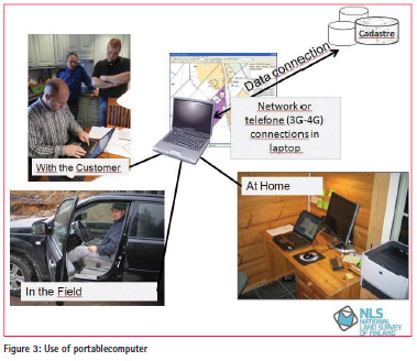
Technological development has changed the story above. Cadastral surveyors have portable computers and all the information systems that are available at the office are also available in the terrain. Surveyors can maintain the Cadastre from anywhere and use any telecommunications network by using Citrix–technology (Figure 3).
A cadastral surveyor can go to the customer straight from home or even from his cottage. With the customer he can store legal cadastral survey information directly using the Cadastre maintenance application. At the end of day he come back to home and stores this day’s information in the system. He can e.g. send documents and invoices to customers and update the Cadastre.
This procedure speeds up legal cadastral surveys and affects the quality of work positively, because surveyors can update the Cadastre on the same day, when the day’s case is in good memory. It is also notable that information is updated by the same person who has collected and handled it in practice.
This arrangement has contributed to better performance in the cadastral survey process and to time savings. The surveyors have been able to better integrate work and leisure time when they can work in any place at any time. This has meant better wellbeing at work for surveyors. In addition the mobile work is environmentally friendly, because it reduces the need to drive.
Activity based work, common working place and flexible working time
Only a small part of working tasks at the NLS is bound by a fixed location; such could be working in customer service or working with special technical instruments like a digital stereo workstation. Almost all other work can be done in any location. A video connection is a natural way to communicate. Workers at the NLS engage in activity based work. Technology has made it possible to work at home, in a hotel, municipal hall, or anywhere.
Office premises cause big costs and the characteristics of the work have also changed, which have made it necessary to investigate office space utilisation. Work is more mobile and can be done anywhere. We work at the customer’s home or from home, when we go to our workplace we often sit in meetings or we are absent from the office. At all these times our own office or cubicle is empty. New offices at the NLS are furnished so that no one has his own room or seat. Employees have locker for keeping their work things and every day employees find a free place where to sit. This is the way to reduce offices sizes and save costs of office premises.
In NLS, we do not have fixed working times. Of course we have functions where it is necessary to be present during office hours (8:00 to 16:15) and many others are present at the same time. But we have the opportunity of working between 6:00 and 23:00. This we call flexible working time. It increases the possibilities to arrange the work schedule to fit personal conditions and opportunities.
Structure of organisation
At the NLS the Cadastre is updated in four processes. Basic surveys (parcelling out and private road surveys) are in one process, valuation surveys in another process, land consolidations are in a third and other maintenance of the Cadastre in a fourth process.
Production at the NLS has taken place in processes for the last 15 years, which have ensured a homogeneous mode of action and uniform quality. From the beginning of the year 2014 we develop our process organisation one step further. Now our production operates at a national level without any regional level, and the district survey offices no longer exist. Each national level process is its own result unit which has total responsibility of production regarding result, income, worker resources and quality.
Working in a national level organisation in each process has made it easier to move the work force where it is needed because the borders between district survey offices no longer exist. At the same time many functions are also centralised at a national level. This means that exceptional and rarely occurring cadastral surveys or those which need expert knowledge are done by surveyors with specials kills.
In conclusion
ICT tools are a part of today’s working environment. Work flows can be developed quite far so that system users, like cadastral surveyors, work becomes easier, more effective, productive and at the same time the quality improves. Employees can do their work anywhere, which increases the meaningfulness of their work and their wellbeing at work.
Working in an electronic world demands also that working conditions and working environments change to meet the requirements of working in new way. In Finland we have developed our processes and organisation trying to improve our productivity.
Development is a never ending process. Now we consider how we can better serve customers in an electronic world. It is also time to consider the requirements that we demand of the next generation Cadastre, as quite many countries have done in conjunction with the Cadastre 2034 programme. We have to think of the opportunities provided by technical development, but maintenance processes, operation environment and even organisations may require changes.
References
Tuomaala, J., Uimonen, M.: Introducing the New Object-Oriented Cadastral Information System (JAKO) of Finland. FIG congress proceedings, Brighton,1998
Tella, A.: The New Land Information System in Finland. FIG congress proceedings,Munich, 2006
The paper was presented at FIG Working Week 2015, Sofia, 17-21 May 2015


 (13 votes, average: 1.46 out of 5)


Leave your response!