Articles in the Articles Category

The authors spent two years research on the application of the (Mahalanobis-Taguchi Method) MT method for earthquake prediction which shows interesting result
Shunji Murai
Chief Technical Officer, Japan Earthquake Science Exploration Agency (JESEA), Tokyo, Japan
Shoichi Teshima
President, Angletry Co., Ltd. Sapporo, Japans
JESEA (Japan Earthquake Science Exploration Agency), which celebrated its fifth anniversary since establishment in January 2013, continues …

Pause and re-plan!
A recent study
‘Satellite-derived Time and Position: A Study of Critical Dependencies’
by The UK Government Office for Science
Reviews the UK’s dependency on GNSS
And recommends measures to improve resilience
Including by adopting potential back-up systems.
More than the findings,
The worth appreciating is the approach.
The approach of ‘a pause’
Where …

Car to caravan
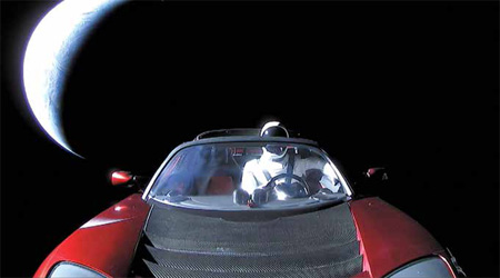
Another feat of mankind.
Falcon Heavy by Sapce X symbolizes
The dreams and the dreamers.
Imagination, inventiveness and ingenuity.
A journey from surrealism to reality.
It was not Falcon Heavy alone,
Along with it was Tesla Roadster.
A craft, along with a car.
Will it eventually be followed by a caravan?
Who knows!
Bal …
March 2018
Munich Satellite Navigation Summit
5 – 7 March Munich Germany
http://www.munich-satellitenavigation-summit.org
EUROGEO 2018
15 – 17 March
Cologne, Germany
http://www.eurogeography.eu
Gi4DM 2018
18 – 21 March
Istanbul Technical University, Turkey
http://www.eurogeography.eu
United Nations/Argentina Workshop on the applications of GNSS
19 – 23 March
Falda Del Carmen, Argentina
http://www.eurogeography.eu
April 2018
The 7th …

Takeyasu SAKAI
Principal Researcher, Navigation Systems Department, Electronic Navigation Research Institute, National Institute of Maritime, Port and Aviation Technology, Japan while sharing the status and prospects of QZSS and MSAS programmes
Please update us with the status of QZSS.
Following QZS-1 launched in 2010, additional three satellites has been launched in 2017 to complete the initial constellation of …


 (5.00 out of 5)