Articles in the Articles Category

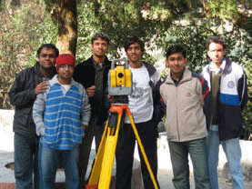
Survey Camp, Nainital was held from 28th November – 7th December, 2008 as part of the academic curriculum at IIT Kanpur. The site chosen for the camp was Nainital which is set in a valley containing a pear-shaped lake and is bounded by a great snowy range which forms the central axis of the Himalayas …
Showcase of New GNSS Era
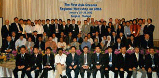
The First Asia Oceania Regional Workshop
Jan 25-26, 2010, Bangkok, Thailand
The First Asia Oceania Regional Workshop was held on January 25 and 26 at Sofitel Centara Grand Bangkok, Thailand. The workshop was hosted by SPAC, JAXA and GISTDA as well as supported by United Nations International Committee on GNSS (UN ICG). The …

Decade of Innovations – 2010 – 2020
The Government of India has declared so.
Indian Science needs money.
It also needs a change in mindset.
The country needs to develop an innovation eco-system.
Where innovators can produce newer solutions.
To meet the needs of society.
However, the need is to liberate Indian science.
From the shackles and deadweight of bureaucracy and in-house favouritism.
The …
March 2010
Munich satellite navigation Summit
9-11 March
Munich, German
www.munich-satellite-navigation-summit.org
Geoform+’2010
30 March- 2 April
Moscow, Russia
www.geoexpo.ru
Digital Preservation of Archaeological Heritage
10-12 March, 2010
IIT Kanpur, Kanpur, India
arch3d@iitk.ac.in
www.iitk.ac.in/arch3d
CARIS 2010
22-25 March
Miami, Florida, USA
www.caris.com/caris2010
April 2010
XXIV FIG International Congress 2010
11 – 16 April 2010
Sydney, Australia
www.fig2010.com
Geo-Siberia 2010
27-29 April
Novosibirsk, Russia
www.geosiberia.sibfair.ru
ASPRS 2010
26-30 April
San Diego, CA, USA
www.asprs.org/SanDiego2010
May 2010
TIDES 2010
20-21 May
Taipei, Taiwan, R.O.C.
derc@mail.pccu.edu.tw
International Conferences on Integrated Navigation Systems
31 May -02 June …
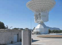
For interplanetary missions, the determination of S/C state vector (position and velocity) is required both for navigation purposes and science operations. The main error sources affecting S/C tracking data are the solar corona and the interplanetary plasma, which could be removed by using the multifrequency link technique between the probe and the ground station [1]. Once solar plasma noise has been removed…

The NSDI Annual event, NSDI-9 is around the corner. What has been the progress of NSDI in the past year?
The major achievement during the intervening period is release of NSDI metadata standard ver.2.0. The earlier version was brought out before ISO (TC.211)/OGC, released the standard on metadata ISO 19115. Now, this standard conforms to the international standards. Taking the SDI a step forward, the Karnataka Geo-portal of Karnataka Spatial Data Infrastructure is being launched during NSDI-9 and Delhi Geoportal has already been launched in November 2009. Kerala has sanctioned the requisite resources for creating Kerala State SDI. The process of building Kerala Geo-portal is on and the RFP is already issued.

What is your vision with regard to Trimble expansion plan in India?
Our vision is to determine the challenges that our Indian customers are trying to solve in the Utilities, Construction, Infrastructure, Mobile Resource Management, GIS and Mapping, Public Safety and Surveying industries to develop localized software and hardware solutions that meet their needs for increased productivity and reduced rework. We offer solutions that have been proven worldwide and now we must determine if these solutions meet the needs of the Indian customer. Where the solutions do not meet their needs or requirements we must adapt them so they can provide our customers maximum productivity advantages. We can accomplish this by adding resources in our Delhi and Chennai offices in marketing, R&D and sales. Where we find it necessary to create or integrate new solutions to address the unique needs of the Indian market,

It had a gloomy start. With uncertainties and apprehensions. Disappointments and cynicism.Many whom we banked on went bankrupt.It was also the time.To change thinking, strategies and approach.

Ownership and long term leasehold are the most important rights in land. The actual content of these rights may vary between countries and jurisdictions, but in general the content is well understood. Rights to land also include the rights of use. This right may be limited through public land use regulations and restrictions, sectoral land use provisions, and also various kind of private land use regulations such as easements, covenants, etc…
January 2010
Asia Oceania Region Workshop on GNSS
25-26 January 2010
Bangkok, Thailand
www.multignss.asia/workshop.html
March 2010
Munish Satelite Navigation Summit
9-11 March
Munish, Germany
www.munish-satelite-navigation-summit.org
GEOFORM+’2010
30 March -2 April
Moscow, Russia
www.geoexpo.ru
Digital Preservation of Archaeological Heritage
10-12 March, 2010.
IIT Kanpur, Kanpur, India
arch3d@iitk.ac.in
www.iitk.ac.in/arch3d
CARIS 2010
22-25 March
Miami, Florida, USA
www.caris.com/caris2010
April 2010
XXIV FIG International Congress 2010
11 …


 (5.00 out of 5)