


Using cryptographic digital technology, a mobile application could be developed to eliminate property registry fraud even before it occurs
Jethro Jones
Medici Land Governance, Utah, USA
Abstract
Property registry fraud is a form of identity theft used to steal property by forging documents in the name of the property’s rightful owner. Property registry fraud impacts land rights across the …

An experimental course of C++ programming for surveyors and cartographers has been developed and implemented in the educational process at Moscow State University of Geodesy and Cartography. The C++ programming course focuses on the use of cartographic tasks and geodetic exercises to illustrate various programming language constructions. One of these training computer programs is discussed. …


Volume XVIII, Issue 1, January 2022
Let the Metaverse v/s Omniverse race begin!
Graeme Hooper
Technology trend in 3D mapping systems for mining
Giorgio Vassena
5 ways drones are improving workplace safety standards
James Rennie
High-accuracy augmented positioning services will become the new normal
Guy Buesnel
Geo-spatial big data analysis of Covid-19 spectrum envelope of first and second wave of the outbreak in …
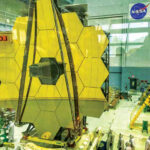
James Webb Space Telescope
The telescope,
A joint international collaboration led by NASA in partnership with the European and Canadian space agencies,
Developed at a cost of $8.8 billion,
Was successfully launched on 25th December 2021.
Unlike its 30-year-old predecessor, the Hubble Space Telescope, operated primarily at optical and ultraviolet wavelengths.
Webb mainly will view the …
March 2022
Munich Satellite Navigation Summit 2022
7-9 March Munich, Germany
munich-satellitenavigation- summit.org
IGRSM 2022
8-9 March Virtual Conference Kuala Lumpur Malaysia
https://www.igrsm.org
The 10th Land Administration Domain Model Workshop
31 March – 2 April 2022 Dubrovnik, Croatia
http://isoladm.org/LADM2022Workshop
July 2022
IGARSS 2022 (hybrid form)
17-22 July 2022 Kuala Lumpur, Malaysia
https://igarss2022.org
September 2022
Commercial UAV Expo Americas
6-8 September 2022 Las Vegas, USA
www.expouav.com
October 2022
Intergeo Hybrid
18-20 October 2022 Essen, Germany
www.intergeo.de
November 2022
Trimble …
R750 – New GNSS base station
Trimble has introduced the R750 GNSS Modular Receiver, a connected base station. It can be used to broadcast Real- Time Kinematic (RTK) corrections for a wide range of applications, including seismic surveying, monitoring, civil construction, precision agriculture and more. Access to all available satellite signals provides improved performance and reliability …
Multiclass object detection algorithms for ships, aircraft and vehicles
Orbital Insight has launched multiclass object detection algorithms within its GO platform. It uses advanced computer vision algorithms to identify and differentiate between classes of ships, aircraft and vehicles within satellite imagery. The state-of-the-art multiclass ship detection algorithms will bring immediate benefits to the defense and …
CHORUS Earth Observation mission
MDA Ltd has announced its next generation commercial Earth observation (EO) mission will be named CHORUS. It will initially include C-band and X-band Synthetic Aperture Radar (SAR) satellites. A collaborative multi-sensor constellation, CHORUS will bring together multiple diverse and unique perspectives in harmony, opening the aperture and the art of the possible …

ISRO and OPPO India to work towards providing NavIC messaging services
NavIC system, in addition to its primary function of providing PNT services, is also capable of broadcasting short messages. This messaging service is being used for broadcasting safety-of-life alerts in areas with poor or no communication, particularly in the oceans.
Indian Space Research Organisation has entered …


 (5.00 out of 5)