It is not just having computers in offices or creating websites, but it involves the creation of systems; integrating technology with administrative processes; human resources and dispensing information and services faster to the citizens. e-Governance offers a number of advantages for the government as well as the public. It shifts the centre of power from human agencies to technology, which is easier to deal with. For example, if a citizen wants some information on building codes, he/she has to go to the office of the local authority to get it, often shuttling from one table to another. If such information is made available on websites, it makes things easier for the citizens as well as the authorities.

SVLBI (Space Very Long Baseline Interferometry) is an extension of the ground-based VLBI into the space. It has some important potential applications in geodesy and geodynamics, including the definition, practical realization, and the interconnection of different reference frames, determining the geocentric positions of VLBI stations, estimation of the gravity field of the Earth, and satellite orbit determination using the delay and delay rate observables.
It is not simply a project.
It is an ambition.
An assertion of technology.
And taking the technology beyond the realms of monopoly.
There are hurdles. Political and economical.
But stronger is the will to overcome them.
There are confl icts. On approach and interest.
There are frustrations on the delay. And, at stake is the credibility.
Still, there is a resolute to …
October 2007
36th Annual ILA Convention and Technical Symposium!
October 14-17, at the Embassy Suites Orlando International
Drive Orlando, Florida, USA
9th South-East Asian Survey Congress
28 October – 2 November,
Christchurch, New Zealand
http://www.conference.co.nz/ index.cfm/surveyors2007/The
Nav 07 Navigation Conference & Exhibition
30 Oct 2007 -01 Nov 2007
http://www.rin.org.uk
conference@rin.org.uk
27th INCA International Congress
Visakhapatnam, India
21-23 November 2007
www.hydrobharat.nic.in/Ist_Circular_INCA_2007.pdf
14th Session of the Asia-Paci?cRegional Space Agency Forum
21-23 November
Bangalore, India
www.aprsaf.org/text/ap14_info.html
ESRI …

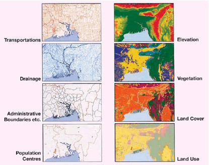
THE United Nations Conference on Environment and in Rio de Janeiro recognized the need to coordinate environmental data and spatial information as an aid to decision making in formulating responses to the challenges of global environmental change and to support sustainable development. The concept of Global Map as a means of doing this was introduced by the Government of Japan and became a formal part of the Agenda 21 action plan. Global Map is a digital map of the world at the scale of 1:1 million which is produced by a cooperative effort of the national mapping organizations of the world. At the time of writing (May 2007) 172 countries and regions were involved in the creation of Global Map. Global Map has eight data layers, four in vector format and four in raster format. These are transportation, boundaries, drainage, population centres (in vector format) and elevation, vegetation, land cover and land use (in raster format).

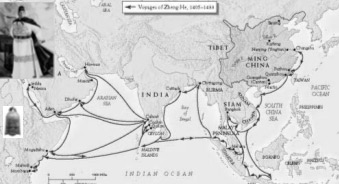
Zheng He’s Exploration of the Western Pacific Ocean and the Indian Ocean was an important event at the turning point of the world history. It was a golden opportunity for China to strengthen itself and make greater contributions to human beings. Unfortunately, to some extend, Zheng He’s magnificent feat in the history of navigation was later considered as a sheer waste of energy and money and a “failure policy”, and thus was put an end to. Zheng He’s trip, therefore, did not produce long-term effects. China still cut off itself from the out side world and stopped her exploration of ocean navigation, while Europeans, along the routes opened up by their expeditions, reached America, Africa and Asia and established colonies all over the world, which greatly promoted the capitalist development. In spite that the scale of Zheng He’s navigation far exceeded that of Columbus’s “Great Discovery” which followed some 80 years afterward, the former had much less effect on the progress of the world history.

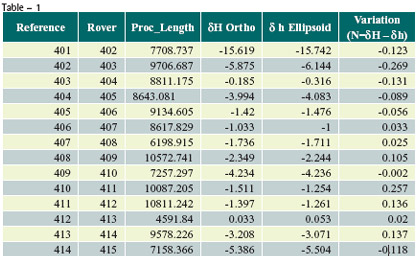
CURRENTLY the trend is that more and more project authorities are mandating use of GPS for control work and private surveyors have to comply with this requirement. Dual frequency DGPS have been beyond the financial reach of these surveyors as such most prefer to invest in single frequency DGPS, which cost almost one third the cost of dual frequency DGPS.

Galileo to support global search and rescue
The detection of emergency beacons will be greatly improved by the introduction Galileo. It will carry transponders to relay distress signals to search and rescue organisations. In connection with this, representatives of the Galileo project attended the recent 21st annual Joint Committee Meeting of COSPAS-SARSAT, the international programme for satellite-aided search and rescue. The partners in Galileo are committed to developing the Galileo search and rescue component as an integral part of MEOSAR (Medium Earth Orbit Search And Rescue, the future worldwide search and rescue satellite system. Galileo joined the meeting in a formal capacity as a major contributor to the MEOSAR programme, following the signature of the ‘Declaration of Intent to Cooperate on the Development and Evaluation of MEOSAR’. It is a programme to equip satellites that operate in medium- Earth orbits with payloads that receive signals from distress beacons on Earth. These signals are then relayed to rescue organisations, giving them the location of the emergency.
www.gpsdaily.com

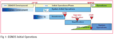
THIS paper describes of the activities performed by the European Satellite Services Provider (ESSP) and its partners in the establishment of the EGNOS system operations organization, the implementation and utilization of the operations processes and procedures and the operations products baseline as well as describing the management processes used within EGNOS operations with respect to preparation for Safety of Life Services.

ACCORDING to a recent Eurobarometer opinion survey, Europeans are highly positive about the GALILEO program, which aims to develop Europe’s own satellite-based navigation system. The survey indicates that most of EU citizens are aware of the role global positioning systems play in their everyday lives, know about possible applications and are firmly behind the development of such new technologies.
Furthermore, an overwhelming majority consider that Europe should set up an independent navigation system even if this involves securing additional public funds.


 (5.00 out of 5)