

Study GIS at Hong Kong Polytechnic
The Department of Land Surveying and Geo-Informatics at the Hong Kong Polytechnic University is now accepting applications for Master of Science/ Postgraduate Diploma in Geomatics (GIS/ Surveying). It is the longest running postgraduate program in GIS and the only one in Geomatics (Surveying) in Hong Kong. www.lsgi.polyu.edu.hk

Safe Navigation in Korea
In Korea, the Ministry of Land, Transport and Maritime Affairs shall soon provide small ships off the coast of the Korean peninsula with differential GPS information through mobile phones and other personal devices. Until now small avoided using professional equipment because of the price of the hardware. http://english.mltm.go.kr

Different strokes
Akio Yasuda, Al Stevens, Chirs Goodall, Naser El-Sheimy, Orhan Altan, Frank Derby, George Cho, Brent A Jones, Dietrich Schroder, P Mishra
Adding dimensions to the domain
Malaysia precise positioning
Norsuzila Ya’acob, Mardina Abdullah and Mahamod Ismail
SPATIAL needs political champions
Gary Nairn

Almost 20 years ago, as a Surveyor in private practice, and as someone who had a passing interest in politics, I presented a paper at a surveying conference, titled “Surveying the Political Landscape. At the time I had no ambition to stand for political office as I was more than fully occupied with my Surveying and Mapping business which was busy adopting new technologies such as Geographic Information Systems and Global Positioning Systems…
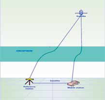
Global Positioning System (GPS) is currently one of the most popular global satellite positioning systems due to global availability of signal and performance. GPS employs two carrier frequencies which is L1 and L2 allowing receivers equipped with dual frequency operation to be used. Due to the inhomogeneity of the propagation medium in the ionosphere, the GPS signal does not travel along a perfectly straight line [1,2]…
Report on 3rd Land Administration Forum 24-26 May 2009-Tehran, Iran
The UN sponsored Permanent Committee …

How can we plan and decide upon urban growth?, which house to buy as a secure investment?, which properties are at risk? All these are critical questions we have to face in a changing world and that may affect permanently our lives. For this reason, today it is much more important to make the correct decisions, whether for designing the national economy or making personal plans for the future.
Making decisions requires knowledge,…

GPS/INS integrated navigation system has been a candidate of integrity monitoring system since an inertial sensor could improve performance of the fault detection and exclusion (FDE) functions. Japan Aerospace Exploration Agency (JAXA) has developed several GPS/ INS systems called GAIA (GPS Aided Inertial navigation Avionics) for over ten years and succeeded in automatic landing of unmanned experimental…

Transport of people and goods is one of the pilars of civilisation. The
exchange of goods, services and ideas is in foundation of modern economy, as well as it was in the past. However, growing population generates new challenges for traffic control that leaves no space for classic solution but calls for the innovative and multidsciplinary approach based on the latest scientific and technology achievements…

Is it curtains for Loran?
It is a seamless backup to GPS.
It is cost-effective and completely interoperable.
Asserts The Independent Assessment Team (IAT).
Also, recommends unanimously to US Government.
To complete the eLoran upgrade and commit it as the national backup to GPS.
Two leading Senate Committees also publicly back the eLoran system.
Reportedly, $ 160 million investment has already been …


 (5.00 out of 5)