

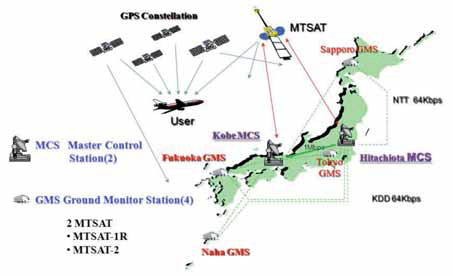
The Multi-functional Satellite Augmentation System (MSAS) is a Japanese Satellite Based Augmentation System (SBAS) [1] which provides Differential GPS (DGPS) corrections and is designed to supplement GPS by reporting and monitoring the reliability and accuracy of GPS signals in real time. MSAS consists of two satellites, (MTSAT-1R at 140E longitude and MTSAT-2 at 145E longitude), four Ground Monitor Stations (GMS), two Master Control Stations (MCS),…

Could you highlight the strengths of Vexcel Imaging large and medium format camera’s for our readers.
The strength of Vexcel is outstanding market knowledge, unparalleled technical experience and the attitude for innovation, all combined to maximize the customer benefi t of our products. Vexcel entered the market of digital large format aerial cameras in 2004, about three years later than the competition with a new concept, the UltraCam. Since then we have increased our market share constantly and became the market leader quickly – we have sold more than 125 UltraCams and additionally quite some camera upgrades. Obviously the market has decided for frame cameras and has made the UltraCam the most successful large format camera series.
Is the name DAT/EM an acronym, or is there some other signifi cance behind it?
DAT/EM (pronounced dāt’-əm) is an acronym for Digital Automated Technology / Engineering Mapping. The software was developed internally between 3 production mapping fi rms located in the United States in the mid 1980’s. As such, our software was conceived in a production environment to meet the demanding technical needs of top-fl ight photogrammetric organizations. Since the fi rst data collection licenses were sold in 1987 (on analogue stereoplotters), we have never lost sight of the need for constant improvement of the software. We have always understood if the software tools can save a user one key-stroke (or more!) on a repetitive command, this will have a direct and positive infl uence on the company’s profi tability.
August 2009
Bentley Be Connected Online Seminars
23 July-30 Nov.
www.bentley.com/BeConnected
September 2009
2nd GNSS Vulnerabilities & Solutions Conference
Sept 2 to 5, 2009
Baska, Krk Island, Croatia
http://twitter.com/BaskaGNSS2009
Telespazio takes control of Galileo Ground Facility
Telespazio has taken over management of a Galileo satellite constellation control centre. The company will begin cabling the entire structure as well as installing and integrating required systems and equipment for the satellite constellation and mission. Telespazio said its work will begin on the areas dedicated to security, navigation signal generation systems, orbital management and atomic clocks. The control centre is expected to be fully operational and will be inaugurated this fall. www.telespazio.it
ISRO gets 40% more funds
India’s space research programme recently got a signifi cant 40% boost from the union budget for 2009-10. The bulk of the funds will be used in ongoing projects like development of the GSLV Mark III. www.domain-b.com
OGC calls for Industry input on Geospatial Fusion
The Open Geospatial Consortium (OGC®) has issued a Request for Information to solicit industry input into a Fusion Standards Study to be conducted in preparation for the planned OGC Web Services, Phase 7 (OWS-7) Testbed. It will also partner with other Standards Development Organizations (SDOs) having technology relevant to fusion. www.opengeospatial.org
Delhi 3 months away from geogovernance
For the first time ever Delhi city will have a utility map through aerial photographs and also real-time monitoring of the ground situation throughout the city with the help of 64 wireless internet protocol cameras. 31 departments and agencies will be able to access this data in real time. The Rs 120 crore project called the Delhi State Spatial Data Infrastructure (DSSDI) project is in the last stages of completion. It is being done by Delhi government along with Survey of India (SOI). Times of India
Indian GPS augmentation goes ahead
ISRO has awarded an $82 million contract to Raytheon to build the ground stations for the GPS-Aided Geosynchronous Augmented Navigation (GAGAN) System. GAGAN will provide satellitebased navigation – nominally for civil aviation, but in practice for all users – over Indian airspace and adjoining areas in South and East Asia. It is a satellite-based augmentation system (SBAS) for GPS and other operational satellite navigation systems giving differential corrections. It is scheduled to be fully functional by 2013. http://raytheon.mediaroom.com
SatGuide PND Moov 300
SatNav Technologies launched the SatGuide PND Moov 300 in India. It will provide road navigation with features like voice prompted directions and a 4.3-inch touch screen. www.satnavtechnologies.com
4.7-inch Maestro PND by Magellan
Magellan announced the Maestro PND with new design, 4.7-inch Display, voice command capabilities, handsfree Bluetooth calling and highway lane assist. It has new feature “Find Your Car” which remembers the location of your car. http://promagellangps.com
Ordnance Survey works with GRACE
GRACE – the GNSS Research and Applications Centre of Excellence – has recently worked with Great Britain’s national mapping agency, Ordnance Survey. A team from GRACE carried out data collection at various sites to test potential new GNSS survey equipment. www.grace.ac.uk
Leica CloudWorx™ 1.0 for SmartPlant
Leica CloudWorx™ 1.0 for SmartPlant 3D was recently released by Leica. It is designed for Intergraph SmartPlant 3D users who want to take full advantage of accurate, laser scan asbuilt data directly in SmartPlant 3D. Leica has also released the QuickSteer motor – a new retrofi t option for farmers who want to add auto-steer functionality to their older tractors. It can be added to a wide range of agricultural vehicles that do not have factory-installed steering kits. www.leica-geosystems.com


 (5.00 out of 5)