

It was in the late 1950s that the Tellurometer hit the surveying profession. Certainly it was not the first EDM instrument on the market, that title goes to the Geodimeter which appeared in 1947, but there was a difference. The Geodimeter worked on a light source and as such its maximum range was limited by visibility. The Tellurometer operated on a radiowave which could penetrate most weather conditions and achieved distances up to 100 miles…
January 2010
Asia Oceania Region Workshop on GNSS
25-26 January 2010
Bangkok, Thailand
www.multignss.asia/workshop.html
March 2010
Munish Satelite Navigation Summit
9-11 March
Munish, Germany
www.munish-satelite-navigation-summit.org
GEOFORM+’2010
30 March -2 April
Moscow, Russia
www.geoexpo.ru
Digital Preservation of Archaeological Heritage
10-12 March, 2010.
IIT Kanpur, Kanpur, India
arch3d@iitk.ac.in
www.iitk.ac.in/arch3d
CARIS 2010
22-25 March
Miami, Florida, USA
www.caris.com/caris2010
April 2010
XXIV FIG International Congress 2010
11 …
Inauguration of Galileo station at Kourou
The site of a ground station for Galileo inside the Guiana Space Centre (CSG), near Kourou in French Guiana, has been inaugurated. The site, which was made available by France’s Centre national d’études spatiales (CNES), will play an essential role in the setting up of the Galileo system, since it will accommodate the most comprehensive of the Galileo ground segment stations. The Kourou station will consist of a telemetry, tracking and command (TT&C) station to monitor and control the Galileo constellation satellites, a sensor station (GSS) for acquisition of the satellite navigation signals, and two uplink stations (ULS) for transmission of navigation and integrity messages to the satellites. In all, the Galileo ground segment for the in-orbit validation phase (IOV) will comprise 18 sensor stations,
TurboGPS wireless service in S Korea
u-blox and FINEDIGITAL Inc. has launched a wireless accelerated-GPS service “TurboGPS”. It provides GPS aiding data to vehicle and PNDs throughout South Korea and is available to 3rd party manufacturers of GPS products. www.u-blox.com
Vehicle Tracking in Papua New Guinea
MapData Sciences (MDS) and Data Nets Limited shall be providing current digital mapping and live fleet tracking services in Papua New Guinea (PNG). One of the first applications shall be to protect the fuel tankers and their cargo for a major energy provider in the region, by allowing them to utilise GPS tracking devices and real time monitoring of the vehicles. www.mapds.com.au
Maritime: 10 Nov, Southampton
Positioning & Location:12 Nov, Nottingham
Land:19 Nov, Teddington
Timing: 20 Nov, Teddington
Air: 25 Nov, London
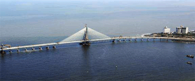
Introduction The Bandra-Worli Sea Link (BWSL) is a civil engineering marvel spanning an arc of the Mumbai coastline. With its cable-stayed towers soaring gracefully skywards, the sea link is a reflection of the modern infrastructure that Mumbai is adding in its progress towards becoming a world-class city…

Many of the world’s volcanoes that erupt, experience significant preeruption surface deformation. Internal magma pressure makes the surface bulge upwards and outwards. Thus, precise monitoring of surface deformation has the potential to contribute significantly to the realisation of a predictive capability of volcanic eruption. In particular, eruption source depth and evolution time can be estimated from surface deformation…

ll countries have to deal with the management of land. They have to deal with the four functions of land tenure, land value, land use, and land development in some way or another.
National capacity may be advanced and combine the activities in one conceptual framework supported by sophisticated ICT models. More likely, capacity will involve very fragmented and basically analogue approaches…

Landslide is a common hazard in the hilly regions which causes heavy losses to life and properties every year. Since 1980 various researches and analyses have been carried out in the GIS environment to identify factors responsible for causing landslides. The important conditioning factors identified by the researchers are slope, geological, geomorphologic structures and land use coupled with triggering factors like rainfall and a few of the anthropogenic activities…
November 2009
INCA 2009
25-27 November
Kolkata, India
http://www.incaindia.org
ISPRS (Geospatial Data Cyber Infrastructure)
25-27 November
Hyderabad, India
http://www.incois.gov.in/isprs


 (5.00 out of 5)