


The U.S. Department of Transportation’s Federal Aviation Administration (FAA) released on November 7, 2013 its first annual Roadmap outlining efforts needed to safely integrate unmanned aircraft systems (UAS) into the nation’s airspace. The Roadmap addresses current and future policies

Bhuvan (www.bhuvan.nrsc.gov.in), a unique geoportal of NRSC that provide diversified geospatial services, is gaining popularity day by day and is much appreciated for its dynamic services. Initiated in 2009, Bhuvan has grown up rapidly and has made its impact on Indian user community. Expanding it’s state-ofart facilities and a datacentre at Hyderabad, Bhuvan is now extending geographically with its distributed architecture.
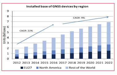
On the 15th of October 2013 the European GNSS Agency (GSA) released the latest version of its GNSS Market Report. The Market Report brings an updated and enhanced view of the GNSS global market “as it is experimenting rapid developments”. It encompasses a larger scope than before

In areas such as the environment of the city, for reasons such as multipath and GPS signal blocking, accurate position estimation is difficult only GPS system. The study such as GPS/INS, GPS/DR has been performed. Location estimation technique that combines vehiclemounted sensors, camera

China has invested enormous effort in manned space engineering. The Tiangong-1 and Shenzhou-8 have been launched, twice rendezvouses have been accomplished successfully. In order to meet the requirements of the manned space engineering on the TT&C network, and prepare for our country’s space station construction

Potential conflicts between customary and / or informal systems of land tenure with the state supported formal systems of land registration are an issue in many developing regions. Africa presents a significant challenge because the traditional authorities (chiefs, clans, families etc.)

“We were impressed with thesoftware’s capability and processingtimes. The results achieved were notonly produced quickly, but with a highdegree of accuracy”- Mr. Mohamad El Kadi, Managing Director of Space Imaging Middle East

America freezes and Australia sweats.
With weather becoming more chaotic than erratic
The consequences of climate change
Appears to be getting worse


 (5.00 out of 5)