

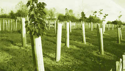
Where to plant a trillion trees to save planet Earth?
Restoration of forests has long been seen as a potential measure to combat climate change. The latest special report by the Intergovernmental Panel on Climate Change suggests that an increase of 1 billion hectares of forest will be necessary to limit global warming to 1.5°C …

Precise Point Positioning (PPP) is a versatile tool that has drawn attention among researchers in processing static and kinematic…

For over 20 years, governments in developing and developed countries have invested worldwide on improving the certainty of rights, restrictions and responsibilities by implementing land tenure reform projects…

Diurnal Total Electron Content (TEC) variations prior to Mw 6.2 Tajikistan Earthquake of 9th May 2018 were investigated for pre earthquake…

Among the approximately 2.5 billion tonnes of solid waste produced globally in 2010, about 275 million tonnes was mismanaged plastic…

Volume XV, Issue 6, June 2019
Zip
Privacy and ethics under the gaze of eyes in the sky
George Cho
Advancement in GNSS technology in India
Sanat K Biswas
Building a low cost long range mapping drone
Sasanka L Madawalagama, Hiroshi Inoue, Chathumal M Weththasinghe Arachchige , Manzul K Hazarika, Kavinda Gunasekara, Treshan N Perera and Manuka P Gunasekara
Driving force of historically …

Protecting privacy
When a trade off is made
Between convenience and personal information
We not only underestimate the value of the information
But many a times underestimate its potential exploitation, as well
And we do not realize when and how
The technology that otherwise is pushed as a facilitator,
Turns into a surveillance tool.
Is it true that in bio-techno sphere
Where we live …
June 2019
United Nations/Fiji Workshop on the applications of GNSS
24 – 28 June 2019
Suva, Fiji
http://www.unoosa.org
July 2019
Esri User Conference
8 – 12 July
San Diego, California
https://www.esri.com
August 2019
Nine-month post graduate courses on Global Navigation Satellite Systems (GNSS) and Satellite Communications (SATCOM)
1 August 2019- 30 April 2020 Space Applications Centre (SAC), Ahmedabad, India
www.cssteap.org, www.sac.gov.in
Smart Geospatial Expo
7 – 9 August Seoul, Republic …
ViaLite GNSS/GPS Fiber Extension Kit
Carrying timing signals over optical fiber links to 10+ km, ViaLite’s new GNSS/GPS Fiber Extension Kit has been successfully qualified for use with Microsemi’s timing and synchronization products. Included in the kit is the ViaLiteHD GPS Link, which is ideal for providing a remote GNSS/ GPS signal or derived timing …


 (5.00 out of 5)