Articles in the Mapping Category


This paper is an extract from the author’s book Mapping: Past, Present and Future
Ashok Kumar Jain
ak. jain6@gmail. com Worked as Commissioner (Planning), Delhi Development Authority and as a member of the Committee of the Ministry of Housing and Urban Affairs on the DDA (2015). He was a member of UN Habitat (2007-12). He was awarded …

Since 2014, IGN has been monitoring advancements in technology to explore a colour relief printing service for on-demand mapping
François Lecordix
National Institute of Geographic and Forest Information, France
Abstract
By following advancements in 3D printing technology, IGN explored an inkjet-based relief printing solution proposed by the Océ company in 2015. The initial results were presented at the International …

In Ubiquitous dimensions, the notion of a “map” must be replaced with “mapping,” as users demand real-time creation and manipulation of maps in a digital society
PEPPLE, Godwill Tamunobiekiri
Department of Surveying and Geomatics, Faculty of Environmental Sciences Rivers State University Port Harcourt, Nigeria
UDOH, Ofonmbuk Jeremiah
Office of the Surveyor Genera Delta State, Asaba, Delta State, Nigeria
WEST, Emilia …

Data has been utilised in generation of tsunami models at local scale for different magnitudes of earthquakes, preparation of multi hazard vulnerability maps for oceanogenic disasters, to assess disasters at micro-level and planning the mitigation
B Sadasiva Rao
National Remote Sensing Centre (NRSC), Hyderabad, India
G Varaprasad Babu
National Remote Sensing Centre (NRSC), Hyderabad, India
B Laxman
National Remote Sensing Centre …

Nine determining parameters identified in this study to identify suitable site for the industrial establishment
Muluneh Beyene Tsala
Department of Land and Real Property Valuation, Dire Dawa University, Ethiopia
Abstract
The significance of GIS and Remote Sensing techniques and technologies currently in every aspect of human beings day-to-day activities initiated the researcher to conduct this study. Industry is important …
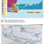
The aim of this research is to produce a new and updated map Lagos Island Local Government Area, Nigeria and document changes that have occurred over time
Leonard Michael Onyinyechi Aminigbo
Department of Geography and Environmental Management, Rivers State University, Portharcourt, Nigeria
Abstract
The scope of the research work comprised the planning and preliminary data requirement analyses, acquisition of …

No, India’s forest cover has not increased steadily. Instead, tea estates, coconut plantations, and even tree-lined avenues are being classified as forests
M D Madhusudan
Ecologist
T R Shankar Raman
Ecologist
It is not long after dawn, but the air in the Borajan rainforest in upper Assam is already warm and heavy with humidity. On a fig tree by the …

The paper describes a method for improving the coordinates of hydrological stations using the GNSS. Traditional methods of determining the coordinates of level posts are analyzed in this work. The requirements for the accuracy and installation of geodetic points of level posts are given. A scheme of the GNSS network of the coastal zone…

The development of the modern Greek cadaster has been a long standing objective for every Greek government since the early 19th century in order to replace the existing oldfashioned individual based system…

The environment for seagrass to grow is in marine ecosystem. Providing habitat for marine biota is the seagrass’ primary role. Aside from that, seagrass is also able to absorb and store carbon, thus reducing CO2 in the atmosphere. Seagrass live best in a shallow marine water body and estuary. Seagrass ecosystem are located across the seacoast, with less than 5 meters depth.


 (5.00 out of 5)