| Mapping | |
Analysis of factors affecting industrial site selection in Hawassa town, Ethiopia
Nine determining parameters identified in this study to identify suitable site for the industrial establishment |
 |
|
Abstract
The significance of GIS and Remote Sensing techniques and technologies currently in every aspect of human beings day-to-day activities initiated the researcher to conduct this study. Industry is important to enhance the economic level of a given country and GIS and remote sensing technologies would provide a variety of options during site selection process. The overall objective of the study is to identify suitable industrial site location by using Geographic Information System and Remote Sensing based analysis in Southern Nations, Nationalities and Peoples Regional State, Hawassa town. In order to conduct this study, multi criteria evaluation system to identify factors influence during site selection by pair-wise comparison matrix was employed. Nine determining factors/ parameters identified in this study to identify suitable site for the industrial establishment. These factors are slope, land use land cover, soil types, distance from geological faults, and proximity to main road, distance from residential area and distance from water bodies. The findings revealed that land use land cover factors and distance from geological faults highly determines the selection for industrial sites; and elevation and slope determines minimum compared with other factors. Majority of the study area (47.5%) is suitable to establish industries and a small portion (0.2%) are less suitable. Conducting environmental impact assessment prior to establishing industries in the study area was not fully covered by the concerned government organization. Application of GIS and Remote Sensing technologies in the study area is not fully employed. In order to select suitable sites for the industry, the town administrators should focus on those important parameters by using Geographic Information System and Remote Sensing technologies.
Introduction
Principally in developing countries of big cities, a number of directors took the initial step of creating special regions for industry, essentially to isolate them from heavily populated or affected areas. Government agencies, in charge of regulating the industry site selection commenced considering the inclusion of environmental criteria in the selection process as a measure to lessen potential environmental impacts to local communities. In the past, site selection based almost purely on commercial and technical criteria. Today, a higher degree of refinement is expected. Selection criteria must also meet a number of social and environmental elements, which enforced by law and government regulations [1]. GIS is an efficacious tool for the management and analysis of data required for any land development activity [2]. GIS system has the ability of display needed in the context of decision-making. A set of tools been used to manage the proper site for a city improvement facility, including GIS, and Multi-Criteria Decision Making (MCDM) techniques [3].
Industrial site selection is critical point in the process of starting, expanding or changing the location of industrial systems of all kinds. One of the main objectives in industrial site selection is finding the most appropriate site with desired conditions defined by the selection criteria. In a site selection process, the analyst strives to determine the optimum location that would satisfy the selection criteria. The selection process attempts to optimize a number of objectives desired for a specific facility. Such optimization often involves numerous decision factors, which are frequently contradicting, and the process often involves a number of possible sites each has advantages and limitations. Decision-making is based on numerous data concerning the problem of selection appropriate site. Decisions about industrial location typically involve the evaluation of multiple criteria according to several, often conflicting, objectives. While many decisions we make prompted by a single objective [4].
The principles of liberalization, globalization and privatization and the relative changes at the global economy have been very important for the industrial zones development. Most of the countries use this tool for development of industrial field with minimizing its negative impacts on people and the environment. This has been very important as a better environ-mental management tool used for sustainable development of the industrial sector. The best location for the industrial zone is the key factor of the accomplishment of its main objectives, which are the requirement of all facilities and the minimum of social and environmental negative impacts [5].
Site selection of industrial zones in a given area has become a critical issue and a sensitive decision making process that may create a range of socioeconomic and environmental problems over-time. Hence, several site selection criteria and appropriate methods for establishing industries have to be concerned by the decision makers and authorities before locating industrial zones in particular regions. However, at present the enormous data volume and complex criteria regarding this field are available, the suitable site selection process is still problematic [6].
Site selection is one of the primary decisions in the start-up process and town planning, development or relocation of industries of all kinds. Building of a new industrial system is related with long-term investment, and in this sense planning the site are a significant point on the road to progress or failure of the industrial system and that effect on all other services in the city. One of the main objectives in industrial site selection is finding the most suitable site with required conditions. A large number of researchers depend on GIS because of its availability and its wide uses in site selection process. GIS used in combination with other systems and methods such as the method for multi-criteria decisionmaking (MCDM). Multi-criteria decision analysis (MCDA) techniques used in such conditions to classify and rank options for subsequent complete evaluation, or to specify acceptable from unacceptable potentiality for many sites [7].
This article focused on how to apply GIS based analysis to select industrial sites in Southern Ethiopia, Hawassa town. Site selection with minimum impacts is very difficult to achieve considering criteria one by one, because of the big list of criteria including very important spatial factors. Still in Hawassa town, this process conducted, as politicians need. In this study, the researcher considered the criteria that need to be undertaken before establishing industrial zones in Hawassa town. That is the one of major significance of this study. The GIS based analysis was developed in a research that can be used for everywhere to get very accurate steps for site selection process. It is very important especially for the sustainable development of industrial field. Therefore, this paper assumes that, in some extent, such failures can be overcome by applying Geographic Information System (GIS) and Multi-criteria Decision Making Techniques into the site selection process of industrial zones. In this study, a GIS and Remote Sensing based analysis applied to screen most suitable locations for establishing Industrial Zones in Hawassa town.
Literature review
Concepts related with industrial site selection
Site selection
Site selection is one of the basic vital decisions in the start-up process, expansion or relocation of businesses of all kinds. Construction of a new industrial system is a major longterm investment, and in this sense, determining the location is critical point on the road to success or failure of industrial system. One of the main objectives in industrial site selection is finding the most appropriate site with desired conditions defined by the selection criteria. Most of the data used by managers and decision makers in industrial site selection are geographical which means that industrial site selection process is spatial decision problem. Such studies are becoming more and more common, due to the availability of the Geographic Information Systems (GIS) with user-friendly interfaces. Geographic information systems (GIS) are powerful tool for spatial analysis which provides functionality to capture, store, query, analyze, display and output geographic information. Geographic Information Systems are used in conjunction with other systems and methods such as systems for decisionmaking and the method for multicriteria decision-making (MCDM) [8].
Site selection process
In the past, site selection was based almost purely on economic and technical criteria. Today, a higher degree of sophistication is expected. Selection criteria must also satisfy a number of social and environmental requirements, which are enforced by legislations and government regulations. The process selection of industrial site means complex multi-criteria analysis that includes a complex array of factors involving economic, social, technical, environmental and political issues that may result in conflicting objectives [9].
Nowadays, in the post-industrial society and knowledge-based society, people become the most important resource. Proximity to universities and scientific institutions, number of innovation per citizen can be one of the key factors for decision makers. All so risk management is an indispensable analysis in site selection process. Managing the risks involved in selecting a new industrial location is one of the most critical factors in determining the ultimate success or failure of a business. To keep risks at a minimum, investors should first be familiar with the stages of the site selection process. In addition, they must consider the key risks that need to be considered and managed during each of these stages [10].
One of the most important and farreaching decisions faced by operations managers is deciding where to locate new industrial facilities. This is a strategic decision involving irreversible allocation of the firm’s capital, and often has a crucial impact on key measures of the firm’s supply chain performance such as lead-time, inventory, and responsiveness to demand variability, flexibility, and quality [11].
Collection of information allows the generation of a potential industrial sites that can be grouped, while the use of certain term criteria, through several iterations, gradually narrowing to a choice. In such way, the total number of available sites, the customer is aware of a certain number of them. Of these, only a certain number of locations meet the selection criteria of the decision maker, so that makes group of sites for consideration. By collecting information on these sites, it remains just making a group of sites that are included in the shortlist. Out of this group, based on the criteria used by the decision maker (investor) chooses one location [12].
Factors that are determining industrial site selection
In the past, site selection was based almost purely on economic and technical criteria. However, currently, a higher degree of sophistication is expected. Selection criteria must also satisfy a number of social and environmental requirements. Selection of industrial site means complex multi-criteria analysis, which includes a complex array of factors involving economic, social, technical, environmental and political issues that may result in conflicting objectives [13].
According to USAID research conducted on Serbia, the following points are important criteria to select industrial location. These are, labor costs, geographic position, availability of a quality workforce, transport infrastructure availability of raw materials, licensing and permitting procedures for the land and telecommunication infrastructure. Efficiency of local authorities, availability and cost of business premises, references from local partners and previous experience, cost of construction land, availability of construction land, and level of political interference in business and ecology utility costs accommodations are also determining factors [14].
As it was stated above, in Serbia, industrial sites were not selected as simply and only vacant land availability is not enough to establish industry. Different accessibilities have to exist in the area in which industry located. Besides, to physical factors that determining site selection, government commitment and security issues were also highly determining private investors to invest in the given area. In addition, previous experience of industrial establishment is also one of criteria to select industrial sites, which is important to take a lesson in order to identify failures and achievements. This would help the newly establishing industry from being stagnant and failure. Therefore, a given administration has to desire a specific criterion that ensures environmental, social wellbeing and security issues of the communities during industrial site selection phases.
Description of the study area and research methods
Description of the study area
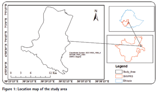
Hawassa town is the capital city of the Southern Nations, Nationalities, and Peoples’ Region, and is a capital city of Sidama Zone. Its geographical location is between 6055’30” to 7°5’15” and 38023’15” to 38°38’15”E with an elevation of 1708 meters above sea level. It is located 273 km South of Addis Ababa via Bishoftu, 130 km East of Soddo, and 75 km North of Dilla [15].
Research methods
Data collection
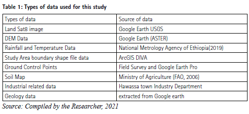
Both primary and secondary data were used for the industrial site mapping of the study area, which were obtained from field survey and concerned institutions. The data and materials used include satellite imagery Landsat8), climatic data (rainfall and temperature), Digital Elevation Model (DEM) 30 m resolution data, soil map and industrial data of the study area.
Data analysis methods for the study
Topographic factor (Slope)
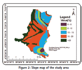
Slope map of the study area was generated from ASTER GLOBAL 30 meter resolution Digital Elevation Model. Then, the slope map was reclassified based on suitability of the slope for industry sites by using spatial analyst tools in Arc GIS. When the degree of slope becomes high, site suitability becomes less. The slope is classified in to five degrees as: 0 – 6%, 6 – 10%, 10 – 15%, and 15 – 20% and >20% and assigned new values as 5, 4, 3, 2, and 1 respectively [16]. Slope based industrial suitability level is described as Most suitable, suitable, moderately suitable, Less suitable and Unsuitable, respectively.
Proximity to water bodies
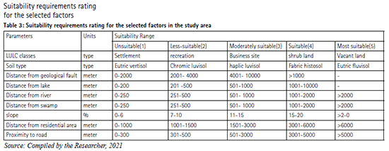
Proximity to lakes
Proximity to lakes map is generated and reclassified in Arc GIS by using ring buffer distance calculation in spatial analyst tools. New values were assigned for regions located within 0 – 200 meter, 201 – 500m, 501 – 1000 m, 1001 – 10000 m, and above 10,000m [16]. The study area reclassified as unsuitable, less suitable, moderately suitable and suitable. The reason why most suitable criterion rejected is about its range is out of the study area boundary.
Proximity to rivers
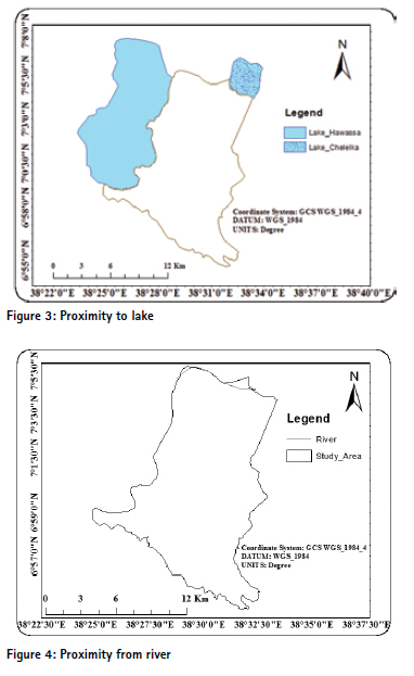
Traditionally, industrial land is located along rivers and canals because of its proximity to inexpensive hydropower [17]. Sites overlapping or adjacent to these areas pose greater insurance costs and risk potential flooding, requiring expensive flood mitigation strategies like barriers and retaining walls. Therefore, development within river zones is an unattractive characteristic and considered an industrial location constraint.
The river through Tikur Woha and Wosha River the way to Wondegenet was digitized from Google earth. The map showing proximity to rivers is generated by using ring buffer distance in spatial analyst tools of Arc Map from digitized rivers and canals. The reclassification of rivers map is based on suitability criteria. Areas found 0- 250 m, 250 – 500 m, 500 – 1000 m, 1000 – 2000 m and above 2000 m from rivers. The assigned new values as 1, 2, 3, 4 and 5 and classified as unsuitable, less suitable, moderately suitable, suitable and most suitable, respectively.
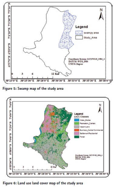
Proximity to swamps
As it mentioned above, swamps digitized from shapefile data obtained from [18] and the map generated in ArcMap 10.3.1 environment by using ring buffer distance calculation. The reclassification done based on industrial site selection criteria. New values were assigned for regions located within 0 – 200 meter, 200 – 500m, 500 – 1000 m, 1000 – 2000 m and above 2000m. The assigned new values were 1, 2, 3, 4 and 5.
Land use land cover factor
Land use situation with regard to different environmental effects and the condition of industrial establishment is very important. Forest and farming lands should not change to industrial land use and only a negligible damage to the plant cover can be allowed. Undersigned, in boundary, open space and free lands is preferable [19]. The reclassification was done because of industrial site selection criteria. New values were assigned for regions located within forest and water bodies are restricted it does not be represented with value whereas, settlements assigned as new value 1, recreation center as 2, business sites as 3, shrub lands as 4 and vacant land as 5. Then reclassified as unsuitable, less suitable, moderately suitable, suitable and most suitable, respectively.
Road network
Roads and other infrastructures that facilitate different cities and regions connection are very important in industrial site selection. According to the data obtained [16] industries needs transport facility and therefore its establishment should be near to the road. The reclassification was done based on industrial site selection criteria. New values were assigned for regions located within 300 meter as 5, 301 – 500 meter as 4, 501 m – 1000 meter as 3, 1001 – 5000 meter as 2 and above 5000 meter as 1.
Residential area factor
The reclassification was done because of industrial site selection criteria. New values were assigned for regions located within 1000 meter as 1, 1000 – 1500 meter as 2, 1500 m – 3000 meter as 3, 3000 – 6000 meter as 4 and above 6000 meter as 5. Then, the newly reclassified value represented as unsuitable, less suitable, moderately suitable, suitable and most suitable respectively.
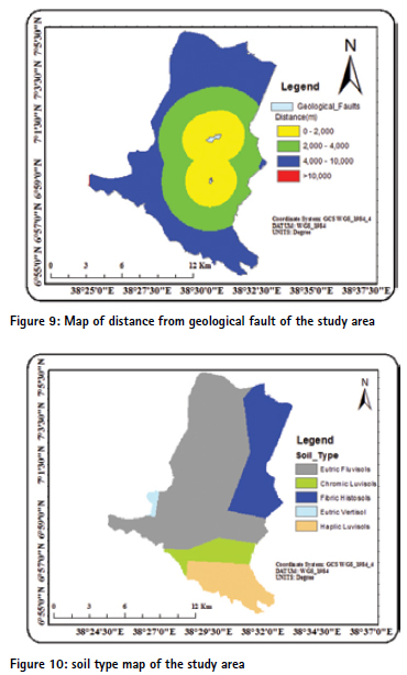
Geological fault factor
Hawassa town has a volcanic origin. It was formed due to intensive tectonic activity. This tectonic activity is a direct result of the Main Ethiopian Rift valley. The geology of the Awassa area consist of different volcanic deposits such as alkaline and peralkaline rocks Late Miocene, Basaltic lava flows from Pleistocene to recent, Acidic volcanics from Pleistocene to recent, and Volcano clastic lacustrine sediments from Pleistocene to recent [20].
Distance to geological fault is one of the hindering factors for industrial site selection. The more far away from this event is the better. The map of fault distribution was constructed from geological maps. The geological fault zones of the study area were digitized from Google Earth pro and converted to the shapefile data format in order to undertake further analysis. The reclassification was done on the basis of industrial site selection criteria. New values were assigned for regions located within 2,000 meter as 1, 2,001 – 4,000 meter as 2, 4001 m – 10,000 meter as 4, and above 10,000 meter as 5. Then, the newly reclassified value represented as unsuitable, less suitable, suitable and most suitable respectively.
Soil factor
According to [21], those soils with clay, alluvial and loam deposits are suitable for industrial establishment, whereas soils with cracking, swelling and porous are not suitable for industrial establishment. The reclassification was done based on industrial site selection criteria. New values were assigned for regions located within eutric vertisol as 1, chromic luvisol as 2, haplic luvisol as 3, and fabric histosol as 4 and eutric fluvisol as 5. Then, the newly reclassified value represented as unsuitable, less suitable, moderately suitable, suitable and most suitable respectively.
Interview and discussion
The primary data collection was accomplished by using an interview and discussion that is one of the important social research methodologies. The discussions were held with experts of manufacturing site evaluation and implementation core work process teams in identifying industrial site selection criteria and finding out the buffer distance that the site should be separated from relevant geographic features.
Direct and indirect unstructured interviews were conducted with the experts during the field survey to gather more information. The information derived from this study was used to identify and develop priority criteria and factors for the selection of industrial site. It was also used to identify problem in the study area and prioritize the potential industrial sites in the study area. Additional discussions made particularly with those experts, who are involved in the urban land preparation of Hawassa town, in order to acquire some appreciation of the study area. In particular, the following experts working at the town Industrial and Enterprise department, Housing and Urban Development Department and finally with Regional Bureau Industry experts discussion were held. Those who were involved in the discussion were interviewed: Mr Matusala Semaye, Yaregal Debebe, Sileshi Getahun and Walelign Awashe.
Multi-Criteria Decision Making (MCDM)
This research study was mainly used spatial Multi-Criteria Decision Making (MCDM) approach integrated with Geographic Information System (GIS) techniques in order to determine suitable site for industry. Spatial multi-criteria decisionmaking is a process that combines and transforms geographical data into a decision (Malczewski, 1999).
MCDM, combined with GIS data, is a powerful approach systematically and comprehensively analyze a problem. The fundamental components of a multi-criteria problem are human value judgment and assessments of the importance of criteria. The main purpose of the multi-criteria evaluation techniques is to investigate a number of alternatives in the light of multiple criteria and conflicting objectives (Voogd, 1983).
To combine and determine the importance of each factor, multi-criteria decision-making method was applied.
Analytic Hierarchy Process (AHP)
Analytic Hierarchy Process (AHP) is a widely used method in MCDM and introduced by [22]. It is easily implemented as one of the MCDM techniques. AHP is a decision support tool, which can be used to solve complex decision problems. It uses a multilevel hierarchical structure of objectives, criteria, sub criteria and alternatives. AHP uses a fundamental scale of absolute numbers to express individual preferences or judgment (Table 4). This scale consists of nine points. In general, nine objects are the most that an individual can simultaneously compare and consistently rank.
The score of differential scoring assumes that the row criterion is of equal or greater importance than the column criterion. The reciprocal values (1/3, 1/5, 1/7 have been used where the row criterion is less important than the column criterion. To ensure the credibility of the relative significance used, AHP also provides measures to determine inconsistency of judgments mathematically. Based on the properties of reciprocal matrices, the consistency ratio (CR) can be calculated. CR < 0.1 indicates that level of consistency in the pair wise comparison is acceptable. According to [22], if CR is smaller than 0.10, then the degree of consistency is acceptable. However, if it is larger than 0.10, then there are inconsistencies in the evaluation process, and AHP method may not yield meaningful results.
Results and discussions
The following factors deeply discussed in this part. These are Land use land cover types, distance from geological faults, distance from main roads, soil types, and distance from residential areas, distance from water bodies (lake, swamp and river/stream), slope and elevation.
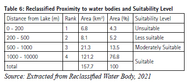
Relation of topography (slope) and industrial sites
In this study, slope factor generated from the Digital Elevation Model (DEM) using the ArcGIS 10.3.1 spatial analyst extension of surface module, which enabled to classify the area according to the steepness and the gentleness of the terrain. Every cell in the output raster had a slope value. The lower the slope value, the flatter the terrain was and the higher the slope value the steeper was the terrain. Then the slope raster was reclassified in to five classes of slope percent by examining the value and the frequency of slope percent in the study area. The reclassified slope was given a rank value 1 to 5 with the higher value of 5 showing high influence, i.e. highly suitable, while the lower value of 1 showing low influence, least suitable. According to [16], slope with degree ranges from 0-6 considered as level slope, 6-10 degree as gentle, 10 -15 degree as strong sloppy, 15- 20 degree as moderately steep slope and > 20 degree slope as considered as steep slope). As indicated in the figure 11 below, most of (68.6%) the study area has gentle slope and 3.2% has a moderately steep slope.
The less the slope amount, the more suitable will be the area for the industry. Based on the suitability of the slope for industrial sites, the reclassified slope map shows 108.2 km² (68.6 %) area is most suitable, 23 km² (14.6%) is suitable, 11.7 km² (7.4%) is moderately suitable, 5.1 km² (3.2%) is less suitable and 9.8 km² (6.2%) unsuitable for industrial location. From the total area of the study, majority of the slope initiates public and private investors to participate on industrial sectors in which Plain areas have especial importance because of lesser costs during site preparation.
Proximity to water bodies and industrial locations
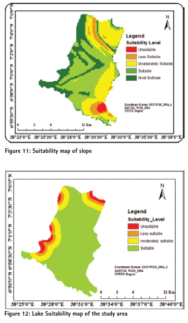
Proximity to lake
Water accessibility is one of the main affecting factors for industrial site selections. Industry must be located at some safe distance from water bodies. Water bodies and areas within 1000 meter are considered unsuitable for an industrial establishment. Wastewater from industry is one of the major sources of pollution in river distance of at least 1000m [23]. According to [16], land suitability for industrial location within proximity to lake as follows: The proximity to water bodies map is the result of overlaid proximity to Lake Hawassa and Chelelka maps. As indicated in the figure 12 below, 6.8 km2 of the total area is within 200 meter of the water bodies, 8.1km2 is found between 200 meter up to 500 meter, 21.3km2 is found between 500 meter up to 1000 meter, and the remaining 121.2km2 found beyond 10000 meter. This implies that most parts (76.8%) of the study area are suitable, 13.5% is moderately suitable, 5.2% is less suitable, and 4.3 % is unsuitable for industrial location.
Proximity to river
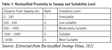
Both stream flow of the Wosha and Tikur Woha River, which found in North Eastern part of the study area were taken as the base line to measure the proximity. During rainy season, runoff would be high and that could disturb if there is industry near at those stream flow area. According to [24], land suitability for industrial location within proximity to river as follows: those areas up to 500 meter far from the river are unsuitable, 501 meter -1000 meter are less suitable, 1001 meter – 3000 meter are moderately suitable, 3001 meter up to 5000 meter are suitable and above 5000 meter are most suitable to establish industry.
As indicated in the figure (13) below, majority of the study area which is suitable to settle industry is 2000 meter far from the river. Those areas, which are within 1000 meter from the river, are not suitable for industrial location. The reclassified map of distance to rivers indicates that most suitable sites for industrial establishment cover 86.5 km² (54.8%). The remaining 27.7km² (17.5%) is suitable, 29.8 km² (18.9%) is moderately suitable, 5.9 km² (3.7%) is less suitable and 5.4 km² (3.3%) is unsuitable to locate industries in the study area.
Proximity to swamps
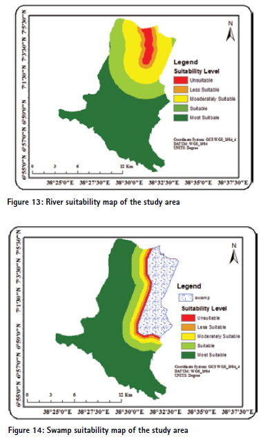
Cheleleka Swamp, which found on the way to Wendogenet gradually transformed in to a swamp around 1970, fed with around 11 perennial rivers emerging from the eastern highlands. A few decades ago, Lake Cheleleka was the second lake in the area located about five kilometers to the east of Hawassa. This lake was about 11 km long and 6 km wide, but disappeared decades ago [25], [26], [27] and [28]. The former Lake Cheleleka is now a swampy area. Swampy areas are not suitable to establish industry in a given area because they have a reputation for being unproductive land that cannot easily be utilized for human activities, other than perhaps hunting and trapping. According to [24], land suitability for industrial location within proximity to swamps as follows:
Based on the proximity to swamps, the majority of study area is most suitable for industrial location. As described in the figure 14 below, 94.5 km2 (60%) of the total area is most suitable and 34.7 km2 (22%) is unsuitable to locate industry in the study area.
Besides that, 3.7km2 (2.3%) less suitable, 7.7km2 (4.88%) is moderately suitable and 16.6km2 (10.5%) is suitable to locate industries in the study area.
Land use land cover maps
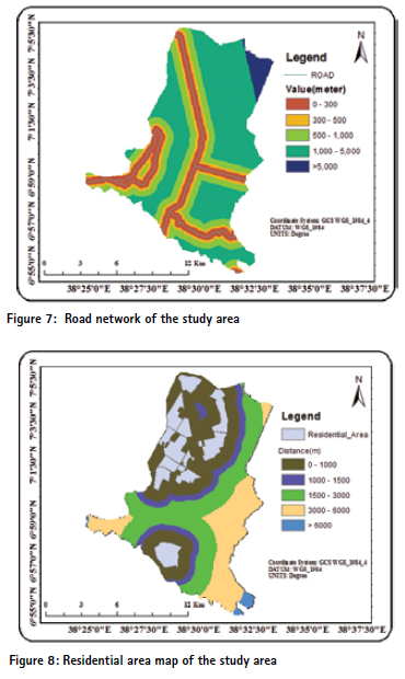
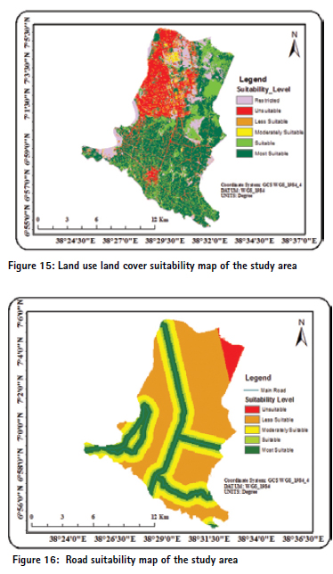
Land use classification is the process of categorizing the data based on their data file values. If pixels fulfill a certain set of criteria, then the pixel is assigned to the class that corresponds to that criterion. In this study, the existing land use map was extracted from LandSat8, 2021. Based on the supervised classification done for the satellite image, the study area has seven major land use land cover types, such as recreational center, shrub lands, water body, vacant land, forest coverage, commercial or business centers and residential. Mixed type of land use is dominant, especially residential development mixed with commercial and other activities that are common in the central parts of the study area. In general, the majority (65.7 km2) of land use land cover map of the study area was vacant land since newly desired master plan of the town incorporates the surroundings of Sidama zone and 32.2km2 of the total area is residential/settlements and 30.6 km2 of the total area is shrub lands and 17.7km2 is about forest coverage. On the other hand, water bodies, recreational centers and business activities covered a small portion of the study area.
According [24], water bodies, swamps, forest coverage and residential areas are not suitable for industrial establishment. Whereas areas like open spaces, vacant lands, range lands area suitable for industrial site location. From the total area, the reclassified map in the figure 15 below shows that 32.2 km2 (20.5%) is unsuitable, 30.5km2 (19.3%) leveled as less suitable, 3.52km2 (2.23%) is moderately suitable, 4km2 (2.5%) as suitable and 65.6km2 (41.6%) leveled as most suitable. From the total area, 22.05 km2 (13.98%) are forest and water bodies were assigned zero weights (restricted), hence these sites are not considered for industrial development.
Distance from the road and industrial location
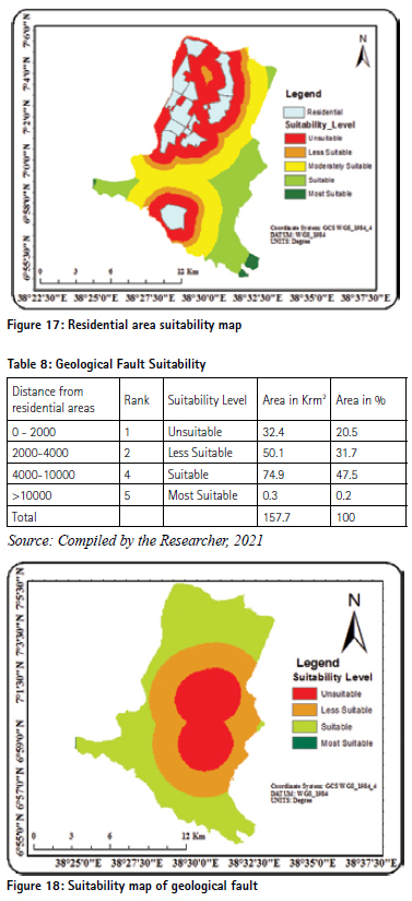
Road is also an important criterion in site suitability analysis. The need to transport raw materials, processed materials and other important things, carcasses, are dependent on the proximity to transportation facility. In order to find out better accessibility to the existing road, buffer zones have been created by taking distances from 0 to 300 meter from the existing major roads to generate suitable accessibility map. Then the buffer distance zones have been categorized into five levels based on the level of proximity to industry site. Accordingly, the low buffer distance ranked as highly suitable whereas the longer buffer distances ranked as least suitable. Thus, the rank value of 5 was given for highly suitable road buffers and the rank value 1 was given for unsuitable road buffers.
From the total area, about 26.6 km2 (16.8%) is most suitable for industrial sites and only 4.8km2 (3.04%) is unsuitable for the industrial establishment. About 76.4km2 (48.4%) of the study area is less suitable to settle industry, which is related transport accessibility. As newly proposed structural plan of the town stretched to the fringe of rural area, it requires road construction in the future.
Distance from the residential area and industrial location
A logical distance should be selected between residential areas and industrial sites. A buffer should be defined as well. These areas are barriers for industries development. The more distance from industrial areas the higher suitability and consistency will be. According to the data obtained from [16], an industry needs to be established far from the residential areas. These areas are barriers for industries development. The more distance from industrial areas, the higher suitability and consistency will be.
As indicated in the figure 17 below, from the total area 70.03km2 (44.4%) is unsuitable as the area occupied by the residents of the town and only 2.07km2 (1.4%) is most suitable for industrial site selection. In addition, 40.5km2 (25.7%) is moderately, 40.2km2 (19.3%) is suitable and 14.5km2 (9.2%) is less suitable for the site selection of the industry.
Distance from geological fault and industrial location
Geology considered as it plays an important in the suitability decision of sites for industries. Strength of the rock and absence of fault zones will make the site suitable at the first place. Without this consideration, it is difficult to go forward in the process of site selection at any cost. Seismology and faults are very important in the development planning. The fracture resulted from geological faults will affect neighborhood sediments and rocks. Regarding legal buffer from fault lines and avoiding industrial developments in such areas are considerable factors in the industrial site selection. Faults are one of the geological phenomena that cause problem for industrial buildings and infrastructure construction. Industries should be 2000 m away from faults. The area that are within 2000 meter are unsuitable, 2001 – 4000 meter are less suitable, 4001 – 10000 meter are suitable, and area >10000 meter are most suitable to establish industries [29].
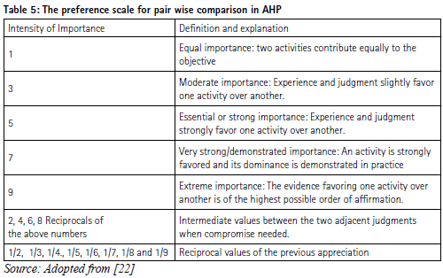
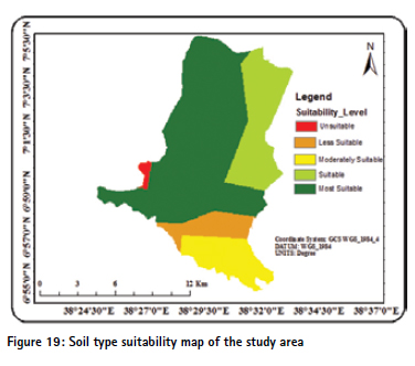
Soil type and industrial site selection
The soil has a significant impact on the amount of recharge, which can infiltrate into the groundwater and hence, influences the ability of contaminants to move vertically into the industry zone (Burden and Sims, 1999). In the figure (30) below, the extracted soil type of the study area were described. Those are eutric fluvisols, chromic luvisols, fibric histols, eutric vitricsol and haplic luvisols. According to Harmonized World Soil Database [30]:-
Fluvisols: These soils are young soils and rich in alluvial deposits.
Luvisols: Soils with subsurface accumulation, low activity clay, high basic saturation, are porous and crumb characteristics.
Vertisols: they are dark colored cracking and swelling clays.
Histols: Soils that composed of organic materials
According to [21] report, those soils with clay, alluvial and loam deposits are suitable for industrial establishment, whereas soils with cracking, swelling and porous are not suitable for industrial establishment.
As indicated in the table 19 below, from the total area 92.5km2 (58.7%) is most suitable and only 1.4km2 (0.9%) is unsuitable for industrial site selection as the area filled by the Eutric vertisol. Moreover, 18.2km2 (11.5%) is moderately, 31.6km2 (20.03%) is suitable and 11.8km2 (7.5%) is less suitable for the site selection for the industry. Figure (29), above portrays soil type suitability for the industrial site selection
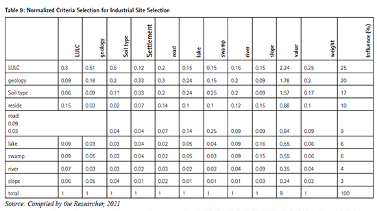
Calculation of the Weight Normalized
The normalization of criteria values allows for the direct comparison of criteria when calculating suitability and reflects the conceptual relationship between the criteria value and a suitability score [31], Priority vector called normalized Principal Eigen vector. To normalize the values, divided the cell value by its column total and calculated the priority vector or weight by determining the mean value of the rows [22]. In order to check whether the set criteria is correct or not, the researcher computed normalization.
As can be seen from the suitability map (Fig 20), about half (50.7%) of the study area is suitable for industrial location. The suitable areas are mainly located in the Southern, South Eastern, South Western and central part approaching to the corner of the town. These areas were mainly vacant, bare lands and away from water bodies. In the Eastern part of the study area, on the way to Wondogenet, the new structural plan incorporated vacant lands to the town which favors good condition for the industrial site selection; and areas are free from urban settlements; and are occupied by sparse vegetation. For this reason, those parts are suitable for industrial implantation.
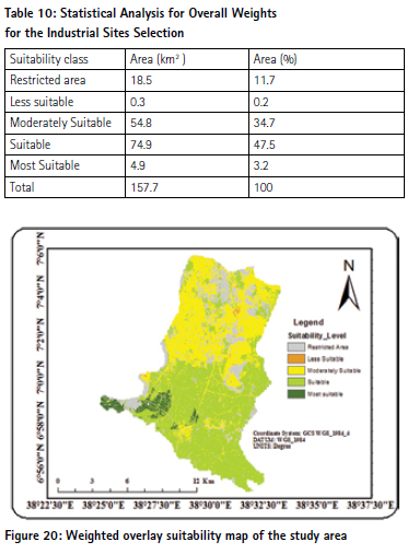
On the other hand, most parts of Huwella Tula subcity were moderately suitable for industrial sites. Even if the areas were sparsely populated and free from water bodies, because of optimum transport inaccessibility up to the fringe the sub-city; it was a little bit important for the industrial sites. And also, those areas with shrub trees and bare lands are suitable to plant industry for the future. Obviously, those parts in the stated sub-city, the existing weather roads were considered as hindrance for the transportation of raw materials. This would impose private investors not to invest on that transport inaccessible areas. So in this area, small proportions of the study area were leveled as moderately suitable.
Swamps, lakes, streams and forest coverage through Lake Hawassa up to Tikur Wuha area were considered as restricted. For this reason, the researcher masked out those areas and leveled as restricted parts. Therefore, about 11.7% of the total study areas were not permitted to suitability criterion on this study. In the study area, about 35% of the study areas were less suitable and moderately suitable for industrial site selection. This is because of, central parts were occupied by the recreational centers, settlements and built up areas, business sites and around Hayk Dar areas were considered to be constraints for industrial establishment.
Concluding remarks
GIS and Remote Sensing as analysis tools are valuable tools that can support the decision makers to find best possible industrial sites. The GIS analysis requires collecting data from different sources with different formats to create a complete uniform database. Thus, the GIS data should be updated regularly in order to reflect the current situation of an area under investigation. Remote sensing data can assist to have updated information of the study area.
The analysis has taken land use/cover, slope, surface water, proximity to main roads and streams/river, swamps, distance from residential areas, distance from geological faults and soil types. From those parameters, land use land cover, geological faults and soil types were highly determining the selection of industrial sites in the study area. Since the study area is relatively flat slope, elevation and slope parameters play small portion in determining site selection. After weight over lay computed, about 50% of the study area is suitable for industrial location and only 0.2 % is less suitable to locate industry.
In the study area, the town Urban Development and Housing Department utilizes AutoCAD highly to administer land. However, there is shortage of experts who are GIS and Remote Sensing backgrounds. This resulted in ignorance of appreciating those best technologies like GIS and Remote Sensing.
The GIS based multi criteria evaluation technique is simple and flexible which can be used to analyze the potential sites for urban development and encourage public participation in the urban decision making process. Thus, planners and authorities in order to formulate suitable plan for sustained development of the town, they have to undertake the application of GIS and Remote Sensing technologies. In the study area, industries were accumulated in the central and main parts of the town. This may result in different social and economic problems (interruption) on the residents. Therefore, the town administration has focus in order to plant industries far away from residential and other economic areas of the town. The study area selects industrial sites if there was a vacant land. Existence of a vacant land itself is not enough to establish industry. Those listed factors in this study and additional parameters have to be taken in to account for further industrial development. The town Industry and Enterprise, Housing and Urban Development, Forest and Environmental Protection Departments have to provide short term and long term GIS and remote sensing training for the experts.
References
[1] Aleksander Rikalovic, Dordo Cosic, Srdan Popov and Dorde Lazarevic. 2013. Spatial Multi-Criteria Decision Analysis for Industrial Site Selection: The state of the art, XI Balkan Conference on Operational Research-Balcor, Belgrade
[2] Manish and Vivekanda. 2013. Identification of Potential Sites for Urban Development Using GIS Based Multi Criteria Evaluation Technique. A Case Study of Shimla Municipal Area, Shimla District, Himachal Pradesh, India
[3] Zahra, Aarushi Singh, Sanjay Kumar and Malik. 2014. Major MCDM Techniques and their application-A Review M. Tech. Student, Hindu College of Engineering, Sonepat Dept of CSE, Hindu College of Engineering
[4] Eldin and Sui. 2013. A COM-Based Spatial Decision Support System for Industrial Site Selection, Geography Department Texas A&M University College Station, TX 77843, USA
[5] Thanuja, Leo. P, Pichaya.R, and Mohamed. 2015. Suitable Site Selection for Establishing SWM Centers by Considering All Environmental, Social and Economic Criteria
[6] Fernando Garcia-Menendez, F., E. Monier, and N. E. Selin. 2015. The Role of Natural Variability in Projections of Climate Change Impacts on U.S. Ozone Pollution, Geophysical Research Letters, 44, Doi:10.1002/2016GL071565
[7] Rizaludin Mahumud. 2015. Multiple- Criteria Analysis to Perform the Tasks of Site Selection. Study and Analysis of Chennai Flood 2015 Using GIS and Multi-Criteria Technique, Civil Engineering, Excel Engineering College, Namakkal, India
[8] Aleksander Rikalovic, Dordo Cosic, Srdan Popov and Dorde Lazarevic. 2013. Spatial Multi-Criteria Decision Analysis for Industrial Site Selection: The state of the art, XI Balkan Conference on Operational Research-Balcor, Belgrade
[9] Masood A. Badri. 2007. Dimensions of Industrial Location Factors: Review and Exploration, Journal of Business and public affairs Volume 1, Issue 2
[10] Florida, R. 2002. The Rise of the Creative Class, the Washington Monthly, pp. 15-25.
[11] Bhatnagar, R and Sohal, S. 2005. Supply Chain Competitiveness: Measuring the Impact of Location Factors, Uncertainty and Manufacturing Practices, Technovation, 25(5), pp. 4434.
[12] Kotler, P.J., Haider, D.H., Rein, I. 1993. Marketing places: Attracting investment, industry and tourism to cities, states and nations, New York, itd: Free Press
[13] Reisi, L. Aye, A. 2011. Industrial site selection by GIS in Isfahan, 19th Iran International Conference on Geo-informatics
[14] Aleksandar Rikalovic, Ilija Cosic, Ruggero Donida Labati, Vincenzo Piuri. 2016. A Comprehensive Method for Industrial Site Selection: The Macro-Location Analysis
[15] Hawassa Town Finance and Economic Development Department. (2015). Socio-Economic Profile of Hawassa Town, Published, Hawassa, Ethiopia
[16] Ebrahim Fataei, Mehdi Aalipour erdi, Habib Farhadi and Ali Mohammadian. (2015). Industrial State Site Selection Using MCDM Method and GIS in Germi, Ardabil, Iran Journal of Industrial and Intelligent Information Vol. 3, No. 4, December
[17] Mark Berube. 2014. GIS Multi-criteria Evaluation for Identifying Priority Industrial Land in Five Connecticut Cities, Master of Regional Planning University of Massachusetts
[18] FAO. 2006. World reference base for soil resources. A framework for international classification, correlation and communication, Rome: Italy
[19] Eldin, K. Eldrandaly, M. Shouman and G. Na wara4. 2013. An Industrial Site Selection system Use of COM in Integrating an Intelligent GISAHP Application. The International Arab Journal of Information Technology, Vol. 10, No. 3
[20] Alemayehu Abiye, T. 2008. Environmental resources and recent impacts in the Awassa collapsed caldera, Main Ethiopian Rift. Quaternary International, 189, 152-162.
[21] Anurag Ohri, Prabhat Kumar Sing and Priyanka Kumari Singh. 2010. Spatial Multi Criteria Analysis for Siting Industries, Banaras Hindu University, Varanasi
[22] Saaty, T.L. 1980. A scaling method for priorities in hierarchical structures: Journal of Mathematical Psychology, Vol, 15, No, 3,Pp. 234 – 281
[23] John Wiley and Son. 1994. A GISBased Approach to Mapping Probabilities of River Bank Erosion: Regulated River Tummel, Scotland
[24] Amita Johar. 2013. Land suitability analysis for industrial development using GIS, Indian Institute of Technology Roorkee
[25] Ayenew, Tassew. 2004. Environmental implications of changes in the levels of lakes in the Ethiopian Rift since 1970. Regional Environmental Change, 4, 192-204
[26] Grim Haw D J. 1996. Bringing Geographical Information Systems into Business (2nd edition). Cambridge, Geo-information International
[27] Ayele Abebe. 2017. Land Use and Land Cover Change Detection Analysis using Remote Sensing Techniques : The Case of Hawassa Town, Southern Ethiopia
[28] Dessie, G. And Kleman, J. 2007. Pattern and Magnitude of Deforestation in the South Central Rift Valley Region of Ethiopia. Mountain Research and Development, 27, 162–168.
[29] Marzieh Reisi1, Lu Aye1 and Alireza Soffianian. 2011. Industrial Site Selection by GIS in Isfahan, Iran, Department of Natural Resources, Isfahan University of Technology
[30] Yemane Gebreziabher. 2004. Assessment of Water Balance at Lake Hawassa Catchment Area, International Institute for Geo-Information Science and Earth Observation, Enschede, Netherland, published.
[31] Eastman, J.R., P.A.K. Kyem., J. Toledano, and Willian. 1993. GIS and Decision Making, Vol. 4, Explorations in Geographic Information System Technology, UNITAR, Geneva.
The paper is first published in American Journal of Remote Sensing. Vol. 10, No. 1, 2022, pp. 1-14. doi: 10.11648/j. ajrs.20221001.11 is republished with authors’ permission.
The authors’ publications in SciencePG are distributed under Creative Commons Attribution (CC BY) license (http:// creativecommons.org/licenses/by/4.0/). The license was developed to facilitate open access, namely, free immediate access to and unrestricted reuse of original works of all types.


 (No Ratings Yet)


Leave your response!