Articles tagged with: MUNEENDRA KUMAR

The Mix up of “X, Y, Z” Coordinates Between Photogrammetry and Geodesy
In Spatial considerations –
In geodesy, the “ZXY” coordinate system is “right-handed”, where the right thumb points towards the Z-axis, index finger towards the intersection of the Reference Meridian and Equatorial planes, and middle ?nger or the positive Y-axes, which is …

1. Spheroid is considered equivalent to an ellipsoid.
2. The longitude at the North or South Pole is zero degree.
3. The Mean Sea Level (MSL), a time-variant “average”, is
considered as time-invariant and time-independent.
4. The measured “dn” along a spirit level loop sum up to zero.
5. Imagine a freely ?owing ocean or sea channel under
a continent and it represents the Geoid.
6. The geoidal undulation or height (N) is equivalent to orthometric height (H).
7. There are “yours” and “mine” geoids. In other words every country has its
own geoid, creating a “political” boundary value problem for gravity.
8. When one has to re-observe at any station, it does not make any
difference so long one is observing within “few” meters.
9. If one asks for and gets a height as “123.4 m”. It is OK to add
zeros at the end, e.g., 123.4000, to make it more accurate.

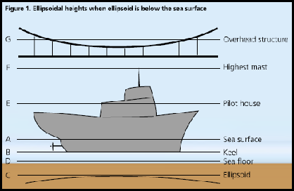
For safe sailing, two most important requirements are to be able to determine clearances between the sea floor and the keel of the ship, and between the mainmast and overhead structures, such as cables and bridges. For these clearances, the mariner has to know correctly and accurately the following:1. Location of the sea floor or ocean depth,2. Height of the overhead structure,3. Locations of the ship’s keel and mainmast.

The International Terrestrial Reference Frame (ITRF) “yy” is a realization of the International Terrestrial Reference System (ITRS), where the “yy” represents the year of the solutions. Since its fi rst realization in 1988, there have been many variations and additions in use of data types and changes in computational strategy.
International Earth …

Under the new Map Policy, it seems that India has decided to retain the old Indian Datum, which has been identified by “Everest”, for DSMs. The following geodetic definition issues and “specifi cations” are worth commenting:
Vintage – 1880s.
Name – On a recent enquiry, four SOI experts provided four different names. However, it cannot be “Everest”.
Spheroid …


 (5.00 out of 5)