Articles tagged with: KAI-WEI CHIANG

Global Positioning System (GPS) provides precise timing, position, and velocity information by utilizing the constellation of satellites and a remote receiver that uses range measurements to the satellites and spatial trilateration techniques. In addition, more navigation satellite systems including Russia’s GLONASS, Europe’s Galileo, and PRC’s Compass will be available for the coming years. Those systems will form the mainframe of future Global Navigation Satellite System…

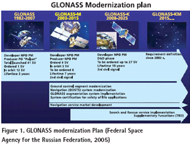
THE conventional geomatics industry including mapping and surveying applications has been revolutionized with the use of GPS, which is the best known, and currently fully operational satellite based navigation system operated by USA (Parkinson, and Spilker Jr., 1995). In the mean time, Russia also operates its own satellite based navigation system called GLONASS. The USA is modernizing GPS in order to retain its superiority in satellite based navigation technologies (MacDonald, 2002,). In order to keep up with USA’s progress in building next generation system, Russia is taking serious steps to modernize GLONASS as well (Federal Space Agency for the Russian Federation, 2005). The GPS and GLONASS signals are free but its availability is not guaranteed and currently most users are prepared to accept this risk (Parkinson, and Spilker Jr., 1995). However, as satellite navigation becomes a vital technology across a number of critical industrial sectors, the prospect of, for example, a nation’s transport infrastructure becoming dependent on this technology is a strategic risk that most industrial countries are not willing to accept. This argument initiated the Galileo program in Europe. Therefore, those systems form the mainframe of Global Navigation Satellite Systems (GNSS) (MacDonald, 2002,).

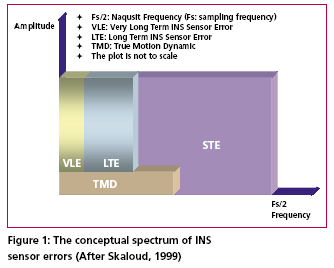
According to Skaloud [1999], the inertial sensor errors are composed of long term errors (low frequency components) and short term errors (high frequency components). Therefore, a conceptual plot of the frequency spectrum of the inertial sensor errors in the measurements can be illustrated as in Figure (1).


 (5.00 out of 5)