
Forest Survey of India says forest cover estimate is done with field data tallied with Satellitebased Interpretation
Amid criticism from experts of its methodology to map forest cover in the country, the Forest Survey of India (FSI) has said that the forest cover is estimated from the field inventory data, which corroborate the figures obtained from …
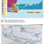
The aim of this research is to produce a new and updated map Lagos Island Local Government Area, Nigeria and document changes that have occurred over time
Leonard Michael Onyinyechi Aminigbo
Department of Geography and Environmental Management, Rivers State University, Portharcourt, Nigeria
Abstract
The scope of the research work comprised the planning and preliminary data requirement analyses, acquisition of …

The results of the study conducted in Perth, Australia show distinct advantages of using spatial statistics at the site investigation scale, and for measuring multiple elements not just potential contaminants
Andrew W. Rate
School of Agriculture and Environment, The University of Western Australia, Australia
Abstract
Public recreation areas in cities may be constructed on land which has been contaminated …

The expected results will be a contribution to the assessment of natural risk and seismic hazard in the study area and will have a positive impact for the sustainable development of the region
Nikolay Dimitrov
Assoc Professor, Head of Department Geodesy, National Institute of Geophysics, Geodesy and Geography, Bulgarian Academy of Science, Bulgaria
Introduction
The study of recent crustal …
Pixxel launches first commercial satellite
Pixxel, the Indian Space-tech startup has launched its first commercial satellite, TD- 2. It is a full-fledged commercial satellite that hosts one of the highest resolution hyperspectral commercial cameras to be ever flown. It has been launched with SpaceX’s Falcon-9 rocket, in order to build a 24×7 health monitor for …

First high-orbit GLONASS satellite in 2028
Russia plans to launch the first of the six high-orbit GLONASS satellites into orbit in 2028, according to the head of the GLONASS Application Division in the Russian space agency Roscosmos, Ivan Revnivykh. Such satellites will be able to transmit two navigational signals with code division in the L1 …

No, India’s forest cover has not increased steadily. Instead, tea estates, coconut plantations, and even tree-lined avenues are being classified as forests
M D Madhusudan
Ecologist
T R Shankar Raman
Ecologist
It is not long after dawn, but the air in the Borajan rainforest in upper Assam is already warm and heavy with humidity. On a fig tree by the …

Readers may recall that we have published the first part of this paper in April 2022 issue of Coordinates where material and methods were discussed. Here we present the concluding part
MD Abdul Mueed Choudhury
Department of Agricultural, Food, and Environmental Sciences, Marche Polytechnic University, 60131 Ancona, Italy
Ernesto Marcheggiani
Department of Agricultural, Food, and Environmental Sciences, Marche Polytechnic …

This paper evaluated a real-time KSACORS-based NRTK GNSS-INS integrated solution and a post-processed KSACORS-based NPPK GNSS-INS integrated solution
Mohammed El-Diasty
PhD, P. Eng. Civil and Architectural Engineering Department, College of Engineering, Sultan Qaboos University, Muscat, Oman
Abstract
Multibeam echosounding technique is used to provide sea-floor mapping with relatively high-quality level and requires an accurate positioning and attitude system. Integration …


 (5.00 out of 5)