
July 2009
Bentley Be Connected Online Seminars
23 July-30 Nov.
www.bentley.com/BeConnected
Study GIS at Hong Kong Polytechnic
The Department of Land Surveying and Geo-Informatics at the Hong Kong Polytechnic University is now accepting applications for Master of Science/ Postgraduate Diploma in Geomatics (GIS/ Surveying). It is the longest running postgraduate program in GIS and the only one in Geomatics (Surveying) in Hong Kong. www.lsgi.polyu.edu.hk

Safe Navigation in Korea
In Korea, the Ministry of Land, Transport and Maritime Affairs shall soon provide small ships off the coast of the Korean peninsula with differential GPS information through mobile phones and other personal devices. Until now small avoided using professional equipment because of the price of the hardware. http://english.mltm.go.kr
Almost 20 years ago, as a Surveyor in private practice, and as someone who had a passing interest in politics, I presented a paper at a surveying conference, titled “Surveying the Political Landscape. At the time I had no ambition to stand for political office as I was more than fully occupied with my Surveying and Mapping business which was busy adopting new technologies such as Geographic Information Systems and Global Positioning Systems…
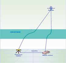
Global Positioning System (GPS) is currently one of the most popular global satellite positioning systems due to global availability of signal and performance. GPS employs two carrier frequencies which is L1 and L2 allowing receivers equipped with dual frequency operation to be used. Due to the inhomogeneity of the propagation medium in the ionosphere, the GPS signal does not travel along a perfectly straight line [1,2]…
Report on 3rd Land Administration Forum 24-26 May 2009-Tehran, Iran
The UN sponsored Permanent …

How can we plan and decide upon urban growth?, which house to buy as a secure investment?, which properties are at risk? All these are critical questions we have to face in a changing world and that may affect permanently our lives. For this reason, today it is much more important to make the correct decisions, whether for designing the national economy or making personal plans for the future.
Making decisions requires knowledge,…

GPS/INS integrated navigation system has been a candidate of integrity monitoring system since an inertial sensor could improve performance of the fault detection and exclusion (FDE) functions. Japan Aerospace Exploration Agency (JAXA) has developed several GPS/ INS systems called GAIA (GPS Aided Inertial navigation Avionics) for over ten years and succeeded in automatic landing of unmanned experimental…
Norway joins Galileo project
The Norwegian government will give a boost by providing 68.9 million euros (92.5 million dollars) towards the 3.4 billion euro project. While Norway is not a member of the 27-member bloc, the
country’s economy and business minister Sylvia Brustad said it was important that Oslo took part in Galileo’s development. “The project will be of huge importance for the development of the European space industry and it is therefore important that Norwegian businesses are now able to compete,” Brustad said in a statement. In September, the European Commission and the European Space Agency, which includes Norway as a member, shortlisted 11 European firms which are bidding for future contracts connected to Galileo. www.newsabout- space.org/story/157986254.html
Yaogan 6 launched
China Aerospace Science and Technology Corporation have recently launched the Yaogan 6 remote sensing satellite. It will mainly be used for land resources survey, environmental surveillance and protection, urban planning, crop yield estimates, disaster prevention and reduction, and space science experiments. Xinhua Agency


 (5.00 out of 5)