
Ordnance Survey to help Guyana reap the benefit of geospatial data
Ordnance Survey (OS) is to provide consultancy services to the Guyana Lands and Surveys Commission (GLSC) to re-establish and further develop the GPS Continuously Operating Reference Stations (CORS) network in Guyana. The project seeks to establish and sustainably maintain a modern, robust and accurate …
Virtual Surveyor streamlines workflow
The Virtual Surveyor drone surveying software now offers a faster, more efficient workflow and better overall user experience in a more stable platform. These new capabilities, along with an improved licensing system and an extended free application, are available now in Virtual Surveyor 6.
The software leverages the expertise and interpretation …
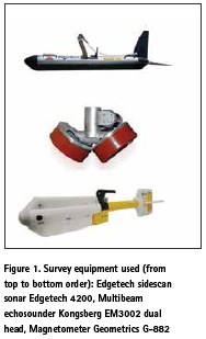
The purpose of this paper is to conduct the evaluation of the object detection using sonar and geophysical methods. Increasing interest in maritime archaeology has led to a growing need for measuring techniques or innovative methods..

Paddy is the third largest crop planted in Malaysia after oil palm and rubber. According to Paddy Statistics of Malaysia 2014 reported by Malaysian Department of Agriculture, nearly 679 239 hectares of land planted with paddy in Malaysia.

The existing geo-tectonic map of Japan has been produced by geological survey, rock classification, historical geological processes, faults etc. by expert geologists, geo-scientists, geographers and others. However, each geo-tectonic map may differ…
August 2018
5th International Conference on Geological and Environmental Sustainability
13-14 August Bali, Indonesia
…
Oscilloquartz launches enhanced PRTC solution for 5G network timing
Oscilloquartz, an ADVA company, has launched its enhanced primary reference time clock (ePRTC) system to enable unprecedented timing accuracy and stability even when the GNSS signal is lost. The technology provides the ideal timing source for missioncritical transport systems, such as utility networks; government infrastructure and …

When humanity triumphs
In Thailand, when thirteen members of Wild Boars football team
Were trapped in the cave,
They refused to cave in.
Demonstrated exemplary level of guts and grit
Their battle for survival
United the world.
The mission that looked impossible
Was made possible
By the human …
EU-wide rules for safety of drones approved
MEPs approved an agreement reached between Council and Parliament negotiators in November 2017 on EU-wide principles for drones and drone operators to ensure a common level of safety and give operators and manufacturers the predictability to develop products and services. Currently most drones fall under differing national rules, …
Airbus to provide an end-to-end Geo-Information system to Thailand
The Geo-Informatics and Space Technology Development Agency of Thailand (GISTDA) has selected Airbus as partner for its next-generation national geo-information system. The end-to-end system will make Thailand one of the few nations able to fully exploit geo-information for societal benefits. Fully in line with Thailand’s 4.0 …


 (5.00 out of 5)