The Union Minister of Civil Aviation Shri P. Ashok Gajapathi Raju and the Minister for State for Civil Aviation Shri Jayant Sinha presented and briefed the media about the draft regulation….

GNSS signals are very weak when received on the surface of the Earth and that makes them susceptible to a particular set of vulnerabilities – for example, Radio Frequency Interference (RFI), signal spoofing and atmospheric events…
Drones enter the sky safely through new technology
Two companies from the Netherlands and Belgium joined forces to show that drones can be managed and controlled using a specially developed small transponder combined with Unmanned Traffi c Management software. The new technology was developed by Unifl y supplier of transponders that make the drones visible. …
China plans space-based, solarpowered telecom drones: Report
A research institute affiliated with China Aerospace Science and Industry Corp is developing the project “Feiyun,” which means “flying cloud,” the Global Times reported, citing another report in the Science and Technology Daily. The network will be based in “near space”, it said, adding the system will be …
Former ISRO chairman UR Rao dies
Eminent space scientist and former Indian Space Research Organisation (ISRO) chairman Udupi Ramachandra Rao passed away. He was 85.
He was suffering from age related ailments and breathed his last at his residence in the city. Rao is survived by his wife, a son and a daughter, ISRO officials …

26 – 28 September, Berlin, Germany
INTERGEO is a meeting point for experts and decision-makers from the worlds of politics, science and industry on an international stage in Germany’s vibrant capital.
Use the trade fair and conference to experience and discuss GEO IT’s constantly evolving applications and future trends. Entirely in keeping with its long-standing motto “Knowledge and …

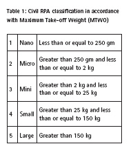
UAVs/drones can be simply defined as robotics planes. It is also known as Unmanned Aerial Vehicles (UAV), unmanned aircraft systems (UAS) and remotely piloted aircraft (RPAs) Ivosevic et.al. (2015). Malaysia Department of Civil Aviation (2008)…
Air Force says goodbye to 25-yearold GPS satellite
At 25-years old, GPS Vehicle Number 27 completed its time in orbit before the 2nd Space Operations Squadron said goodbye via final command and disposal on April 18. SVN 27 was launched in 1992, meaning it performed more than triple its design life of 7.5 years. Since …

Information has generally been one of the most precious goods in recent decades. It is possible to buy and sell it, to barter it or just only freely provide it. The value of the information itself is very often based on the fact that it is…


 (5.00 out of 5)