Articles in the Mycoordinates Category
Delhi itself gives the glimpse of the status of cities of India.
The stress of increasing population, lack of …

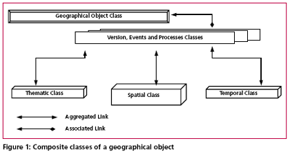
Despite the rapid advances in software and hardware technologies, the development of temporal databases capable of dealing with the evolution of geographical entities remains a challenging task. The aim of this paper is to discuss a proposed model that is able to handle spatial entities over time as a continuum.
The clout of Indian bureaucracy is demonstrated, again.
On July 20, the Union Cabinet of India approves …

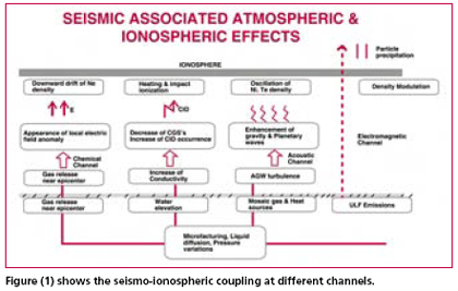
Early warning of earthquakes has actually become the main goal of seismology. And though seismic prediction started as a purely seismological discipline, it now involves hydrology, hydro -geochemistry, measurement of telluric and magnetic fields etc. The parameters under observations for the purpose of diagnosing seismic regimes include hydro -chemical parameters, atmospheric electrical disturbances, electromagnetic emissions, anomalous disturbances in the ionosphere and the magnetosphere recorded by satellite.

IRNSS to be independent of other constellations
The Indian Space Research Organisation (ISRO) will be establishing a satellite navigation system on the lines of the US GPS. The proposed Indian Regional Navigation Satellite System (IRNSS), which will consist of a constellation of eight satellites, is likely to be operational in six years time.
The Union Cabinet had approved the Rs 1,600 crore project in May this year. According to Madhavan Nair, Chairman ISRO the IRNSS would be developed indigenously and will be independent of other constellations.
India, a happening place.
Right to information, New Map Policy, and now a government resolution on NSDI.
A visible change in …
David Sharp was left to die.
Many saw him.
They didn’t do anything.
Perhaps they could not.
Perhaps it was ‘impossible’ to do …

Indonesian military plane to map quake-hit areas
The Indonesian Defence Forces (TNI) have assigned a CN-235 airplane to carry out aerial photography on areas in the Yogyakarta region affected by 27 May 5.9-magnitude earthquake. The activity is aimed at making a detailed map of areas devastated by the quake.
TNI had also sent a Hercules C-130 plane carrying a TNI field medical team and three helicopters to evacuate victims. http://news.xinhuanet.com
Conquering a technology is always important.
Owning it adds an arsenal to the might of the nation.
Hence, there is a …

Limestone constitutes the predominant raw material for manufacturing clinker, which in turn is an intermediate product to produce cement. But if the deposit is not homogenous and the coeffi cient of variation (COV) of the main inherent radicals in limestone is very high then the consistency in the quality parameters of the product varies and so on the process requirements thereby affecting productivity. In such cases the deposit has to be understood statistically and a proper geological model should be designed to best fi t our mine design parameters. This paper deals in detail how surpac leads in solving a similar problem…


 (5.00 out of 5)