Articles in the Mycoordinates Category

The soaring food price in recent months has been unprecedented.
Increased food prices could lead to increased poverty and unrest.
Even, UN call …
It is a demonstration once again.
Rather, an assertion of capabilities and underlying pride.
ISRO’s Polar Satellite Launch Vehicle,
PSLV-C9, successfully launched ten satellites
together, perhaps the highest payload ever.
…

Predictions and surveys indicate a boom in LBS.
All across the world.
Maybe at different pace at different places.
And, might be in different stages.
…

Many intelligent people into IT jobs in India are below their intellectual capabilities…
They are like coolies who are working for wages …

Navigational regionalism
Global Navigational Systems could have served the globe.
However, regions have specific needs.
Moreover, aspirations.
Aspirations to own and control the technology.
Owning makes sense as it adds to the might.
The desire and importance of ‘being mighty’ cannot be undermined.
So the pace for regionalism in navigation system may increase.
Still, they may work in cooperation. Hopefully.
…

RECENTadvances in information and communication technology (ICT)
have resulted in a changing environment with many interdependencies between organizations. There are various data services produced and consumed within the process of enhancement of pipelines project. This happens along the various phases; feasibility study, land allocation, execution and operation. Problems in data sharing arise from the fact that data services are not properly documented resulting in difficulties in updating data, data duplication and long administrative inter–organisational procedures[1]. This article presents a method for elaborating the trade-off between existing situation and the desired future in case of improving conditional data sharing.

This mega thrust earthquake of Dec 26, 2004 shifted several sites on Indian and Eurasian plates, which has been quantified from various GPS studies. As the relative change in triangular area between different sites is more sensitive than the relative change in their coordinates, it has been attempted to calculate the anomalies in triangular area on daily basis between 12 permanent GPS stations of C-MMACS and 16 IGS stations for a period of 60 days from 1st Dec 2004 – 30th Jan 2005.

Europe is building its own global satellite navigation system, Galileo, which will offer very accurate positioning and timing, under civilian responsibility. This system will be compatible with the two other existing systems, GPS and GLONASS. A user will be able to use the same receiver to calculate his position from signals sent out by any satellites combination, however Galileo will offer to all users a bi frequency system that will allow knowing position within one meter of accuracy, which is unprecedented for an openly accessible service. Apart from extreme circumstances, it will always be available and its users will be informed in a few seconds of a potential disruption of one of the satellites. Thus it will be usable for safety of life applications, requiring the highest security level, such as plane landing, train circulation or car guidance.
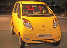
Nano effects
A historic moment.
For the automobile industry and for India too.
Tata unveiled small car Nano with a price tag of US$ 2,500.
When this ‘car for masses’ was promised, many did not believe.
Now it is a reality.
A revolutionary innovation.
An innovation that may change the life of millions.
GNSS technology too has this potential.
For imaginative applications and wider …

The LBS stream
It’s integral to the day-to-day functioning in the developed world.
In Asia, Japan and Korea lead the way.
The undercurrents are becoming visible in India.
First, it was the state-owned BSNL to join the LBS bandwagon.
Later, the private player Bharti Airtel followed suit.
Market dynamics indicate positive trends for LBS.
With the mobile phones holding the pulse of …


 (5.00 out of 5)