| Mycoordinates | |
SEISIMPACT System
|
|||||||||||||||||||||||||||||||||||||||||||||
|
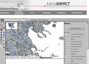
Greece has suffered many times from big earthquakes that caused human victims as well as big damage to public and private infrastructure. However, the 1978 earthquake in Thessaloniki (Mw = 6.5) motivated the beginning of a more systematic confrontation of the impact of such phenomena. This happened because it was the first time that a powerful earthquake affected a big modern city of roughly one million of residents. Thessaloniki presented the formal characteristics of Greek urban built environment: buildings with 4 to 8 storeys, large population in numbers and density, mixed land use, traffic problems and lack of effective planning of management of natural catastrophes. After the Thessaloniki earthquake, a situation of chaos was created due to the panic, the destructions, the lack of information and the innumerable calls on help, but also on control of static condition and damage of buildings. By that time, there was no specific procedure for the inspection of buildings and infrastructure. However, after the first period of embarrassment, the state agencies reacted. Inspection forms were designed, printed and distributed during the first days after the earthquake. The buildings were inspected by two-member teams of civil engineers in order to be classified in categories with regard to their damage and usability. These paper inspection forms constitute a valuable database concerning the impact of the earthquake to the buildings of Thessaloniki. Natural or anthropogenic disasters may have similar impact to the buildings and technical infrastructure of urban space. In particular, earthquakes are mostly considered as one of the most destructive natural hazards known to man with evident impact on urban infrastructure and human fatalities (Savvaidis et al., 2005). The objective of Civil Defence is to enable the responsible authorities to swiftly and efficiently meet the resultant demands and implement short-term emergency powers and long-term relief measures. Different GIS techniques and systems have been used for the recording and management of structural damage information on buildings. The most effective tools have been designed as network applications (SNDR report 2002, Savvaidis et al. 2005). The rapid development of the Internet has forced the world of Information Technologies in the creation of specialized software for such an environment, as well as new technologies in hardware. Web-based GIS is a Geographical Information System providing many capabilities for management and analysis of geographic data using technologies through the Internet. GIS has been adopted for all phases of emergency management: planning, mitigation, preparedness, and recovery. These phases are interrelated and output from one phase is often input for another. Planning involves identifying the hazards, risks, and possible consequences of an emergency. Only after the potential damage of an event is evaluated, can mitigation and preparedness activities start. GIS helps for the evaluation of the response action plans, as well. Finally, short and long term recovery can be better organized through GIS technology limiting the loss of life and property. With the exploitation of GIS tools, all important information can be recorded and analysed in geographical space, thus assisting the improvement of procedures and decision making. By giving civil protection authorities the tools for integrating data from many sources and analyzing how an event will affect an area, GIS has revolutionized the way governments and other agencies manage emergencies. The development of wireless technologies and Web-based GIS applications have also been recognized as the most effective way of allowing large numbers of users to interact with maps and GIS produced output enhancing the coordination of response efforts. The SEISIMPACT systemOn the basis of the above discussion, a Web-based GIS System was developed in the framework of the SEISIMPACT project for the organization into digital form and the evaluation of the records of reported damage in buildings connected to the occurrence of several types of disasters. For a pilot application of the system, inspection forms of roughly 50,000 buildings after the 1978 Thessaloniki earthquake were utilized, along with seismologic, topographic, geological and geophysical data of the metropolitan area of Thessaloniki. SEISIMPACT was a project financed by the Hellenic General Secretariat of Research and Technology (Ministry of Development) (Savvaidis et al. 2004a, Koutoupes et al. 2004, and Savvaidis et al. 2005). The SEISIMPACT Web-based GIS System is based on ESRI’s ArcGIS and ArcIMS software and is making use of a detailed digital map of Greece focusing on the greater Thessaloniki area (fig. 1). The structure of the main database of the SEISIMPACT System was based on the design of paper inspection forms used for post- or pre-seismic control of buildings by the Civil Defence Authorities and the Earthquake Planning and Protection Organization of Greece, and a survey of possible damage to structures by different natural or man-made disasters (Savvaidis et al. 2004a). It contains a detailed index of different types of damage that buildings may suffer due to several reasons, as shown in Table 1 (Savvaidis et al. 2004b). The design of the SEISIMPACT-THES database is flexible enough to allow the recording of various types of damage from various exterior reasons to buildings and, particularly, the input of data from existing files related to a past earthquake occurrence anyplace in Greece along with the Thessaloniki data.
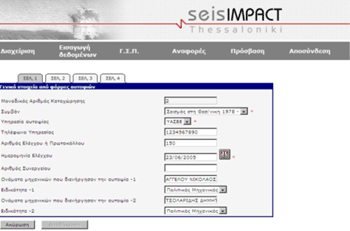
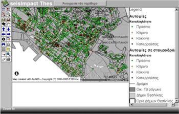
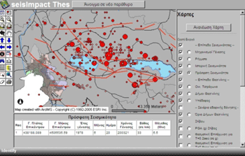
A Web-based entry tool has been developed for the quick and reliable input of data details in the database (fig. 2). In this way, a valid Internet connection and a portable computer are only needed in order to record damage data from anyplace at anytime. The digital map displays city blocks and roads as well as different municipality boundaries including detailed demographic data and vulnerable sites (hospitals, schools etc.). Addresses of buildings whose damage has been stored in the database are linked to their geographical location on the map through an address-matching procedure (fig. 3). Additional layers of information include soil properties, as well as seismological and geotechnical data, such as historical and instrumental seismicity (fig. 4). Fig. 1. Typical SEISIMPACT-THES display on user’s screen (in Greek) Fig. 2. Web-based entry tool of the SEISIMPACT-THES System (in Greek) Fig. 3. Location and post-earthquake building safety classification (Green: Usable – Yellow: Temporarily unusable – Red: Unusable, dangerous) (in Greek) Fig. 4. View of the area of Thessaloniki along with soil-types, recent seismicity and geologic faults (in Greek) |
|||||||||||||||||||||||||||||||||||||||||||||
Pages: 1 2


 (No Ratings Yet)


