Articles in the GNSS Category


Research and development on methods for supporting “safety-of-life” applications with satellite navigation began well before the achievement of Initial Operational Capability (IOC) of the Global Positioning System (GPS) in 1993…

It is generally believed that exploitation of Global Satellite Navigation Satellite System (GNSS) together with advanced mobile communications for signalling and train control will significantly improve safety…

GPS positioning system is designed to determine the position of a point any time and at any place with an accuracy that could reach a few millimeters depending…

In the first semester of 2015, ESSP, the EGNOS service provider, deployed EGNOS System Release (ESR) v2.4.1M. This was a major achievement…

Nowadays, GPS are used in many applications such as GBAS, SBAS, EGNOS and WAAS aircraft landing systems, unmanned road or aerial vehicles, wireline…

The signaling system plays one of the most important roles in railway applications. In fact this segment is not only responsible for providing safety…

In August of 1990, I was a U.S. Coast Guard Chief Petty Officer at the newly established Coast Guard Group Honolulu operations center. I managed day to day operations…

The vulnerability of GNSS to radio frequency interference and spoofing becomes more and more of concern for navigation applications which require a high level of accuracy and reliability…
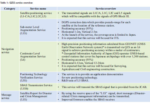
On November 18, 2015, the Quasi-Zenith Satellite System Service Co., Ltd. (QSS) conducted an experiment in Kyoto, Japan using a quasi-zenith satellite system…

When you think about it, GNSS is miraculous. Actually, like most magic, it is best for most people not to think too much about it. They just accept that today’s cars know…


 (5.00 out of 5)