


This report presents ten case studies on LRS ASD approaches – 6 where PPP has been fully adopted; two outright rejections (one of which also considered full privatization); and two which have adopted alternative approaches…

The Northern Territory (NT) has been able to introduce innovative digital survey and cadastral management for Land Administration….

Within the “Tarquinia Project” and the “Centro di Ricerca Coordinato”, involving different groups of the Università degli Studi di Milano (Archaeology, Computer Science and Communication, Geoarchaeology, Palaeoanthropology)…
Volume XV, Issue 11, November 2019
Zip
Recent activity of international standardization for high-accuracy GNSS correction service
Rui Hirokawa
Remote Sensing for air pollution control
A K Jain
Global experiences with public private partnerships for land registry services: A critical review
Keith Clifford Bell
My Coordinates
EDITORIAL
His Coordinates
Peter Teunissen
Conference
Intergeo
Mark your calendar
November 2019 to October 2020
News
INDUSTRY| GNSS| GIS | UAV| IMAGING | LBS
Advertisers …
November 2019
International Navigation Conference 2019
18 – 21 November Edinburgh, Scotland
https://rin.org.uk/events
GEOTEC HANOI 2019
November 28-29, 2019 Hanoi, Vietnam.
https://geotechn.vn
December 2020
Amsterdam Drone Week
4-6 December 2019
www.amsterdamdroneweek.com
International Committee on Global Navigation Satellite Systems (ICG)
8 – 13 December Bengaluru, India
www.icg14.org
International Workshop on ‘Capacity building and Education Outreach in Advanced Geospatial Technologies and Land Management’
10 – 11 December, 2019 Dhulikhel, Nepal
www.lmtc.gov.np/workshop
39th INCA International …
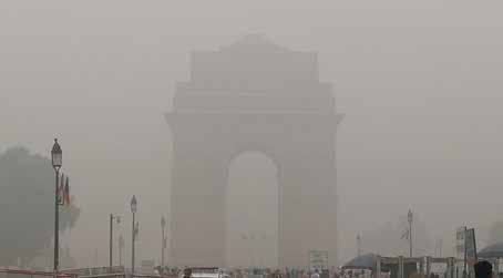
Gasp Chamber
With air quality at dangerous level
This time around air pollution in Delhi
Led to health emergency.
Several desperate measures were taken,
Banned on construction activities,
Plying of vehicles with odd-even numbers on odd and even dates
Schools closed for few days,
Alas! not with desired results.
The Supreme Court of India fumes,
Governments scramble for actions, politicians blame each other,
And the saga …

Professor Peter Teunissen
shares his views on a wide range of subjects related to GNSS
Professor Peter Teunissen has recently received Johannes Kepler Award from ION for his influential and groundbreaking contributions to the algorithmic foundations of satellite navigation and sustained dedication to the global education of next generation of navigation engineers (https://www.ion.org/ awards/2019- Kepler.cfm ). He …
Underground infrastructure mapping solution for collector for ArcGIS by Eos
Eos Positioning Systems, Inc., the leading manufacturer of high-accuracy Arrow GNSS receivers — has released its highly anticipated underground utility asset-mapping solution: Eos Locate for Collector for ArcGIS. It combines three core technologies: Eos Arrow GNSS receivers, Esri Collector, and the Vivax- Metrotech vLoc Series …
New aircraft to carry full range of UAV scanners by LiDARUSA
LiDARUSA a global leader in the design and integration of economical LiDAR sensors announced a partnership with Innoflight Technology, a manufacturer specializing in UAV systems for surveying, mapping, and inspection. As a result of the partnership, LiDARUSA is offering the Galaxy 950 platform to …


 (5.00 out of 5)