The ION releases the GNSS Software Defined Radio (SDR) metadata standard
The Institute of Navigation’s (ION) GNSS Software Defined Radio Metadata Standard document has been published and is available at sdr.ion.org.
The Global Navigation Satellite Systems Software Defined Radio Sample Data Metadata Standard is the product of a three year long effort of the ION …

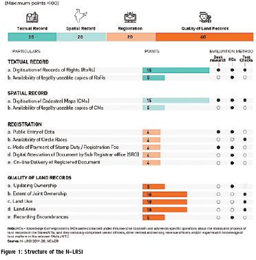
NCAER releases India’s first Land Records and Services Index
National Council of Applied Economic Research (NCAER), released its new Land Records and Services Index (N-LRSI 2020), on Thursday, 27th February, 2020.
The N-LRSI assesses the extent of digitisation of land records and the quality of these land records in the States and Union Territories of India. Madhya …

Volume XVI, Issue 2, February 2020
Zip
Geographic coverage expands as imaging technology matures
Alexander Wiechert
Emerging PNT and GNSS Technology Trends: Creating Resilient, Wireless Connected Systems
John Fischer
Challenges for 3D mapping
Graham hunter
Application of GIS and remote sensing in urban planning
Mohd. Monis Khan
Identifying GNSS market in Indonesia before and the future
Heri Andreas and Sandy Noveriansyah
Spatial Analytics and Deep Learning in …

Novel Scare
COVID-19 has spread
All across the globe, almost.
With over 4000 death counts
And over 1,27,000 infected,
Countries struggle to contain it.
The World Health Organization declares it a pandemic.
This is unprecedented.
Along with the health crisis, the world economy is in a quandary.
A time for self-isolation, if needed
But to collaborate and support each other, surely.
A global crisis looms large.
Humankind …
March 2020
Geo Week
March 23-25, Washington, DC
www.geoweek.com, www.lidarmap.org
HxGN LIVE India
24-25 March 2020 Delhi, India
https://hxgnliveindia.com
April 2020
United Nations/Mongolia Workshop
on the Applications of GNSS
13 – 17 April
Ulaanbaatar, Mongolia
www.www.unoosa.org
SpaceTimeAI 2020
20 – 22 April London, UK
www.ucl.ac.uk/civil-environmentalgeomatic-engineering/
May 2020
China Satellite Navigation Conference
May 2020
Chengdu, China
www.beidou.org
XPONENTIAL 2020
4 – 7 May
Boston, USA
www.xponential.org
GISTAM 2020
7-9 May Prague, Czech Republic
www.gistam.org
FIG Working Week 2020
10 -14 May Amsterdam, the Netherlands
www.fig.net
European Navigation …
Vexcel Imaging to acquire Image Resources from Verisk
Vexcel Imaging, a leader in aerial imagery data, large-format aerial cameras, and photogrammetry software, signed a definitive agreement on 21st Jan 2020, to acquire the imagery sourcing group from Verisk’s Geomni business. The acquisition will combine Geomni’s imagery surveying and content-related teams and assets into Vexcel. Verisk, …


 (5.00 out of 5)